Tyrone
Location, Access, Description
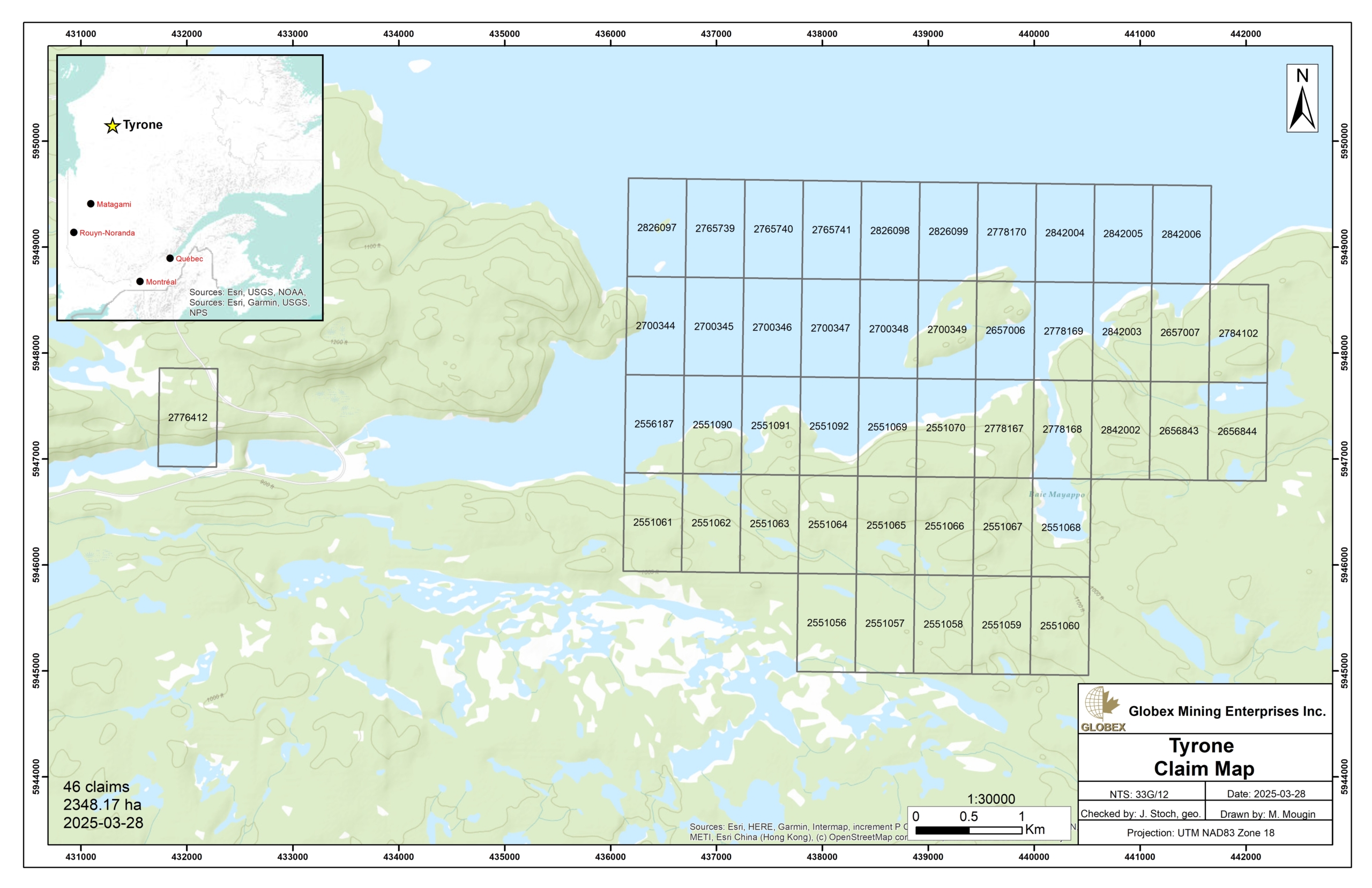
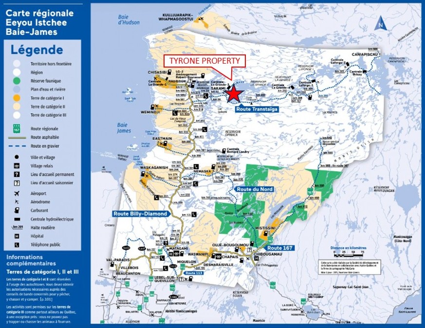
The Tyrone property consists of 46 claims covering an area of 2,348.17 Ha in Eeyou-Istchee James Bay Territory, approximately 450 km NNE of Matagami (Qc) and 105 km east of Radisson (Qc). The claims are wholly owned by Globex Mining Enterprises Inc. and are located on Category III lands where exploration is allowed under conditions due to the fact that the Cree Nation has hunting, fishing and trapping rights. The claims are not subject to any third-party agreements or royalties.
The property is accessible via the road linking Matagami to the LG-3 hydroelectric power station and the village of Sakami. From the Trans-Taïga road linking the villages of Radisson and Caniapiscau, an access road to the LG-3 complex ends 2.5 kilometers west of the property. The property is also accessible by boat from dike TA-26, about 5 km west of the LG-3 reservoir.
Workers involved in the project can stay and eat at the LG-3 Hydro Quebec facilities in Sakami (Qc), about 6 km west of the property. Helicopter can be parked at LG-3 airport (YAD) about 18 km SW of the property.
Geology and Mineralization
Regional Settings
The property is located in the oriental section of the Superior Province of the Canadian Shield, in the La Grande Subprovince, bounded to the north by the gneisses and plutonic intrusions of the Minto Subprovince and to the south by the metasediments and plutonic intrusions of the Opinaca Subprovince. The Minto is intrusive in the La Grande sequences (RG 2001-13). In the property area, the Minto Subprovince is composed of quartz-monzodiorite of both Radisson Pluto and Salleneuve Suite (RG 2011-05), while the Opinaca is represented by metamorphosed wackes, mudrocks and paragneisses of the Laguiche Complex (RG 2000-10).
The La Grande Subprovince represents a volcanic-plutonic complex comprising Archean tonalitic basement (3.36 to 2.79 Ga), and the volcano-sedimentary bands of the La Grande River and the Lower Eastmain River (RG 2001-13 ; MB 97-30 ; MB 96-04 ; MM 94-01). These bands are characterized by the presence of ancient volcanic rocks (2,880 to 2,820 Ma) and younger volcano-sedimentary sequences (2,732 Ma). They are intruded by synvolcanic, syntectonic and late-tectonic intrusions of felsic to ultramafic composition.
According to Hocq (MM 94-01), the boundary between the Opinaca and La Grande generally corresponds to regional shear zones injected by tonalitic and granodioritic intrusions. This boundary is also characterized by an abrupt change in the metamorphic grade from middle amphibolite in the La Grande to upper amphibolite or granulite in the Opinaca.
The structural style of the region is complex. It results from the superposition of ancient ductile deformation affecting the gneisses prior to the emplacement of the volcano-sedimentary sequence, polyphase tectonics comprising kilometres of faults and folds affecting the volcano-sedimentary sequence, and a phase of folding into domes and basins (RG 2001-13).
Three (3) generations of proterozoic diabase swarms aged 2.07 to 2.5 Ga intruded the Archean rocks of the area. Mistassini dykes are NNW-oriented, Senneterre dykes are NNE-oriented and Lac Esprit dykes are N- to NE-oriented (RG 2001-13).
Eade (1966) defined the Sakami Formation to refer to several isolated patches of sedimentary rocks lying unconformably on Archean rocks in the Superior Province. These flaps are generally associated with half-grabens and grabens bordered by brittle faults (GM37017). The sedimentary rocks of the Sakami Formation form subhorizontal benches (dipping E, SE or SSE from ~15 to 40°) resting in erosional unconformity or fault contact on Archean rocks of the La Grande Subprovince and southern Minto Subprovince (RG 184; DPV 730; RG 99-06; RG 2001-13; RG 2000-10; RG 2002-11; RG 2011-01; RG 2015-02). Proterozoic-age faults that bound the sedimentary basins of the Sakami Formation continue within Archean units (RG 2011-01). Based on cross-referencing with Neoarchean (Mistassini Dyke Swarm) and Paleoproterozoic (Senneterre Dykes, Lac Esprit Dykes) diabase dykes, Goutier et al. (RG 2001-13) estimated an age between 2,510 Ma and 2,216 Ma. Goutier et al. (RG 2000-10) calculated a maximum thickness of 1,500 m for this unit.
Property Geology
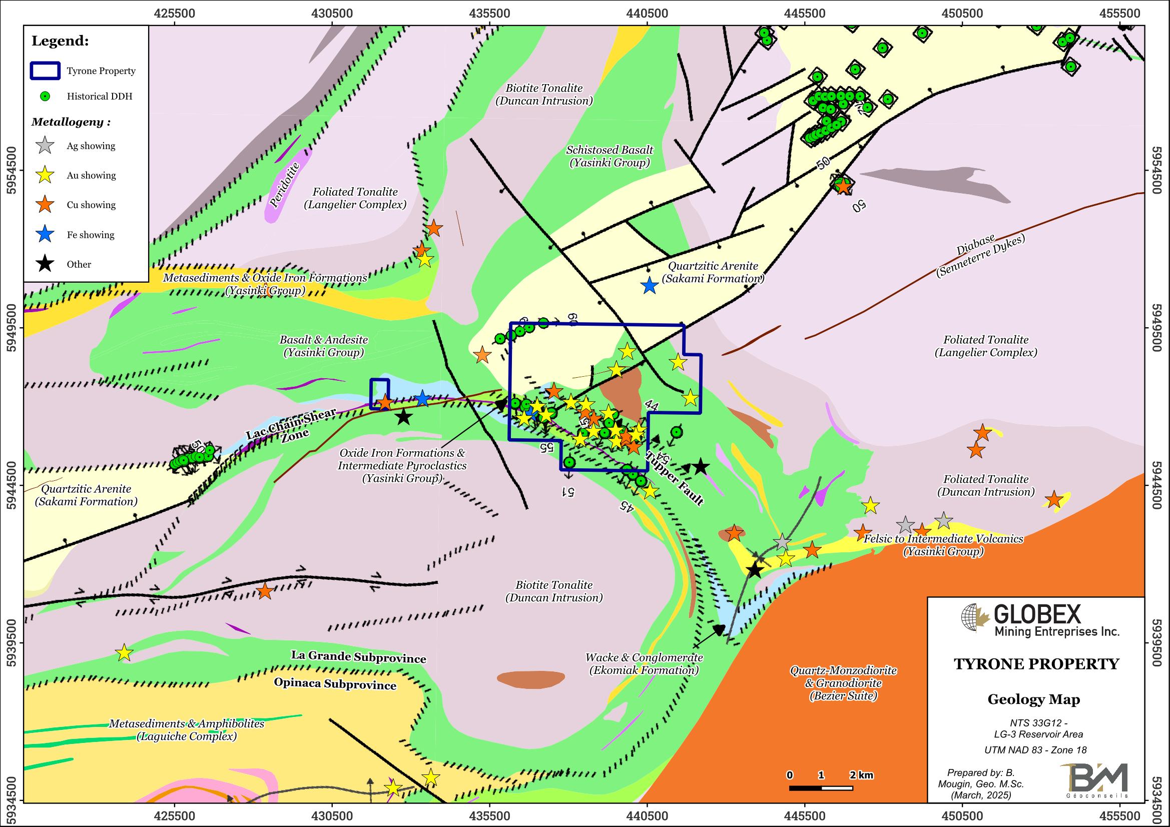
The Tyrone property lies in the central part of the Yasinski Group volcanic-sedimentary belt of the La Grande Subprovince. This sequence is dominated by mafic metavolcanics with few detrital metasediments and lenticular iron formations. These metavolcanics are essentially composed of massive, pillowed andesitic-basaltic flows of tholeiitic affinity, generally chloritized and amphibolitized. Some oxide iron formations and intermediate pyroclastic flows are locally observed in concordance within the mafic volcanics. Several gabbroic sills and porphyritic diorite dykes have been injected into this volcanic pile.
In the north part of the property, the Sakami Formation lies in a NE-oriented sedimentary basin bordered with normal faults. On the Tyrone property, rocks of the Sakami Formation are composed of quartzitic arenite with local presence of coarse to conglomeratic white sandstone (RG 2000-10; GM37017).
Lenses of sediments of the Ekomiak Formation are also mapped within volcanics of the Yasinki in the property area. The Ekomiak consists of clastic rocks (wacke and conglomerates) associated with fluvial or alluvial environment (BG 2019-05).
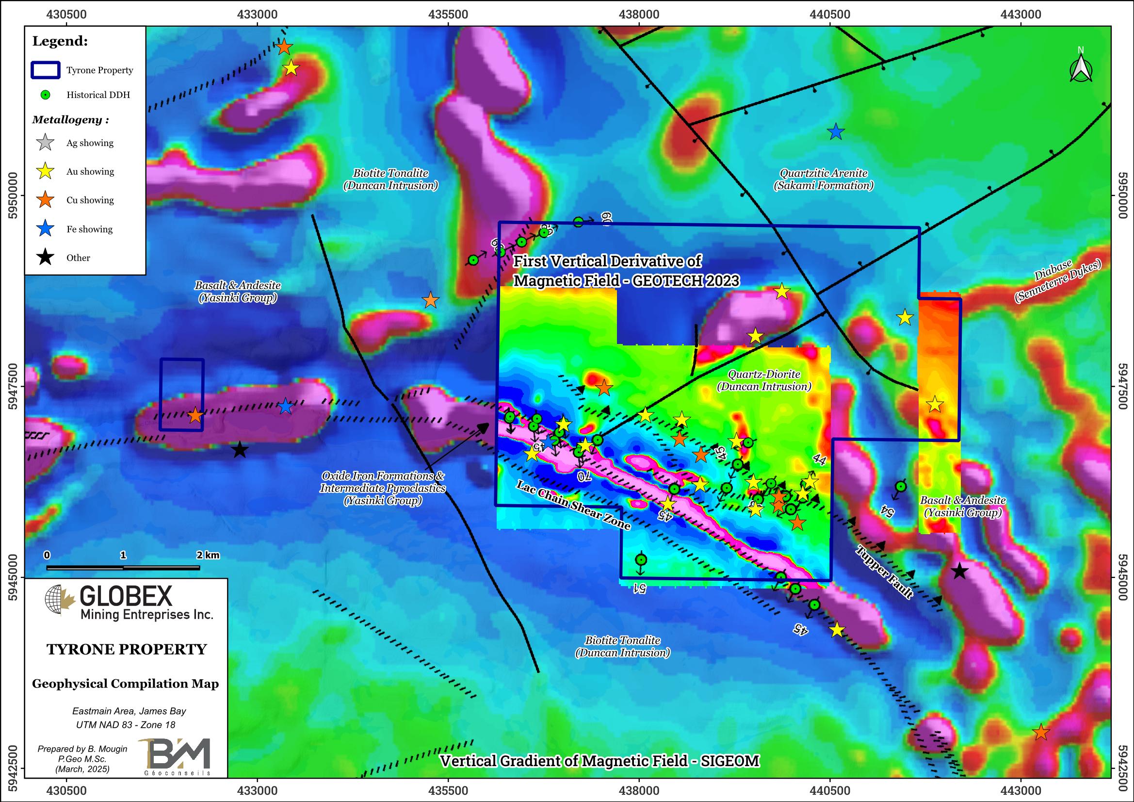
This volcano-sedimentary band has undergone an arcuate inflection against a large tonalitic pluton (Duncan Intrusion). This inflection is accommodated by NW-SE-trending shears, parallel to the contact of the pluton with the volcano-sedimentary band, the main ones being the Chain Lake shear to the south and the Tupper fault to the north (GM72274). The latter has been described as a southwest-verging reverse fault, and several showings on the property appear to align with it.
The Duncan intrusion is mapped both SW and NE of the Tyrone property and essentially consists in massive to foliated biotite ± hornblende tonalite which is distinguished from the tonalites of the Langelier Complex by a more homogeneous petrographic structure and less deformation (RG 98-09). The Langelier Complex represents the oldest rocks in the La Grande Subprovince. In the area of the property, the Langelier Complex is represented by foliated tonalite and granodiorite with local gneissic textures.
The main structure described on the property is the ESE-trending Chain Lake syncline, which dips to the south and plunges to the NW (GM55561).
Metamorphism in rocks of the Tyrone property is at the greenschists to lower amphibolitic grade so that volcanic textures are locally well-preserved (RG 2001-13).
Regional Metallogeny
Up to nine (9) types of mineralization are recognized in the region (RG 2001-13): 1) Algoma-type iron formation volcanogenic mineralization ; 2) Cu-Ag ± Au mineralization in tuffs or wackes and their metamorphosed equivalents their metamorphosed equivalents ; 3) stratabound gold mineralization associated with iron formations ; 4) Cu-Ag ± Au vein mineralization ; 5) gold mineralization associated with deformation zones ; 6) magmatic Cr mineralization ; 7) vein-type uranium mineralization (Proterozoic) and 8) polymetallic mineralization (Proterozoic).
Property Mineralization
The property is recognized by the presence of several gold and base metal showings, some of which are associated with mafic metavolcanites and others with oxide iron formations. These gold mineralizations can be grouped into 3 different types:
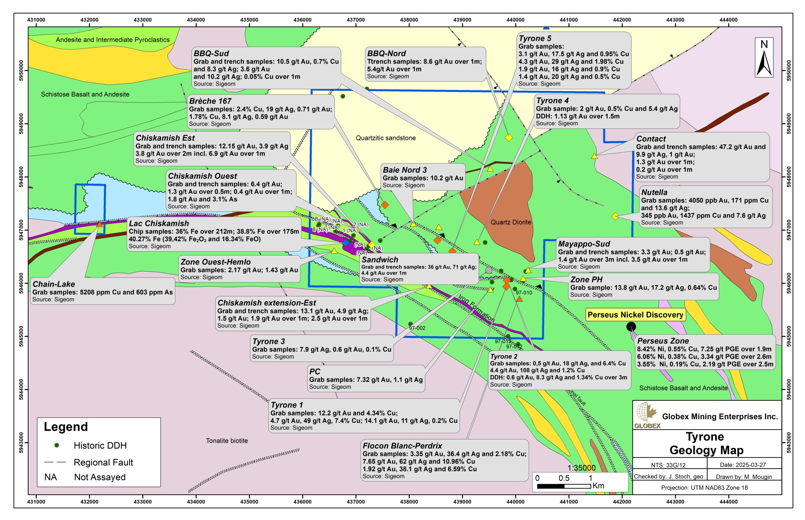
- Volcanogenic sulfides with pyrite and chalcopyrite inter-pillows and/or disseminated in altered metavolcanites such as the Baie, Baie Nord 2, PH and the six Tyrone showings 1 to 6. To date, this type of mineralization has not yielded economic gold values.
- Lode-type mineralization with quartz-tourmaline veins associated with pyrite-chalcopyrite-hematite sulfides returned good gold values in grab samples from schistose mafic metavolcanics. This includes the Baie Nord showing (8 g/t Au, 28.9 g/t Ag, 0.1% Cu), Baie Nord 3 (10.2 g/t Au, 0.9 g/t Ag, 0.3% Cu), PH (13.8 g/t Au) and Tyrone 1 showings (14.0 g/t Au, 4.7 g/t Au; 12.2 g/t Au, 4.3% Cu), Tyrone 2 (4.4 g/t Au, 107 g/t Ag, 1.2% Cu), Tyrone 3 (0.6 g/t Au, 7.9 g/t Ag, 0.1% Cu), Tyrone 4 (2,0 g/t Au, 5.4 g/t Ag, 0.5% Cu), Tyrone 5 (4.3 g/t Au, 29 g/t Ag, 1.98% Cu) and Tyrone 6 (20.6 g/t Au, 89.5 g/t Ag and 11.6% Cu; 21.0 g/t Au). The six (6) Tyrone showings #1 to #6 and the PH showing show two styles of mineralization, syngenetic volcanogenic and epigenetic veinlet.
- Lode-type with gold mineralization both in magnetic sulphide bands (1-3% pyrite and 1-2% arsenopyrite) and at the edges of stratiform quartz veins in sheared and/or folded oxide iron formations in contact with schistose basalts. There appears to be a positive correlation between high arsenopyrite grades and the gold values returned on grab samples. This mineralization style is observed on the Chiskabish West (4 g/t Au) and East (12.0 g/t Au; 6.2 g/t Au 4.0 g/t Au and 6.9 g/t Au / 1.5 m) showings.
History
The following section is essentially taken from Amrhar (2020 – GM72274).
The area has been mapped several times by MERN geologists. Eade (1966) first mapped the La Grande volcanosedimentary band for the Federal Government. Then, Sharma (RG 184), Ciesielski (1984), Chartrand and Gauthier (PRO-95-06), Gauthier (MB 96-04) and Goutier et al. (RG 2001-13) each added their own point of view.
Exploration work by private mining companies started in 1959 with Tyrone Mines Ltd. which undertook aerial reconnaissance work, geological mapping, sampling, trenching and diamond drilling (GM10510). Both Tyrone #1 and Tyrone #2 were discovered at that time. In 1960 Tyrone Mines carried-out aerial magnetic and electromagnetic surveying followed by detailed prospection around the anomalies.
In 1964, Dodge Phelps implanted ten (10) DDH totaling 4,806 ft (1,465 m) in the Chiskamish Lake area, in the SW part of the property in order to estimate the iron potential of a 200 metres wide oxidized iron formation (GM15511). These holes do not appear to have been assayed for gold, and drill logs numbered 64-01 to 64-08b show no assay results.
The Société de Développement de la Baie-James (SDBJ) carried-out numerous geochemical surveying in the area of the property during the 1970s (GM34044, GM34085, GM50002), as well as aerial prospection by photo-interpretation (GM34114), geophysical surveys (GM34107, GM34129, GM50021) and DDH (GM34143).
In 1986, Eldor Resources Ltd. resampled the Tyrone #1, #2 and #3 showings. 26 grab samples were assayed for both gold and copper content. Copper grades were similar to those reported by Tyrone Mines Ltd. (up to 2% Cu), but gold grades did not exceed 1.03 g/t Au (GM47237).
In 1993-1994, Hemlo Gold Mines prospected the LG-2 and LG-3 areas and completed a magnetic and EM-VLF survey (GM52590). Trenching and channel-sampling were carried out in the Chiskamish Lake area (GM53741). Best assays included 1.9 g/t Au over 0.50 m (#3 trench) and 1.1 g/t Au over 2.10 m (#1 trench).
In 1996-1997, Virginia-Barrick and Sirios Resources Inc. conducted an airborne magnetic and electromagnetic survey over the LG-3 property area. Sirios Resources Inc. completed a 1:5,000 mapping and ground geophysical survey (GM55560). Geological sampling and mapping carried out during the summer of 1996 on the LG-3 property (GM55563) revealed numerous mineralization zones associated with different geological environments. The geophysical anomalies and mineralized showings previously identified were tested in 1997 by sixteen (16) drill holes totalling 2,358 m in the area of Tyrone #1 to #4 showings (GM55561). Assays up to 1.34% Cu, 8.3 g/t Ag and 0.6 g/t Au over 3 m were obtained on DDH 97-07, and 1.92 g/t Au over 1.5 m on DDH 97-16. The eastern and southeastern extensions of the Tyrone #1 showing show several significant induced polarization conductors. Sirios Resources Inc. also completed prospecting at the Beep Mat east of Mayappo Bay (GM 55818), which led to the discovery of the Contact gold showing (47.2 g/t Au and 9.9 g/t Ag).
During the 2000s, Gestion IAMGOLD-Québec Inc. conducted till sampling, ground induced polarization (IP) surveys and diamond drilling in the area of the property (GM63035). Then, in 2007, the company compiled the historical work (GM63036) and proposed a program of eight (8) drill holes, six (6) of which are located on the Tyrone property. These DDH don’t seem to have been drilled yet. In 2009, Eloro Resources Ltd. compiled its Sakami property, including the Tyrone project (GM65786). This work established a positive correlation between lake-bottom sediment geochemical anomalies (GM34039) and the presence of mineralized showings.
In 2014 and 2015, Exploration Osisko Baie James Inc. completed a reconnaissance program on the Sakami property, followed by mapping with sampling and multi-element analyses of the Breccia 167 showing located on the Tyrone property (GM69203). The best channel sampling results were obtained from brecciated magnetite-chalcopyrite-quartz veins hosted in hematite-epidote- and calcite-altered mafic volcanics. The best grades are 2.12% Cu, 0.72 g/t Au and 2.16% Cu, and 0.42 g/t Au. They are interpreted as IOCG-type mineralization worthy of further exploration.
In 2023 Globex Mining Enterprises has commissioned a very high-resolution helicopter-borne magnetic survey on the Tyrone property.
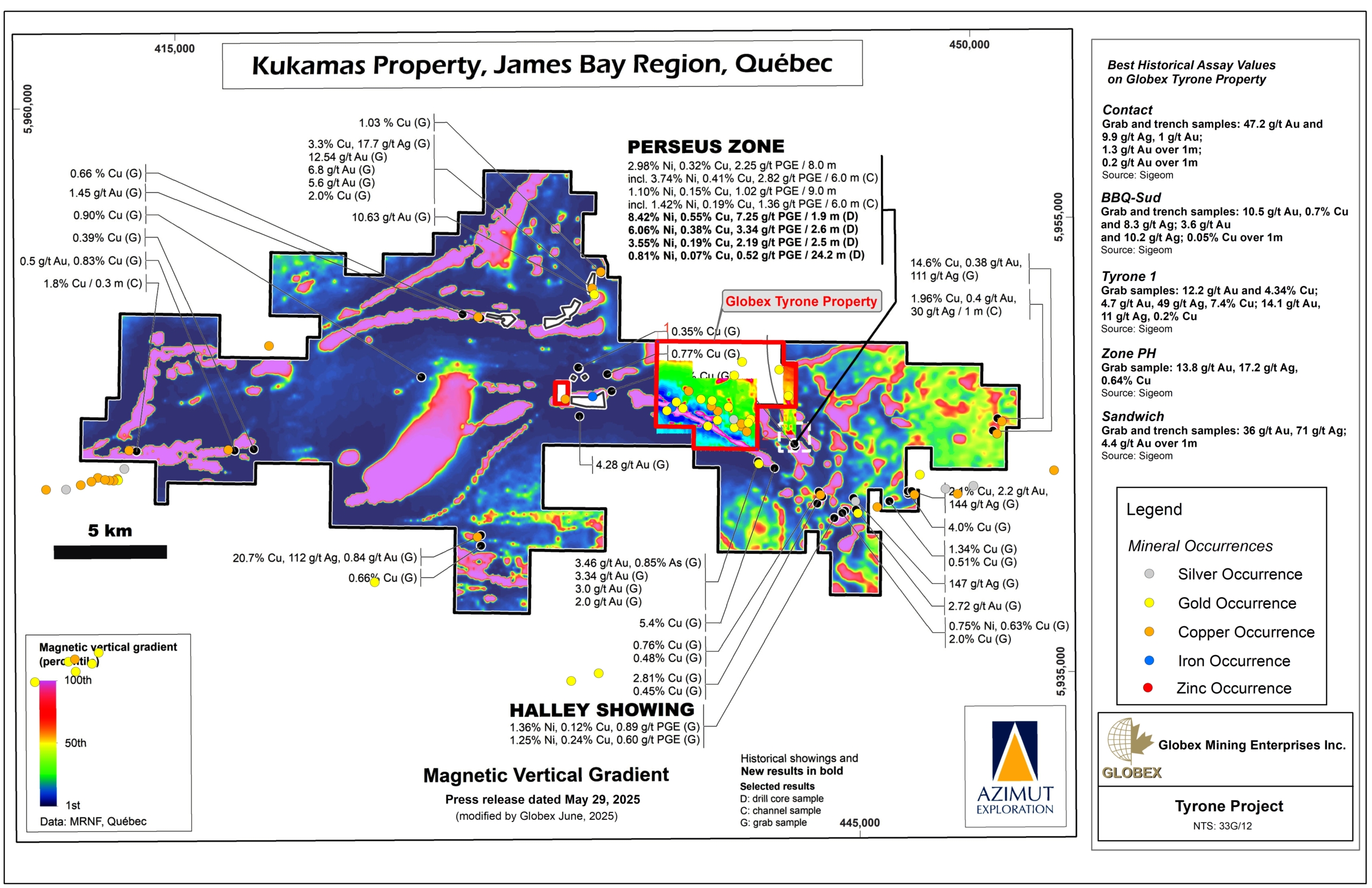
Between 2023 and 2025, Exploration Azimut reported highly anomalous Ni and PGE assays in both grab samples and DDH (PR dated from May 29, 2025) on the Perseus Zone located only 1.6 km southeast of the Tyrone property (see Azimut’s vertical gradient mag map attached below). Grab samples ranging from 3.46% to 19.60% Ni are commonly associated with high palladium grades ranging from 1.16 g/t Pd to 12.15 g/t Pd, and high platinum grades up to 3.65 g/t Pt. Significant grades for the rarest PGEs are associated too, with up to 1.16 g/t Rh, 0.43 g/t Ir, 2.75g/t Ru and 0.45 g/t Os. Gold and tellurium contents are also anomalous, with grades up to 1.13 g/t Au and 32.1 g/t Te respectively. Assays up to 8.42% Ni, 0.55% Cu, 7.25 g/t PGE over 1.9 m (Hole KUK24-002) and 1.64% Ni, 0.11% Cu, 1.12 g/t PGE over 8.5 m (Hole KUK24-001) are reported on Perseus in DDH. Detailed mapping as well as further geophysics and DDH are planned by Azimut in 2025.
Resources and Potential
Numerous occurrences of both precious and base metals are listed in the Tyrone property area. These mineralized zones can be sorted into three (3) different styles : 1) Volcanogenic sulfides with pyrite and chalcopyrite inter-pillows and/or disseminated in altered metavolcanites ; 2) Lode-type mineralization with quartz-tourmaline veins associated with pyrite-chalcopyrite-hematite sulfides and 3) Lode-type with gold mineralization both in magnetic sulphide bands and at the edges of stratiform quartz veins in sheared and/or folded oxide iron formations in contact with schistose basalts.
Significant Au and Cu anomalies have been highlighted in historical work, either in grab sampling, channel-sampling and DDH. Mineralization on the Tyrone property is often associated with ESE-oriented EM and/or IP anomalies, sometimes concordant with magnetic anomalies, which makes it easy to detect in geophysics. Iron (Fe) mineralization is also listed in association with oxide iron formations.
The vertical magnetic gradient map modified from Azimut Press Release dated from May 29, 2025 (see map attached above) clearly highlights the strong association between Ni and PGEs anomalies with strongly magnetic trends in the area of the Perseus Zone. Globex’s 2023 high resolution aeromagnetic survey proves the evident extension of the mineralized and magnetic trends of Perseus on the Tyrone property in a NW-SE orientation.
Further exploration of the Tyrone property is therefore definitely recommended. Future work should include the following recommendations :
- Historical diamond drilling (DDH) compilation in a digital database, and interpretation of cross-sections and long-sections for each area of interest. Ideally, DDH data would be integrated to a 3D block model in order to better visualize both lateral and in-depth extensions ;
- Compilation of all historical geophysical public data from Sigéom in a GIS project ; new ground EM / IP surveys may prove necessary. Due to the mineralization style highlighted in this area, every anomaly associations from different methods (Mag, EM, IP) shall be considered as a priority exploration target ;
- Detailed prospection, geological mapping and sampling of each target generated by this compilation ;
- Mechanical stripping or DDH on the best targets from work mentioned above.

