Kewagama Gold Mine
Location, Access, Description
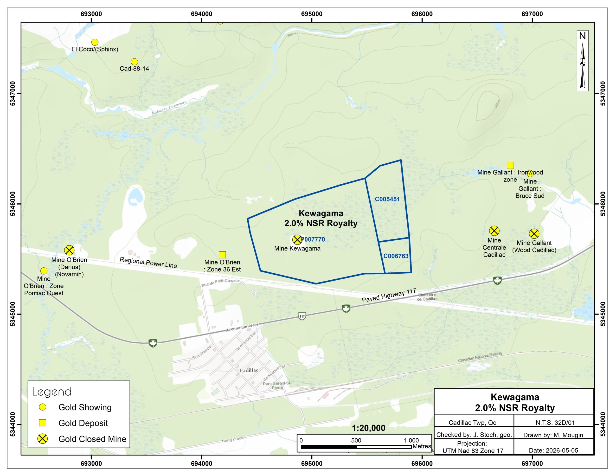
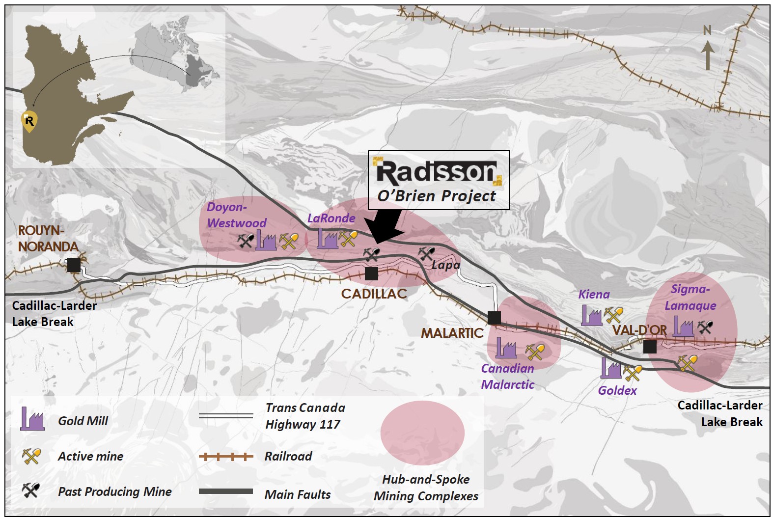
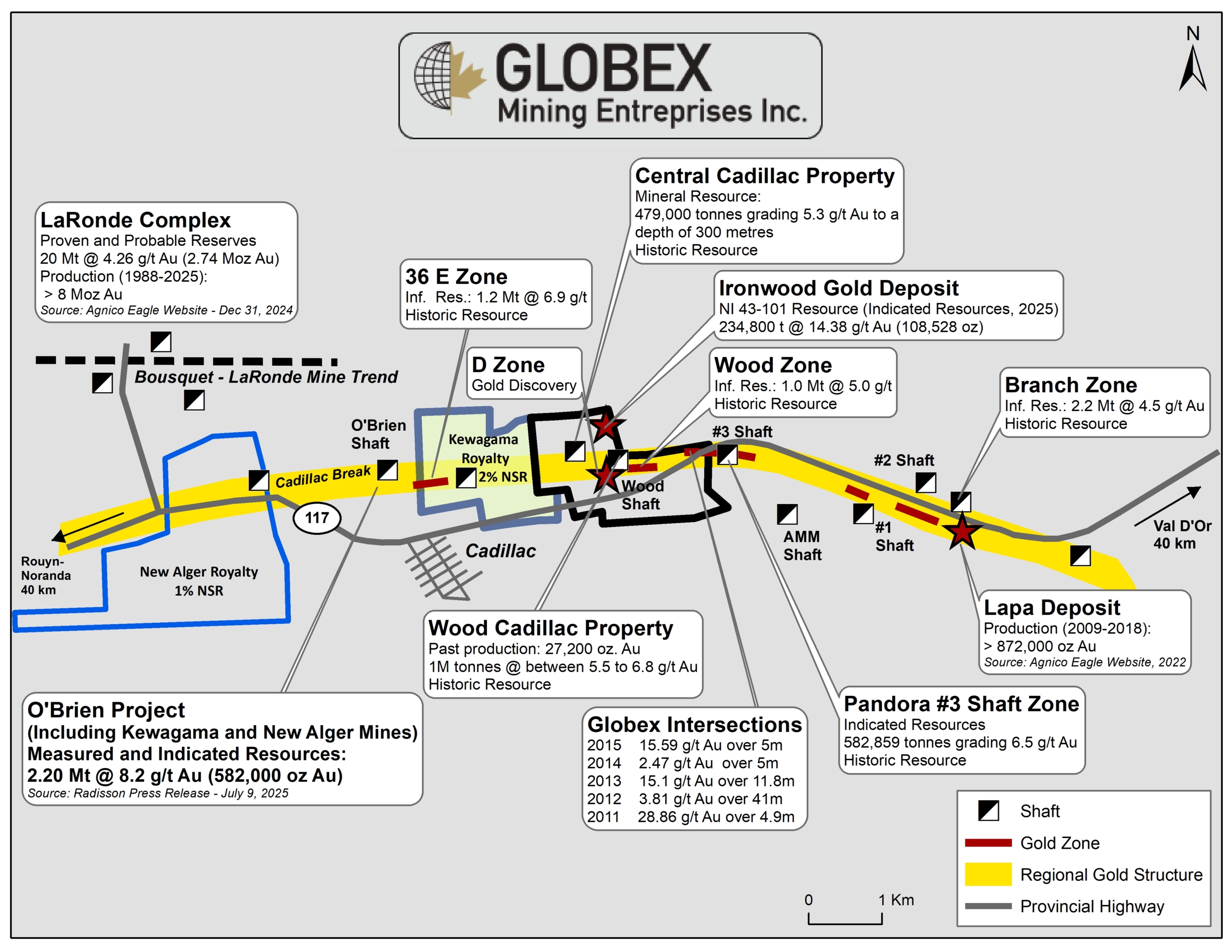
The Kewagama property consists of 6 mining claims covering an area of 221.8 Ha in Cadillac township, MRC of Rouyn-Noranda. The property is located approximately 45 km east of Rouyn-Noranda (Qc) and 45 km northwest of Val-D’Or (Qc). The claims are part of the advanced exploration stage O’Brien Project of Radisson. Globex retains a 2% Net Smelter Royalty (NSR) on three (3) claims of the Kewagama property.
The Kewagama property straddles Trans-Canada Highway 117. The region is associated with several active mines and numerous exploration companies. A full range of infrastructure, service companies, and experienced human resources are available in most nearby communities including Val d’Or, Malartic, and Rouyn-Noranda. Two regional airports, located in the cities of Rouyn-Noranda and Val d’Or, provide regular connection with the main centers of the province (Montreal and Québec City). The Property is also connected to a high voltage power line and is intersected from east to west by the Trans-Canada Railway.
New Mineral Resource Estimate (MRE) of the O’Brien Project in 2026 estimated Indicated Mineral Resources of 3.49 Mt grading 5.59 g/t Au (628,000 oz Au) (Radisson PR dated March 2, 2026). Globex’s NSR covers 20.6% of the total planned gold production of the O’Brien Project (Globex PR dated May 5, 2026).
Geology and Mineralization
The Kewagama property is located on the contact between the Abitibi and Pontiac subprovinces, separated by the Cadillac–Larder-Lake Deformation Zone (CLLDZ). The Abitibi Subprovince is an Archean greenstone belt which hosts some of the richest mineral deposits of the Superior Province whose total endowment, including Production, Reserves and Resources is estimated to be > 9,375 t Au (Dubé and Mercier-Langevin, 2020).
Volcanic and sedimentary rocks of the Cadillac area form a series of east-west-trending steeply dipping monoclonal panels. Sedimentary rocks, mainly wackes, of the Pontiac Group lie south of the CLLFZ. Most of the orebodies in the southern part of the Cadillac mining camp are hosted in rocks of the Piché Group (volcanic rocks interbedded with conglomerates, wackes, graphitic schists and pyritic cherts), which forms a thin band several tens of kilometres long that follows the trace of the CLLFZ (Evans, 2023).
All Archean rocks were deformed and verticalized during the Kenorean Orogeny (2.7 – 2.68 Ga). Regional metamorphism ranges from the greenschist facies to the upper greenschist facies. Non-deformed NE-oriented Proterozoic diabase dykes run throughout the area.
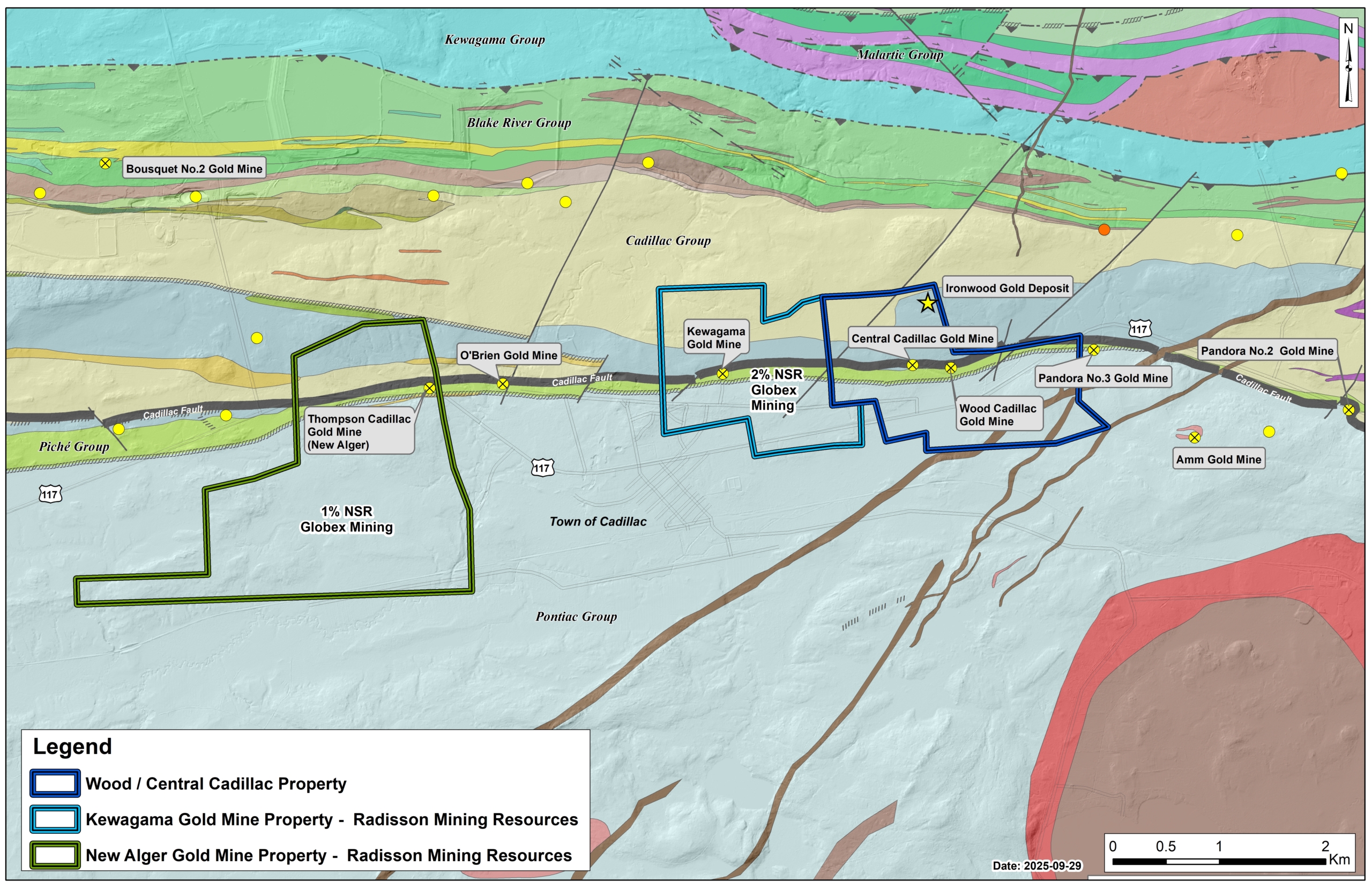
The northern half of the Kewagama property is underlain by steeply south dipping greywackes, mudstones and banded iron formation of the Cadillac Group. The southern portion of the property is underlain by greywackes and lesser mudstones of the Pontiac Group. The sedimentary groups are separated by a narrow but critically important 50-200 m wide band of talc/chlorite schists and mafic volcanic rocks of the Piche Group that strike east-west and dip steeply to the south. The CLLDZ is best developed within the Piche Group mafic and ultramafic volcanic but occasionally widens to encompass parts of the adjacent bounding sedimentary formations.
The Kewagama property is located in the central part of Cadillac Township, in Abitibi, at the heart of one of Canada’s most productive gold mining camps. Most of the gold mineralization in the Cadillac mining Camp is closely associated with the CLLDZ and its subsidiary structures. Approximately 40 gold deposits, which have produced over 60 million ounces of gold since the early 20th century, are associated with this major structure and its subsidiary faults (Evans, 2023 NI 43-101 Technical Report on the O’Brien Project).
The deposits are quartz-lode type, generally consisting of auriferous sulphide-bearing quartz-carbonate shear veins frequently containing free milling gold, disseminated arsenopyrite-pyrite haloes to the veins in shear zones and related structures and to a lesser extent, veins in extensional fractures, structural zones, and breccias. The O’Brien Mine is an inactive underground mine, which experienced intermittent production from 1925 to 1957 and was considered to be the Abitibi Greenstone Belt’s highest grade gold producer during its life, producing 1,197,147 tonnes @ 15.25 g/t Au for 587,121 ounces of gold (Williamson, 2019).
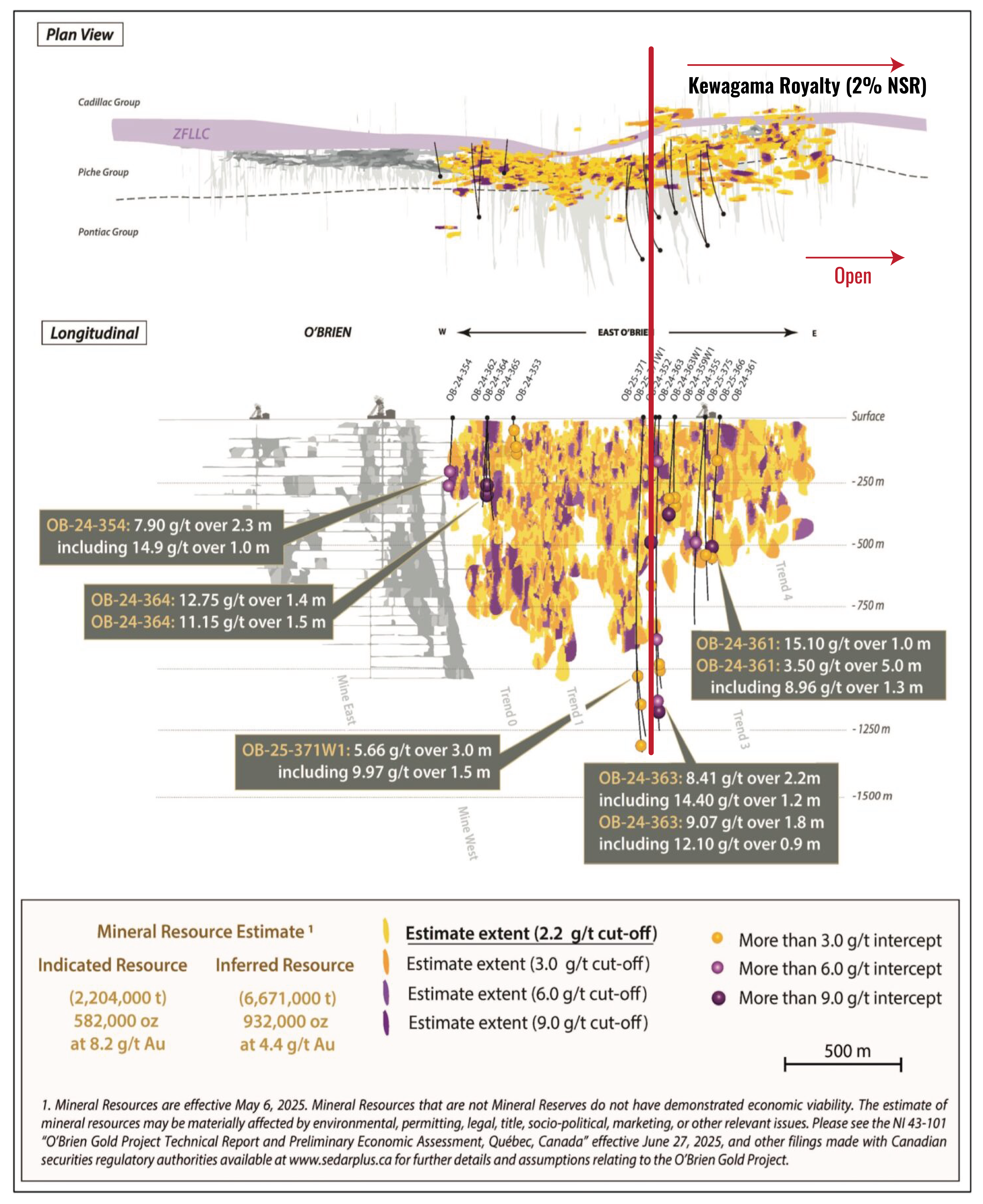
Mineralization is currently defined within two areas of the Project site : O’Brien East, host to both Zone 36 East (east of the historic O’Brien mine) and Kewagama (at-depth extension of the historic Kewagama mine), and O’Brien West, host to New Alger, an at-depth and lateral extension of the historic Thompson-Cadillac mine. In the Kewagama area, the gold mineralization occurs in rocks of the Piché Group, but present as a series of smaller veins instead of bigger single vein as within the O’Brien deposit.
History
The former Thompson-Cadillac Mine (New Alger) entered in production in the 1920s. O’Brien Gold Mines Ltd. began mining the O’Brien deposit in 1925 with the sinking of the first shaft and commencement of underground development. Activity on the Kewagama property commenced in 1928 with trenching and diamond drilling by Cartier Malartic Gold Mines. Continuous exploration indicated that geological and structural conditions of the Kewagama property are essentially similar to those of the adjoining O’Brien property. Exploration revealed the presence of several gold-bearing quartz veins. In 1932-1933, a two-compartment shaft was sank to a depth of 125 ft, deepened several times to a final depth of 700 ft, with three compartments.
All operations at Kewagama were suspended in early 1939 due to the restrictions on gold mining with the outbreak of World War II and never entered in production since. The same year, the Thompson Cadillac Mining Corporation declares bankruptcy; the mine ceases production, with 21,000 oz of gold having been mined (Evans, 2023). Following intermittent activity, the O’Brien mine was shut down permanently in 1981 and allowed to flood in 1985. Total historical production at O’Brien (1926-1957) is estimated to 1.2 Mt @ 15.25 g/t Au, for 587,121 oz Au (Radisson website, September 2025).
In early 1979, and the Kewagama mine was dewatered and secured. Inspection of underground workings took place, followed immediately by sampling and planning (Evans, 2023).
Cadillac Ventures and Renforth Resources established a joint-venture on the New Alger property in 2006 and Renforth acquired full ownership in 2013. In 2020, Renforth completes a Mineral Resource estimate at New Alger then sells the New Alger property to Radisson for CDN$ 4.34M in securities and cash.
Recent work and developments :
After becoming the 100% owner of the Kewagama property in 1999, Radisson compiled existing data and carried out several exploration programs including geophysics and DDH. Between 2015 and 2025, several Mineral Resources Estimate reports were released by Radisson on O’Brien Project. The last in date is a positive Preliminary Economic Assessment (PEA) released in July, 2025, that anticipates underground mining with a life span of 11 years, with 740 k oz Au extracted and 647 k oz Au recovered at an average recovery rate of 87% (see Radisson website for more details).
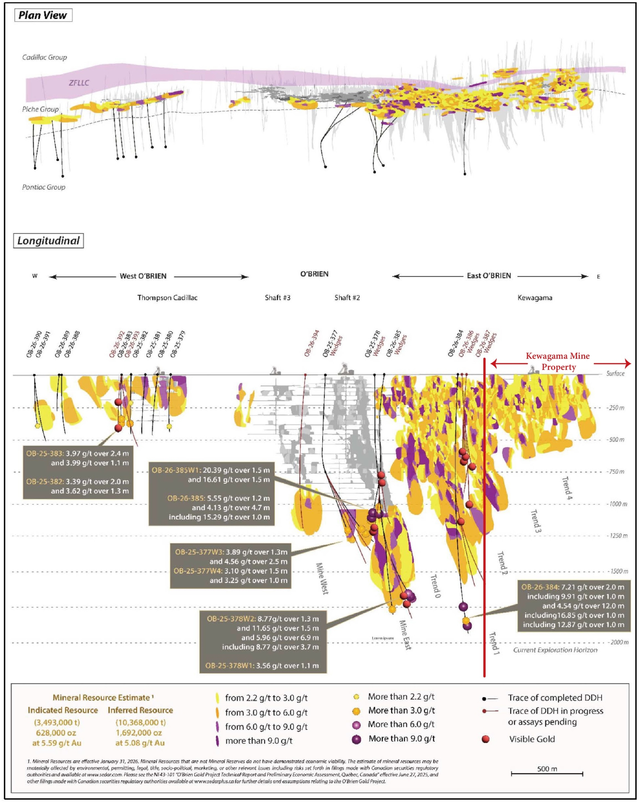
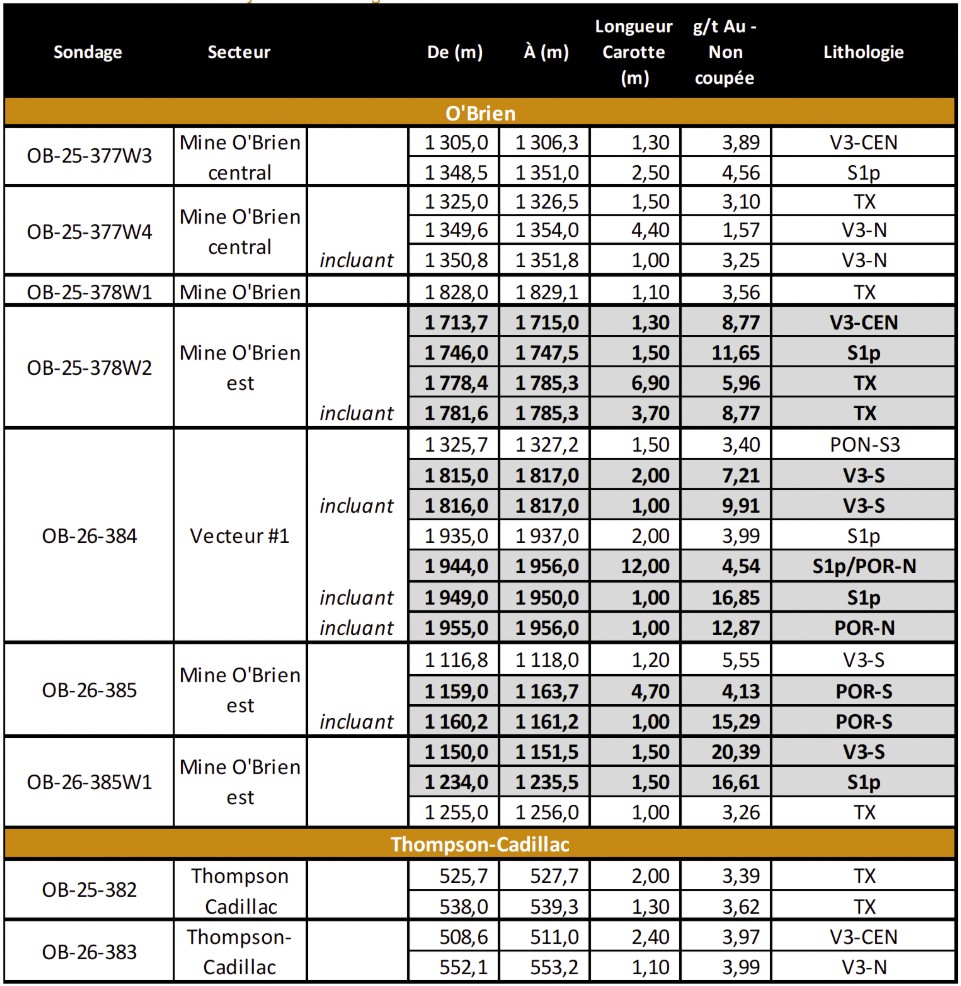
Drilling is still ongoing at O’Brien with a 140,000 meters program planned in 2026 which continues to yield positive results; mineralization grading 4.54 g/t Au over 12.0 m has been intersected at 1.9 km deep (Globex PR dated May 5, 2026). Best recent DDH intersections are presented in the table below :
Resources and Potential
A Preliminary Economic Assessment (NI 43-101 “O’Brien Gold Project Technical Report and PEA, effective date, June 27, 2025) described a low-cost, high-value Project with an 11-year mine life and significant growth potential based on the use of existing regional infrastructure.
A new MRE released in March, 2026 (Radisson Press Release dated March 2, 2026) highlighted Indicated Resource of 3.49 Mt grading 5.59 g/t Au (628,000 oz Au) and Inferred Resource of 10.37 Mt grading 5.08 g/t Au (1.69 Moz Au) which represents a significant increase compared to 2025.
Mineral Resources are essentially located between 0 and -900 m under the Kewagama and O’Brien former mines and all of the mineralized trends dip steeply to the east toward Globex’s Kewagama royalty properties. Recent DDH intersection at 1.9 km deep proved that the property’s potential is fully open at depth toward Globex royalty claims.