
Salt Spring
Location, Access, Description
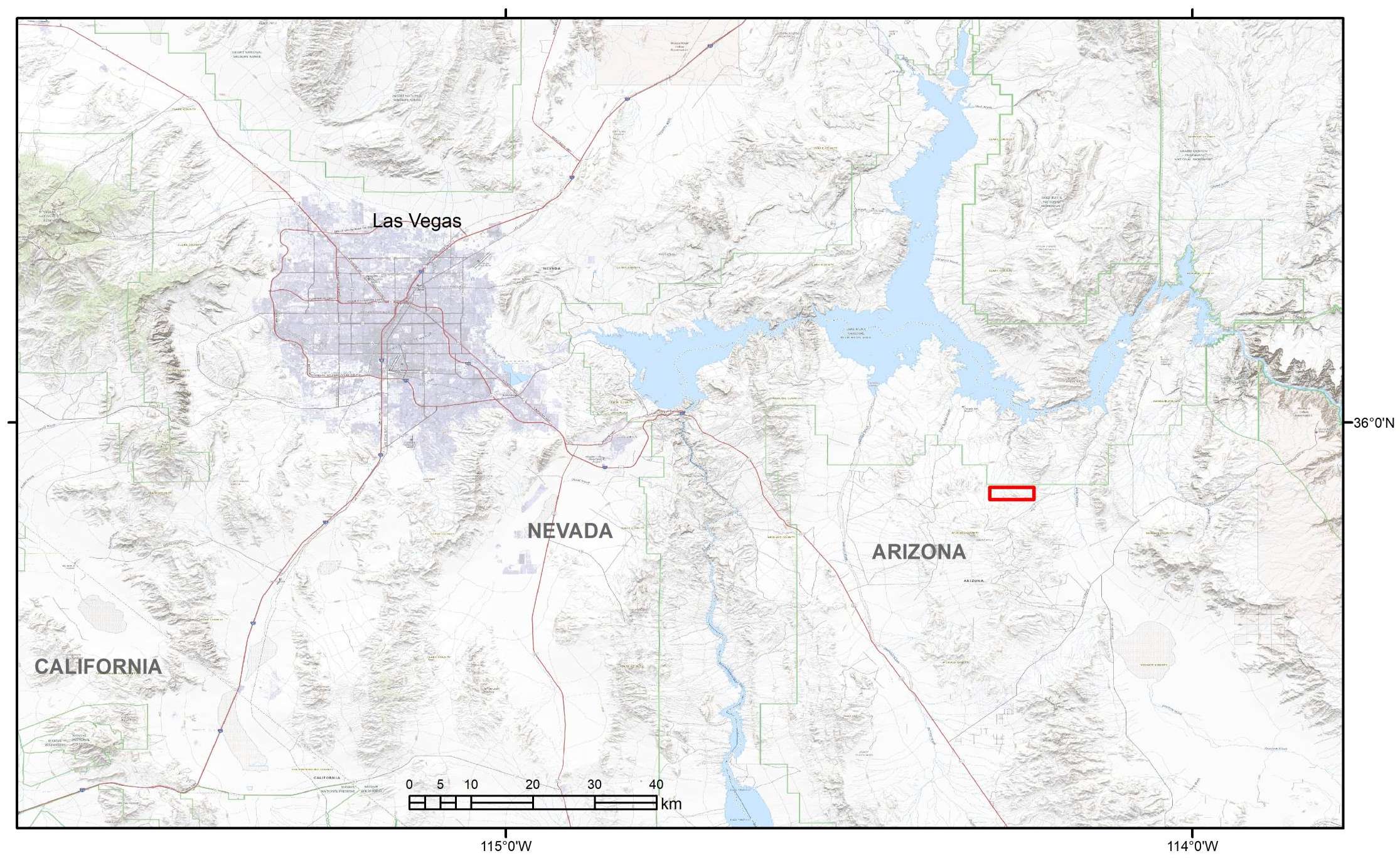
The property was initially staked in September 2023 and its size was expanded by additional staking in March 2025 and March 2026. It is in northwestern Arizona, Mohave County, 85 km southeast of the city of Las Vegas, Nevada and about 15 km south of Lake Mead. The Salt Spring property consists now of 57 unpatented lode claims. The property has a total surface area of 471.77 ha. The entire Globex property lies on public land outside of any conservation area (e.g. areas of critical environmental concern or Wilderness areas). Just north of the Globex claim block is situated the Lake Mead National Recreation Area managed by the National Park Service.
Globex’s Salt Spring project is situated north and northeast of the Golden Rule Peak, having an altitude of 1177 m. Elevations in the project area vary between 800-900 m in the rather flat slightly undulating terrain in its northern and northeastern part and up to 1110 m in the hilly to slightly mountainous region further south. Vegetation with bushes and cactus is typical of the eastern Mojave Desert. Climate is dry with a small average amount of rainfall during the year (mostly rain, but rarely snowfall, during the winter time). Temperatures range from hot during the summer to short freezing periods in winter time.
Access to the western claim block from Las Vegas is driving 82 km on motorway I-11S and US-93S heading southeast (toward Kingman, Arizona), then turning left, using well maintained gravel roads of the White Hills Wind Farm and then gravel and dirt roads until reaching the western claim block. Total driving distance from Las Vegas varies between 125 and 140 km; driving time with four-wheel vehicle is about 2.5 hours.
Access to the eastern claim block from Las Vegas is driving 114 km on motorway I-11S and US-93S heading southeast (toward Kingman, Arizona), then turning left on paved Pierce Ferry Road driving 36 km in northeasterly direction until the junction with Anteras Point Road (after the Chevron gas station). From here a well maintained gravel road is taken in northerly direction for 13 km, then turning west and north reaching after 4 km on good gravel roads a helicopter refueling station. From here the project area is located to the northwest and can be reached via 4×4 dirt roads, distances vary between 2.5 and about 5 km. Also the patio of the historic Gold Hill mine can be accesses by four-wheel vehicle. Total driving distance from Las Vegas varies between 170 and 175 km; driving time with four-wheel vehicle is about 2.5 to 3 hours.
Geology and Mineralization
Regional Settings
The project area is situated at the northernmost margin of the historic Gold Basin mining district. This district is rather large, about 18 km long (N-S) and 7 to 11 km wide. To the east is attached the smaller Lost Basin gold district. The district is dominated by steeply folded high-grade metamorphic rocks of Proterozoic age intruded by numerous granitoid bodies ranging in age from Proteroizoic to Mesozoic. A number of conspicuous major faults and lineaments crosscut the Gold Basin – Lost Basin Mining District. Some might be directly related to gold mineralization, others represent post-mineral faults of Tertiary age. Gold mineralization in the district is not evenly distributed but rather restricted to several distinct gold-corridors.
Regional Geologic Map of the Gold Basin-Lost Basin Mining District, Arizona
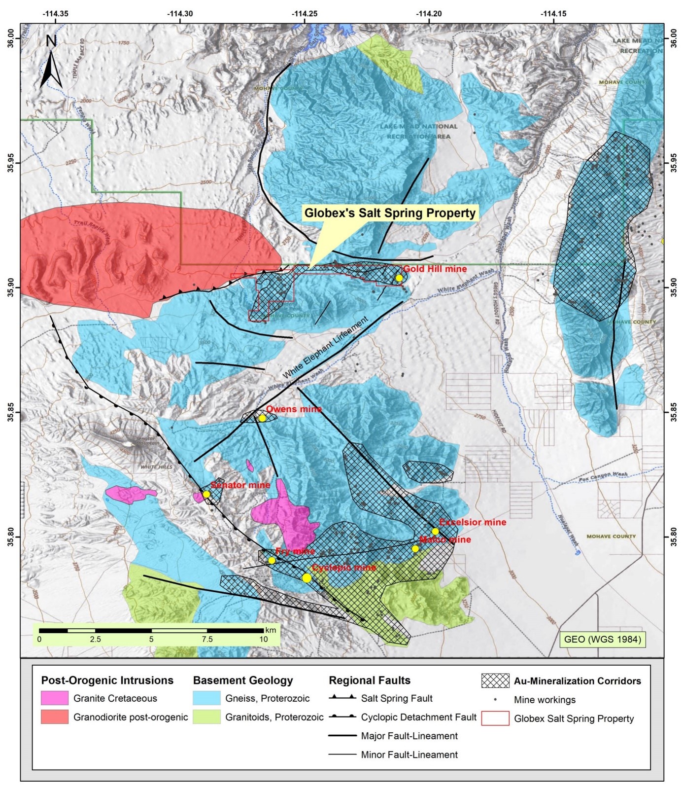 Larger historic Au mines marked as yellow dots. Globex’s Salt Spring Property covers the northern-most about E-W trending gold corridor.
Property Geology
Gold mineralization in the northern Gold Basin district is confined to a roughly east-west orientated 7 km long corridor, ranging in width between 0.4 km and up to 1 km. Globex’s Salt Spring property covers entirely this northern gold corridor. Within this corridor are located a great number of historic exploration pits, cuts and small or medium sized historic mine workings. Within Globex’s Salt Spring property have been identified 22 small mines and at least 70 prospects and cuts.
Gold in the district occurs in narrow, partly high-grade mesothermal quartz-carbonate veins, but the bulk is of low-grade hosted in stockwork- and disseminated zones. It is believed that gold deposition occurred in a mesothermal intrusion-related environment, linked to Cretaceous granitoids, although Miocene hydrothermal (epithermal or brines) overprint is indicated as well.
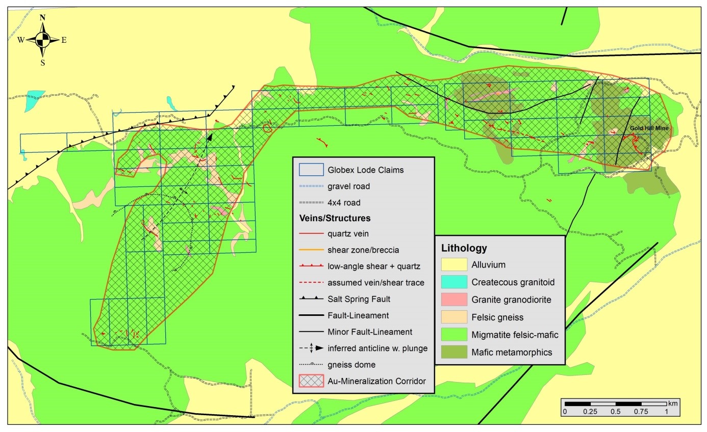
Geologic map of the northern Gold Basin District depicting the northern Gold Corridor, major and minor faults/lineaments, auriferous gold veins and Globex’s Salt Spring claim blocks (West and East).
Property Mineralization
In the Salt Spring project gold mineralization appears to be controlled by a complicated interconnected system of steep and shallow dipping faults, shears and breccias in close relationship to granitic stocks, dikes and sills. It is indicated that gold orebodies are associated to- or hosted in small-scale faults that are different in orientation from the regional faults. In general most auriferous quartz veins have a NW-SE strike meanwhile most regional faults (Salt Spring Fault & White Elephant Fault) trend SW-NE. It is suggested that sinistral movement along the regional SW-NE faults has led to many small-scale subsidiary faults and fractures with subsequent gold mineralization.
In summary gold mineralization in the Salt Spring project occurs in the following geological environments:
- In steeply dipping (> 45°) mesothermal buck quartz veins, with or without significant epithermal quartz overprint. Rarely exclusively in epithermal quartz veins.
- In flatly dipping to sub-horizontal shear zones together with abundant (buck, less epithermal) quartz veining (example is Gold Hill mine).
- In flatly dipping to sub-horizontal manto-like shear/breccia zones with little, occasionally without any quartz veining (for example North mine).
- In carbonate (ankerite-siderite) – sericite – (pyrite) altered wallrock with or without quartz veinlets/stockwork attached as envelopes to auriferous quartz veins.
- Disseminated gold in breccias (partly polymict) and weakly to strongly sheared-foliated gneiss/granite with pervasive sericite-carbonate-(oxidized sulphides) alteration, locally minor mesothermal quartz veinlets and silicification may appear. Major auriferous mesothermal buck quartz veins are absent.
- In coarse grained to pegmatitic granite dikes or feldspar-dominated pegmatite dikes affected by locally intense replacement with coarse crystalline pyrite (oxidized to limonite/hematite). These zones may assay several g/t in gold.
- Disseminated in gneiss, lacking faulting and macroscopically visible alteration.
Globex’s exploration activities 2023-2025
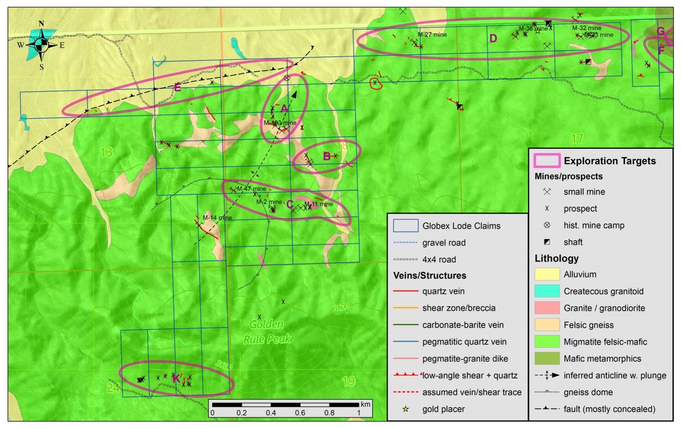
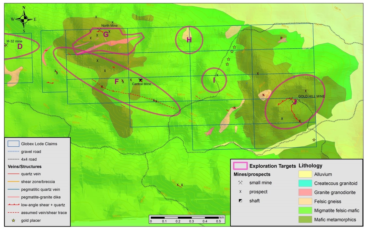
Globex had carried out preliminary fieldwork in both claim blocks, including geological mapping and collected a total of 111 surface- and underground rock samples between 2023 and 2025. Most samples had been collected from historic workings and mine dumps. Based on geology and assay results Globex outlined at total of 11 promising gold target zones, targets A to D & K in the West Claim Block and targets F to J in the East Claim Block. A summary of selected assay results of these rocks samples is given in the below table:
Selected Assay Results Salt Spring Project, Rock Samples (2023-2025)
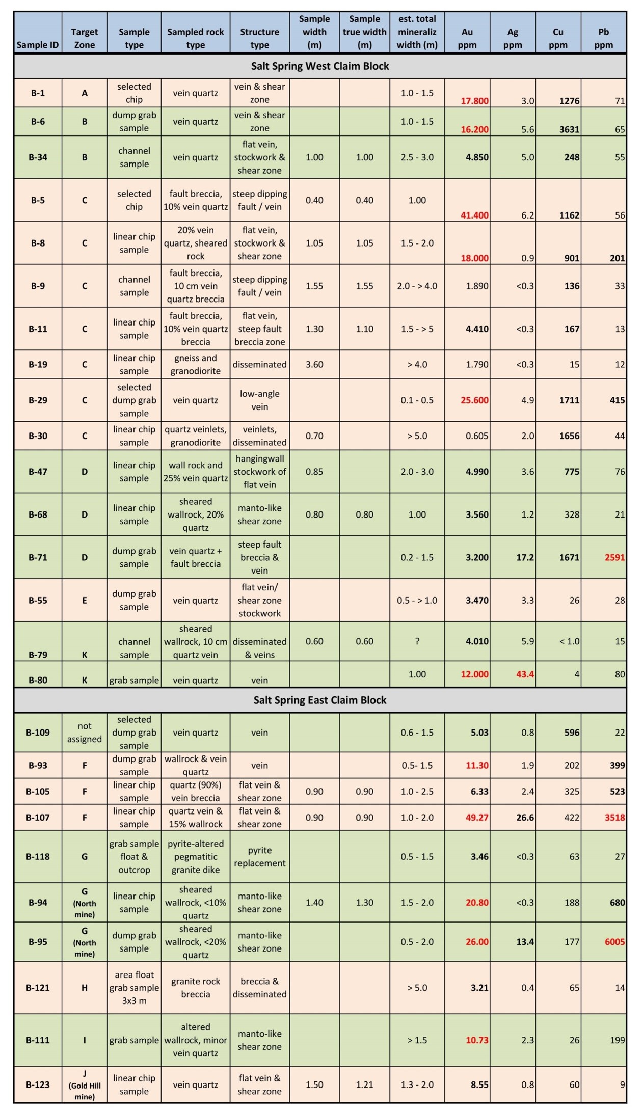
Note: Grab samples and chip samples are selective by nature and are unlikely to be representative of average grades. Conversion 1ppm =1g/t
Geological Map of Salt Spring West Claim Block with Exploration Target Zones.
Geological Map of Salt Spring East Claim Block with Exploration Target Zones.
Globex’s most recent exploration activities
Latest exploration efforts (Nov. 2025 to Jan. 2026) lead to the discovery of several low- and high-grade gold occurrences, that had not been recognized in the past (no historic prospect or mines).
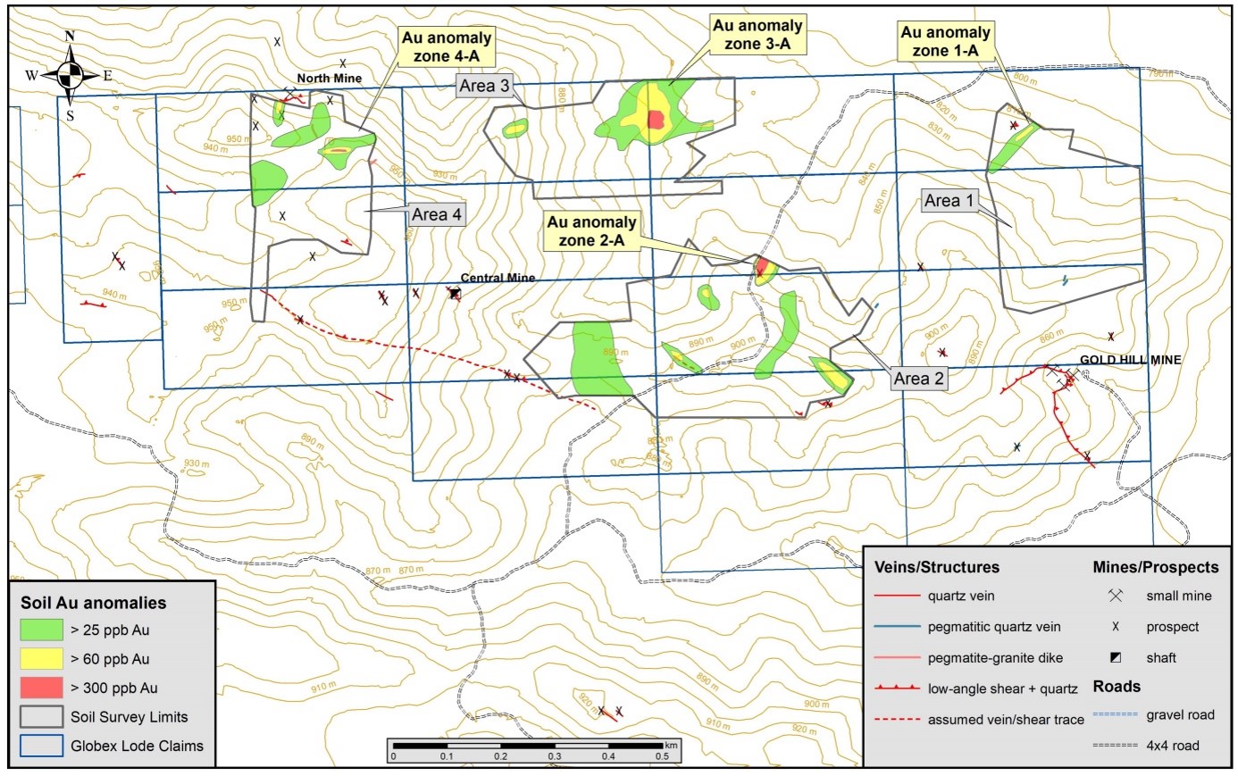
Following a positive test soil survey a comprehensive geochemical soil survey was executed in November 2025. A total of 331 soil samples had been collected in four selected areas of the East Claim Block. Assay results for soil samples ranged between less 3 ppb Au (detection limit) to a maximum value of 909 ppb Au (0.9 g/t Au). Gold values of soil samples above 25 ppb are considered as anomalous and could be related to gold mineralization concealed under shallow overburden. Most significant gold in soils anomaly zones were zones 2-A, 3-A and 4-A.
Anomaly zone 2-A is associated to high-grade gold mineralization that is source for a small eluvial placer gold deposit in a gulch to the northeast. Rock grab sample B-111 had been collected already here in March 2025, it returned 10.73 ppm Au.
Anomaly Zone 3-A (formerly exploration target zone H) is considered as the most striking target discovery of the entire Globex claim block so far. The gold in soil anomaly > 25 ppb measures 220 m in E-W and 120 m in N-S direction. A central zone with highly anomalous gold values > 60 ppm measures 110 m in N-S and 90 m in E-W direction. In the core of the anomaly zone three soil samples returned very high gold values (353 ppb, 496 ppb and 828 ppb Au), encompassing a circular area with a diameter of about 30 m. Anomaly 3-A could point toward a larger gold deposit present below shallow overburden.
Anomaly zone 4-A is spatially linked to the southern margin of a large ENE trending granite dike. The anomaly (>25 ppb) is about 100 m long (open to E) and up to 90 m wide. The highly anomalous core zone (2 soil samples), returning up to 411 ppb Au in soil, is about 50 m long.
Globex’s Salt Spring East Claim Block with Gold in Soil Anomaly Zones
For investigating the outlined gold in soil anomalies follow-up fieldwork, including trenching by hand, rock sampling and geologic mapping was performed in January 2026. A total of 39 rock samples had been collected from trenches and outcrops; all are channel samples and linear chip samples (the latter only in very resistant bedrock). In the following only a description of two discovered gold occurrences:
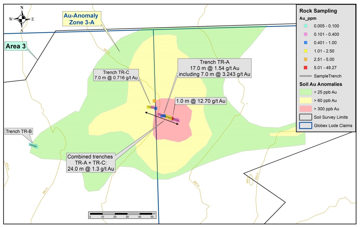
Zone 3-A: Geology is characterized by mostly felsic migmatite gneiss that had been intruded by numerous dikes and sills of leucocratic granite exhibiting locally foliation (post-orogenic shearing) and pervasive sericite-ankerite alteration is common. Three trenches had been excavated by hand. Trench TR-A is centred on the highest gold in soil anomaly zone; it is orientated WNW-ESE and 17 m long. Bedrock at the bottom of the trench include granite, a coarse polymict clast-supported breccia, faulted/sheared gneiss with carbonate-sericite alteration, fault/shear breccias (partly silicified) with minor mesothermal vein quartz and a bit of limonite. A total of 16 channel and linear chip samples had been collected continuously from east to west. All samples assayed gold values and the (weighted) average over the entire trench length of 17.0 m is 1.54 g/t Au. A higher grade interval of 7.0 m length (between 5.0 and 12.0 m) assayed 3.243 g/t Au. Highest grade channel sample B-139 returned 12.70 g/t Au over 1.0 m length. Mineralization remains open to the ESE. Displaced by 5.0 m to the NW had been excavated trench TR-C over a length of 7.0 m; it is also orientated WNW-ESE. A total of 6 samples had been collected continuously from east to west. All samples assayed gold values and the average over the entire trench length of 7.0 m is 0.716 g/t Au. Highest grades returned the two westernmost samples (each 1.0 m long) B-163 and B-164 with 1.01 and 2.18 g/t Au respectively. Consequently gold mineralization remains also open to the west. Both trenches TR-A and TR-C can be put together and averaged as one sample line, resulting in a total length of 24.0 m and an average grade of 1.30 g/t Au. Gold mineralization remains open to both sides. At the western edge of gold anomaly Zone 3-A, 95 m to the WSW of the western end of trench TR-C, had been excavated trench TR-B over a length of 5.65 m. A total of 5 samples had been collected here, lacking any significant gold values.
Trenching and assay results confirm that the large gold in soil anomaly Zone 3-A is associated to a low-grade gold zone (with local high-grade) with a minimum width of 24.0 m, open to both sides. Shape, dimensions and dip of this mineralized zone are not known, however it is indicated that it trends roughly N-S or NW-SE dipping perhaps 50° west. Trenching and sampling did not expose the entire widths of this gold zone; it could approach a total width of up to 50.0 m.
Close-up map of Gold in Soil Anomaly Zone 3-A, Trenches & Assay Results
Zone 4-A: It is spatially associated to an about E-W trending steeply dipping fault/shear zone hosted in a wide granite dike. Hand-dug trench TR-D is orientated SSW-NNE, it is 13.0 m long and was sampled over two separate segments totaling a length of 9.60 m. A total of 7 channel and linear chip samples had been collected from south to north. Sampled interval between 8.00 and 10.60 m (B-168 to B-170) assayed 6.212 g/t Au over 2.6 m length. Highest grade returned channel sample B-170 with 13.1 g/t over 0.6 m length. Mineralization is associated to a fault/shear breccia containing a bit of mesothermal quartz. Attached to the high grade structure are envelopes of very low grade gold mineralization. The mineralized shear zone could continue to both sides; to the west it enters a dry creek covered by boulders and gravel, to the east it is concealed under shallow slope scree. An eastward continuation of this fault/shear zone connecting to the large anomaly Zone 3-A appears possible.
History
In the West Claim Block of Globex’s Salt Spring property have been identified 19 small mines and at least 54 prospects. A small historic mine camp was discovered in the central northern part. Surface finds (tins, glass, pottery) suggest a period of earliest mining activity between 1905 and 1914.
In the East Claim Block is located the historic Gold Hill mine, the small North mine, Central mine and about 22 small prospects, cuts or workings. Although the largest mine in the northern Gold Basin region, the Gold Hill mine was a rather small operation with intermittent production between 1930 and 1942. According to 1940 summary report there exist two tunnels 55 m and 18 m in length and one inclined shaft to 12 m depth. Mine depth could have been increased in the years 1941 to 1942. Certainly a few thousand tons must have been extracted from the mine considering the size of underground mine workings and mine dump (about 2000 tons). Old reports to past production are limited to a note that says 359.57 t averaging 21.7 g/t Au in 1940.
In the 1980s the Hecla Mining Company explored and drilled (1987/88) the Gold Hill mine and returned the leased property to the owners in 1988. The best intercept was 8.22 m assaying 5.3 g/t Au.
The Canadian explorer Usha Resources conducted limited exploration at their Lost Basin and Gold Basin property in 2020/21. They also controlled the Gold Hill mine region until 2023.
Resources and Potential
With the current level of early-stage exploration data no resource calculation can be given. Based on collected rock samples, the discovery potential for moderate- to high grade vein- and stockwork hosted gold mineralization at the different targets should add up at least to several hundred thousand tons.
Most recent (2025/26) follow-up soil and rock sampling lead to the discovery of previously unknown high- and low-grade gold mineralization zones (without historic prospects or mines) in the Salt Spring East Claim Block. Some of those could be related to larger (possibly exceeding 1 million tons) low-grade disseminated gold mineralization.
Recommended follow-up exploration work is as follows:
- Further soil sampling in the East Claim Block and extensive soil sampling in the yet untested West Claim Block.
- A comprehensive trenching and rock sampling campaign, focusing on outlined gold in soil anomalies, should follow the recommended geochemical soil survey expansion.
- Preparation of drill programs (enough data already exist for Gold Hill mine and target zone 3A).
- A remote multi-spectral analysis for definition of alteration zones related to gold mineralization.
- Several lines of IP-resistivity survey across target zones containing disseminated pyrite with associated gold mineralization in the northern East Claim Block are recommended.