
BM Property
Location, Access, Description
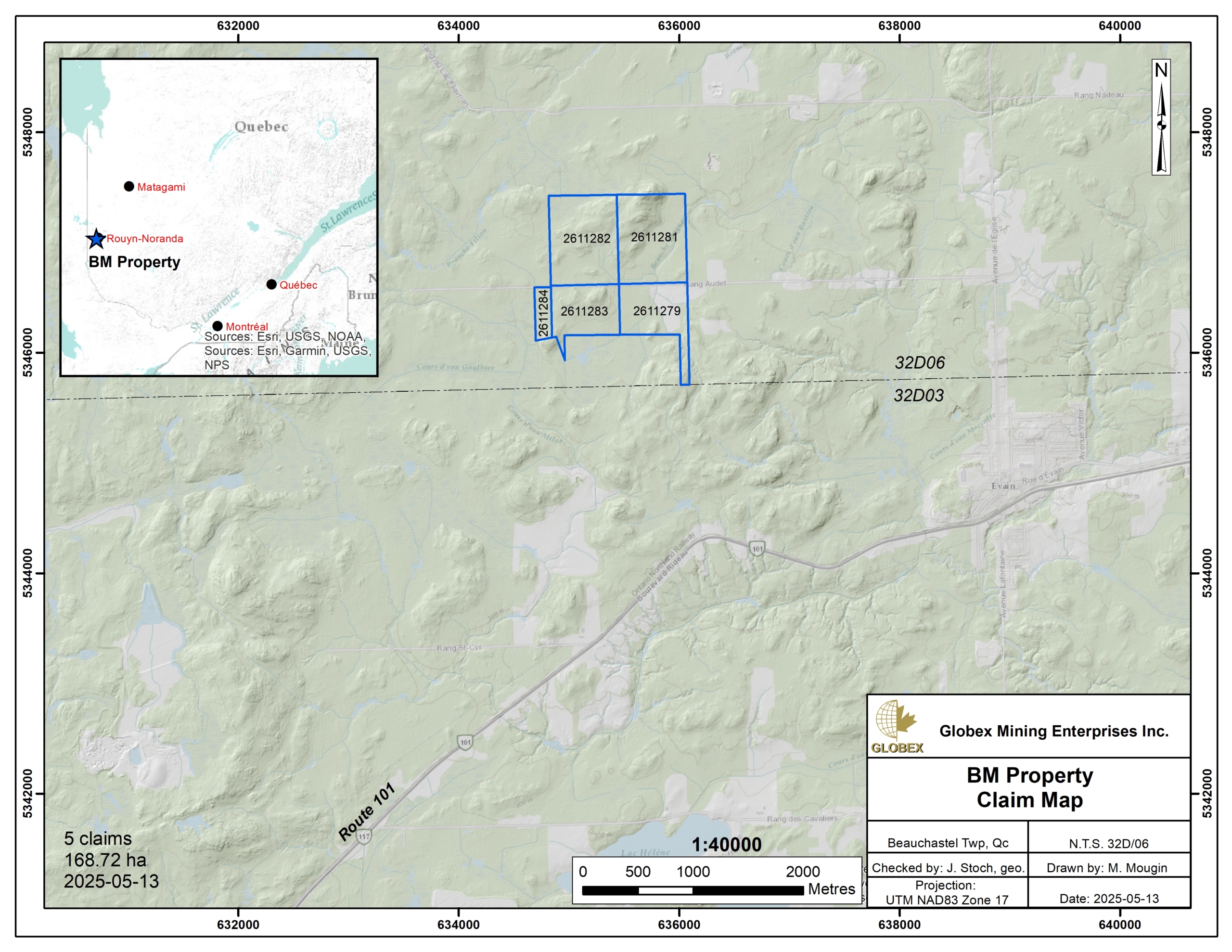
The BM property is located in the Abitibi-Temiscamingue region of Quebec Province. It is composed of 5 contiguous mining cells totalling 169 ha in Beauchastel township (NTS 32D06), about 10 km west of the town of Rouyn-Noranda. The claims are fully held by Globex and are not subject to any third-party interests.
The property is easily accessible by road from Rouyn-Noranda. One thus needs to drive on Highway 117 N to Evain, then drive north on Avenue de l’Eglise about 2.1 km, and finally take west on Range 8-9 road for about 2.9 km.
Numerous commodities can be found in Rouyn-Noranda regarding contractors, skilled labor, equipment rental, as well as sleep and food accommodation of remote workers, even a smelter. Several Hydro power line are located in the vicinity of the property.
The property is located on private lands. Land owner’s authorization is required prior to carry out any exploration work.
Geology and Mineralization
Regional Settings
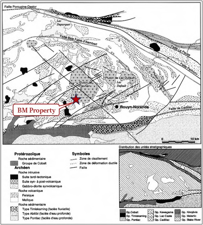
The property is located in the Abitibi Sub-province of the Canadian Shield. The Abitibi Sub-province is formed of Archean volcanic and sedimentary rock assemblages deposited between 2,730 and 2,690 Ma (Chown et al., 1992; Daigneault et al., 2002) injected by large masses of intermediate to felsic plutonic rocks. All these lithologies were deformed and verticalized during the Kenorean orogeny that occurred about 2.7 Ga ago (Percival et al., 2006; Percival, 2007). Regional metamorphism is at the greenschists grade and locally reaches the lower amphibolite grade around large Archean intrusions.
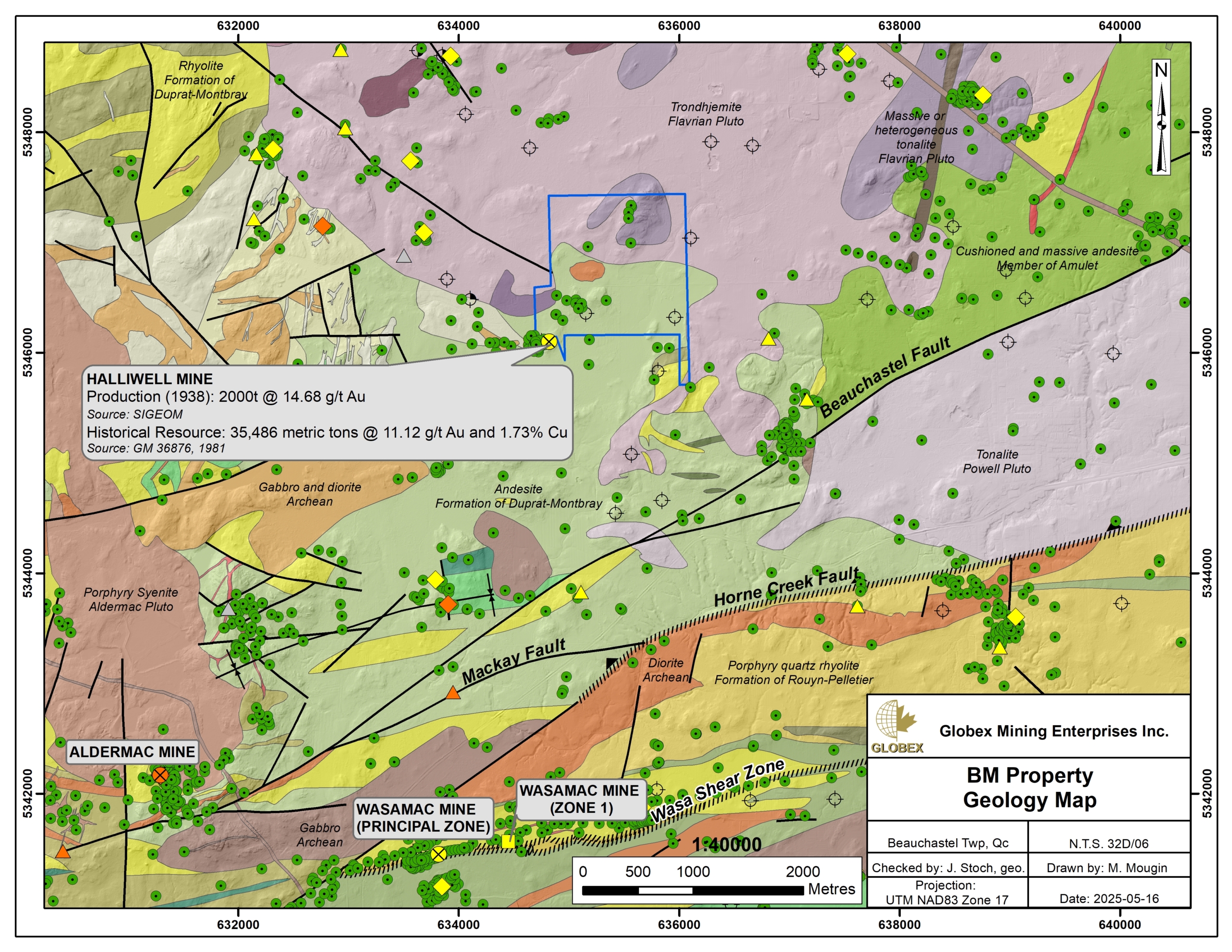
Several regional structural features are listed in the property area ; those include the Beauchastel Fault, the Horne Creek Fault (HCF), the Wasa Shear Zone (WSZ) and the Cadillac Larder-Lake (CLL) Fault. Each of these structures is associated with gold and base metal showings and deposits.
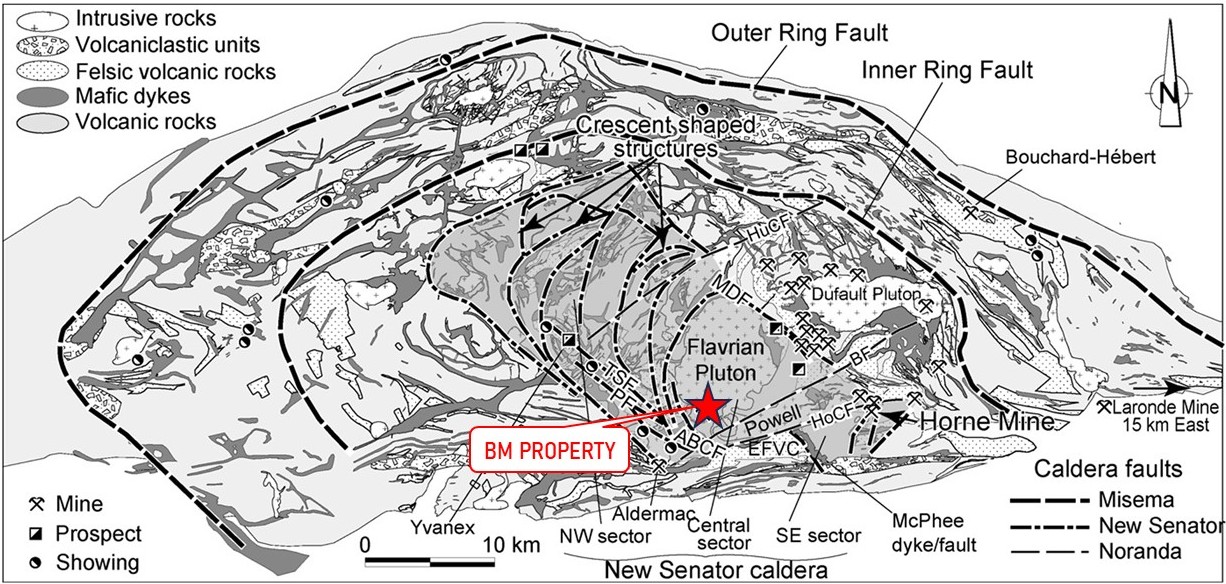
In the BM property area, rocks of the Abitibi Sub-province belong to the Blake River Group (2,701 – 2,696 Ma; Lafrance et al., 2005) which is defined as a bimodal calk-alkaline and tholeiitic subaqueous megacaldeira (Pearson and Daigneault, 2009) whose main characteristics are: 1) radial and concentric arrangement of mafic and intermediate synvolcanic dykes, 2) Dome geometry of the volcanic strata and 3) internal and external ring-shaped synvolcanic faults between which are distributed complexes of volcanoclastic rocks as well as a regional alteration in carbonates (MB2009-19). The superstructure is formed of at least three distinct and embedded caldeiras (Misema, New Senator and Noranda).
The Noranda Caldera corresponds to the final collapse of the volcanic system. This event produced a N070° oriented graben structure that is delimited by the Horne Creek and Hunter Creek faults. In the Blake River Group (BRG), most of the volcanogenic massive sulphide (VMS) deposits are located in the Central Camp and are strongly linked to the evolution of this caldera (MB2009-19).
Property Geology
The area of the BM property features a major felsic volcanic center known as the “West Flavrian Volcanic Complex”. This sequence is cut by various gabbro-diorite dykes and sills, as well as late-tectonic lamprophyre dykes and Proterozoic diabase-gabbro dykes. Numerous outcrops can be observed throughout the west half of the property.
The BM property consists mainly of intermediate intrusive rocks of the Flavrian Pluton, accompanied by intermediate tholeiitic and transitional volcanics of the Duprat-Montbray Formation. The stratigraphic stacking forms a homoclinal sequence oriented N-S to NE-SW with a dip varying from 40° to 70°. The stratigraphic tops of the units face east (ET2007-03).
The Flavrian Pluton lies within the volcanic pile represented by the Blake River Group, in line with the regional foliation (Rive, 1994). Seismic data revealed that the Flavrian Pluton forms a gently east-dipping subconcordant sill intruded into calc-alkaline units of the Blake River Group (MB96-06). Kennedy (1984) demonstrated that the Flavrian pluton is a complex composite intrusion comprising at least 5 successive intrusive phases.
Regional Metallogeny
The Rouyn-Noranda area is rich in metallic deposits. Since the discovery of the Horne deposit in 1927, mineral resources have been mined from more than 42 mines, including several world-class ones. The region of the BM property contains at least three types of mineralization : 1) volcanogenic massive sulfide (VMS) Cu ±Zn ±Au+Ag mineralization that occurs as disseminations, veinlets or exhalative horizons ; 2) magmatic-hydrothermal mineralization that is mainly related to intrusive and hydrothermal breccia zones ; and 3) orogenic gold mineralization that occurs as weakly pyrite-mineralized quartz + carbonate veins and veinlets.
The Cadillac – Larder Lake fault strikes about 7 km south of the BM property in a roughly E-W direction. This regional structure represents one of the most important gold metallotects in the Abitibi Sub-province and hosts numerous deposits > 100t Au (Kirkland Lake, Kerr-Addison, Sigma-Lamaque, Malartic…).
The Francoeur-Wasa shear zone strikes about 5 km south of the BM property and it is also associated with first-class gold deposits including the former Francoeur mine and Wasamac deposit.
Most of the VMS deposits of the Rouyn-Noranda mining district are located in the Central Camp and are strongly linked to the evolution of the Noranda caldera. Faure (MB2009-19) observed a strong relationship between VMS deposits and some orientations of faults and mafic dykes in the BRG. Most of N050°-N090° and N090°-N135° faults are interpreted as synvolcanic structures. The N050°-090° fault system at Central Camp is unique to the BRG and is aligned elsewhere in Abitibi with other synvolcanic faults (MB2009-19).
Property Mineralization
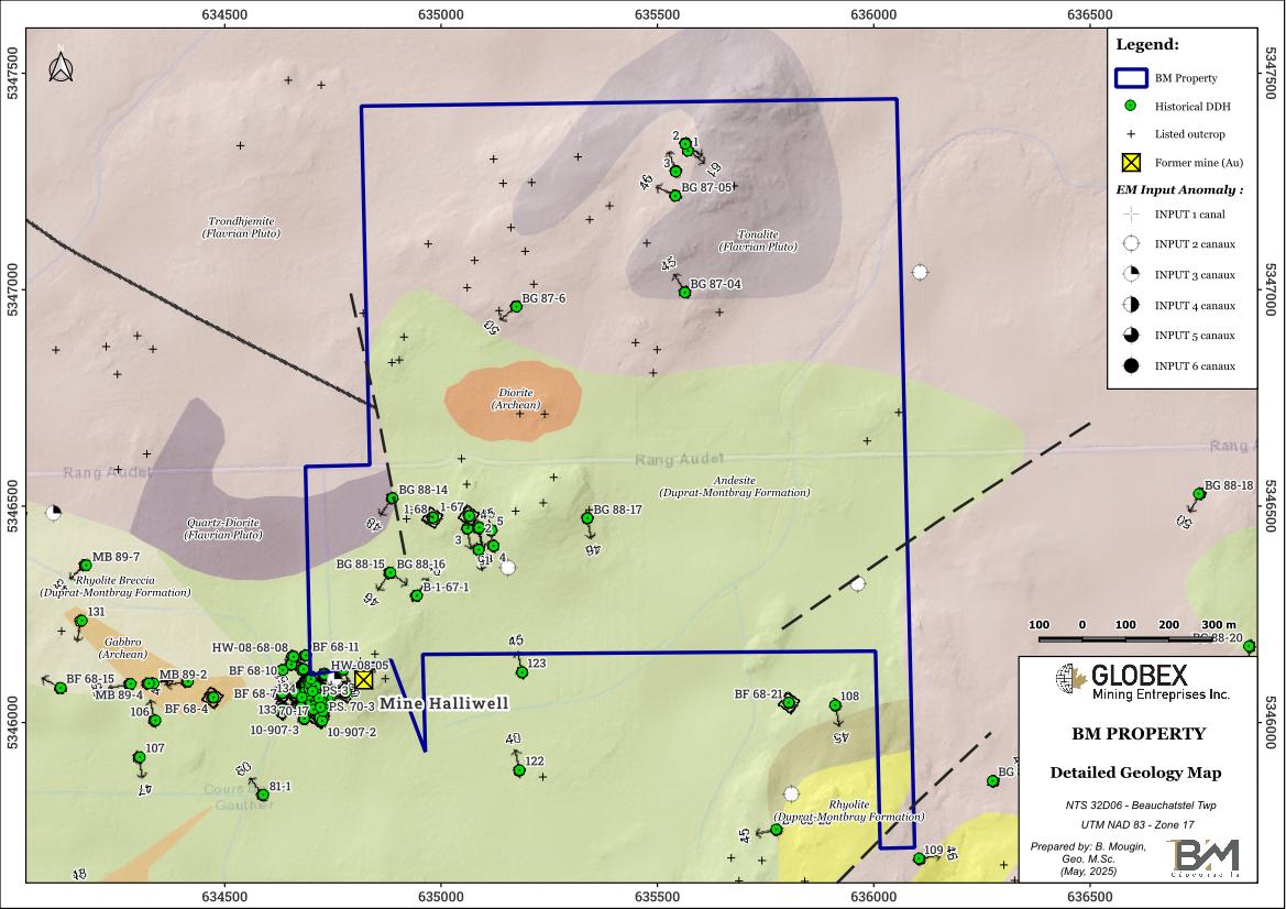
No metallic occurrence has been uncovered yet on the BM property by historical work but several historical DDH returned highly anomalous intervals with assays up to 0.82 ppm Au over 0.80 meters (BG-87-05) and 2.63 ppm Au and 0.17 ppm Ag over 1.00 meters in BG-88-15. Gold mineralization is associated with hematized quartz veins intruding a silicified tonalite, and associated with 2% disseminated pyrite in both quartz and hostrock.
Numerous gold and base metals showings and deposits have however been identified in the vicinity of the BM Property, following the contact zone between the Flavrian Pluton and the volcanics and frequently associated with ENE and ESE faults. These two conditions are fortunately observed on the BM property.
The Halliwell Mine (Historical production of 2000t @ 14.68 g/t Au – Sigéom) is located right south of the BM property. This gold-copper deposit contains two distinct mineralized horizons: a near-surface copper zone and three gold-copper zones between 80 m and 130 m. Mineralization is controlled by a fault zone. The chloritized andesite contains fine chalcopyrite and pyrite flakes, with locally massive chalcopyrite in veinlets and lenses several centimetres long. The best gold intervals are located in contact with the Flavrian Pluton.
History
Following the discovery of the Halliwell deposit in 1925, numerous exploration work were carried out on the BM property area by previous owners, including prospection, geological mapping, stripping, channel-sampling, geophysics and diamond drilling (DDH). Table 2 below presents a brief summary of historical work in the BM property area :
Table 2 : Summary of historical work in the vicinity of the BM property.
| Year | Company | Work carried-out |
| 1926-1938 | Halliwell Gold Mines Ltd. | Extensive exploration programs on the Halliwell deposit, including geological mapping, trenching, geophysics and mlore than 12,000 meters (40,000 ft) of DDH. The Halliwell shaft is sunk in 1937 at a depth of 151 m (496 ft). In 1938, about 3,000 metric tons of ore grading 14.8 g/t Au were extracted. |
| 1946 | Abénakis Mines Ltd. | Mag survey and above 6,700 m of DDH (34 holes). |
| 1967-1968 | Noranda Exploration Ltd. | Mag, EM and IP surveys, 23 DDH (above 2,700 m). Some weak Au anomalies in DDH. |
| 1970 | Carpaul Mines Ltd. | 3 DDH (63.4 m) |
| 1970 | Eskimo Mines Ltd. | 20 short DDH (700 m) on a copper showing located just west of the Halliwell shaft. |
| 1973 | Jupiter Development Corp. | Dewatering of the Halliwell shaft and 12 DDH (325 m) |
| 1979-1982 | SOQUEM | Geological mapping, Geochemistry, DDH compilation, DDH (805 m, 4 holes), in-hole VLF-EM survey. |
| 1987-1988 | Noranda Exploration Ltd. | 7 DDH on the BM property (BG-87-04 to 87-06 and BG-88-14 to 88-17). GM46705 and GM48838. |
| 1988 | Barrick Gold Corp; | Mag and VLF-EM surveys, 7 DDH (1,756 m) |
| 2000-2001 | Aurogin Resources Ltd. | Heli-borne AEROTEM survey and ground follow-up |
| 2008 | Bull’s Eye Inc. | DDH program of 882.2 meters of core (10 holes) in order to confirm historical assays in the vicinity of the Halliwell Mine. Presence of Au and Cu mineralizations was highlighted in several DDH. The best intersections in 2008 drilling (GM65370) include 1.42% Cu over 24.99 m (HW-08-68-03); 0.72% Cu and 1.81 g/t Au over 32.36 m including 3.81% Cu, 2.80 g/t Au over 2.44 m and 8.89% Cu, 49.70 g/t Au over 0.91 m (HW-08-03B). |
Resources and Potential
The geological context of the BM property, located on the contact between archean volcanics and the Flavrian synvolcanic Pluton, is strongly favorable to the discovery of both gold and base metals mineralization. Historical DDH on the BM property returned assays up to 0.82 ppm Au over 0.80 meters (BG-87-05) in the northeast of the property, and up to 2.63 ppm Au and 0.17 ppm Ag over 1.00 meters (BG-88-15) in the southwest of the BM property. Gold mineralization in historical DDH is generally associated with quartz veins and veinlets in silicified and hematized tonalite of the Flavrian Pluton accompanied by up to 2% disseminated pyrite.
Previous work has also identified numerous gold and base metal showings in the area of the BM property, as well as favorable geological and structural features for the emplacement of both gold and base metal mineral deposits. One of the most researched metallotects for VMS exploration in the Noranda Central Camp is the presence of synvolcanic faults. Research work on VMS fertile synvolcanic faults in the Blake River Group (BRG) by the CONSOREM in 2009 (MB2009-19) highlighted that most fertile faults are associated to the N070° synvolcanic hydrothermal system. Several criteria for recognizing synvolcanic faults are presented by Gibson et al. (1997), including:
– Intensification, unconformity and abrupt changes in hydrothermal alteration;
– Abrupt changes in thickness along volcanic units or net termination of units
– Presence of coarse, localized volcanic breccias discordant with the units (Franklin, 1993); fragmentary, foliated or schistose rocks; and quartz veins, stockwerks and sulfide veinlets;
– Rhyolitic domes (Dimroth et al. 1978);
– Unfaulted units overlying faulted sequences;
– Networks of dykes or apophyses linked to synvolcanic intrusions;
– Changes or ruptures in the direction and/or dip of volcanic units.
In the GBR, the vast majority of faults dip steeply, generally more than 70°, particularly in the Central Camp (Gibson 1983; Gibson and Watkinson 1993).
Future work on the BM property should include a compilation of historical geophysical data in order to verify for the presence of secondary faults on the property, like the ones which are interpretedon the detailed geology map above. The VLF-EM method is particularly suitable for this purpose. Particular attention should be paid to the N070° orientation, following recommendations of Faure (MB2009-19). Depending on the amount of historical data available and usable, further geophysical surveys (Mag, VLF-EM, IP) should be considered.
Compilation of historical data should try too, to locate historical trenches in order to refresh and re-sample them.