Bousquet
Location, Access, Description
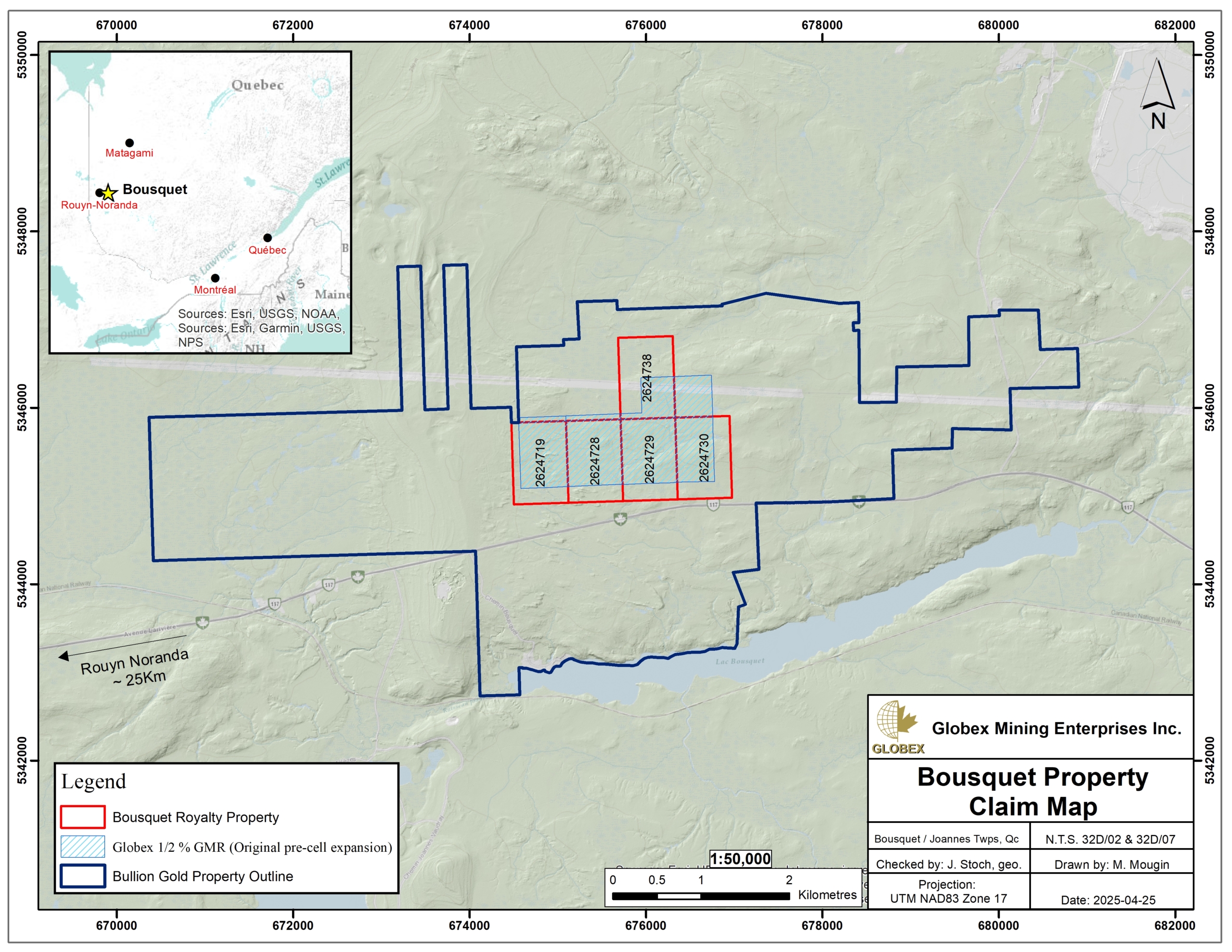
The Bousquet property consists of 5 mining claims covering an area of 286.79 Ha in the Bousquet township, MRC of Rouyn-Noranda, approximately 25 km east of Rouyn-Noranda (Qc). The claims are now wholly owned by Bullion Gold Resources Corp., but Globex retains a 1/2% Gross Metal Royalty (GMR).
The property is accessible by road, driving on Highway 117 from Rouyn-Noranda or Val-d’Or. Gravel roads and trails run through the property. Remote workers can be accommodated with all food and sleep facilities in Rouyn-Noranda, where shopsandcontractors are available as well.
The property displays gentle relief with elevation generally 300m to 325m above sea level. Vegetation coverage on the property consists mostly of Black Spruce forest with several moderately sized areas of swampy terrain. The northernmost claims are traversed by an east-west trending powerline.
Geology and Mineralization
Regional Settings
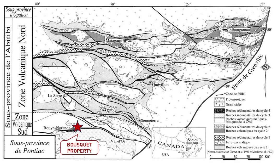
The rocks of the Bousquet area lie within the southern part of the Superior geological Province and belong to the Abitibi (greenstone belt) Sub-Province. The Abitibi Subprovince is an Archean greenstone belt which consists of volcanic and sedimentary rock assemblages injected by intermediate to felsic plutonic rocks (Goutier and Melançon, 2010). Rocks of the Superior Province have been deformed during the Kenorean Orogeny between 2.72 Ga and 2.68 Ga (Percival et al., 2006; Percival, 2007). The Abitibi Subprovince is characterized by heterogeneous deformation with strongly deformed zones alternating with zones of little or no deformation. Regional metamorphism is of the greenschist facies, however contact metamorphism near the granitic intrusions is of the albite-epidote amphibolite facies.
The Abitibi Greenstone Belt (ABG) has traditionally been subdivided into two domains roughly separated by the Destor-Porcupine fault zone: the North Volcanic Zone (NVZ) comprises volcanic rocks that were mainly emplaced between 2,730 Ma and 2,705 Ma, while the South Volcanic Zone (SVZ) is characterized by the presence of younger volcanic rocks, essentially between 2,700 Ma and 2,690 Ma in age (Chown et al., 1992; Daigneault et al., 2002). The Destor-Porcupine fault zone is sometimes interpreted as the location of a north-dipping Archean subduction zone, separating the ZVN from the ZVS (Daigneault et al., 2002). The lack of evidence for significant thrusting led Thurston et al. (2008) to interpret the stratigraphic assemblages of the AGB as sequences of deformed autochthonous rocks.
The Abitibi Subprovince is bounded from the Pontiac Subprovince to the south by the Cadillac tectonic zone. The Pontiac consists mainly of 2,685 Ma to 2,672 Ma (Davis, 2002) old turbidites metamorphosed to the greenschist grade near the contact with the ABG and to the amphibolite grade further south.
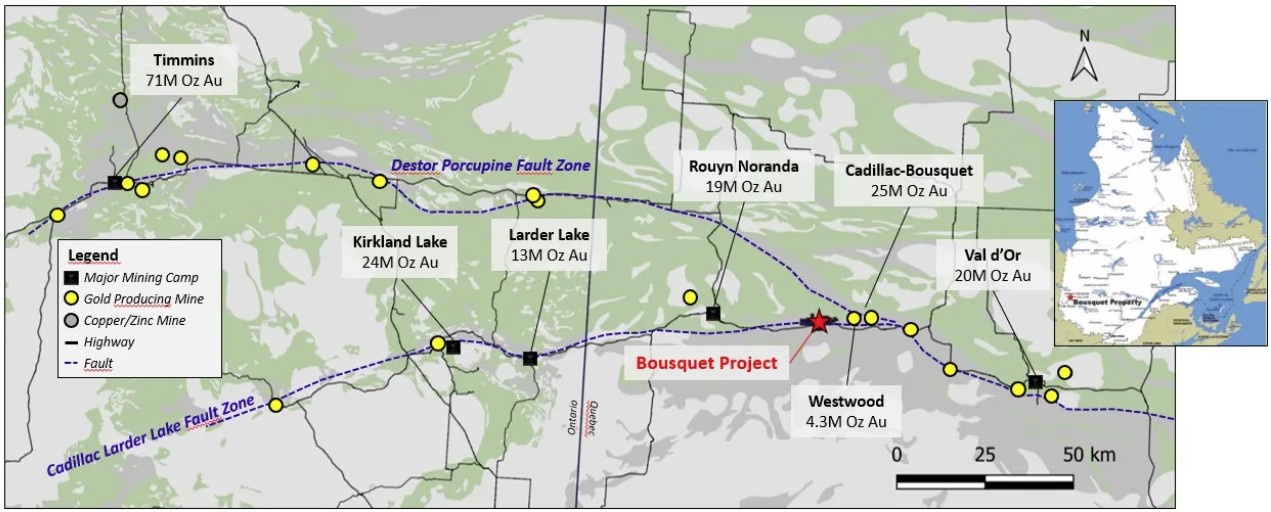
The AGB hosts some of the richest mineral deposits of the Superior Province. About 210 Moz Au (6,500 t) have been extracted from more than 120 different mines in the Abitibi Subprovince since early 20th century (P. Dumas, RMI Magazine, January 2024, pp. 7).
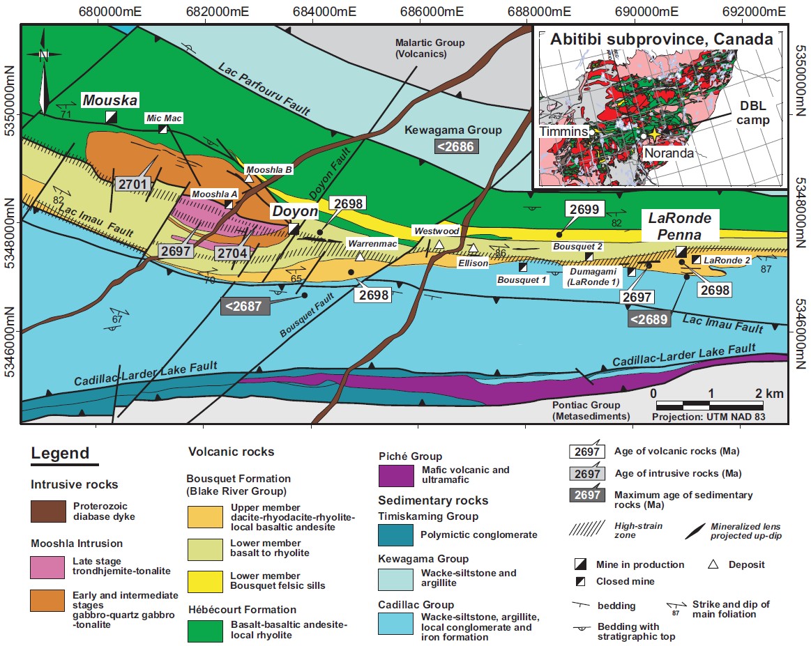
The Doyon-Bousquet-LaRonde (DBL) mining camp is an approximately 10 km long, east-west-trending succession of volcanic rocks located 45 km east of Rouyn-Noranda. The DBL mining camp is located in the eastern part of the Blake River Group in the Southern Volcanic Zone of the Archean Abitibi greenstone belt, between the Cadillac-Larder Lake fault zone to the south and the Lac Parfouru fault to the north. All lithologies of the DBL mining camp has been affected by a north-south compression event, which resulted in a sub-vertical to steeply south dipping homoclinal volcanic sequence with an east-west schistosity.
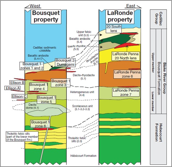
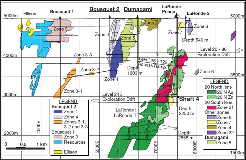
The Blake River Group is restricted in this area to a narrow eastwest-striking, south-facing homoclinal volcanic sequence between sedimentary rocks of the <2686 Ma (Davis, 2002) Kewagama and the <2687 Ma (Lafrance et al., 2005) Cadillac Groups. Rocks of the DBL camp represent the upper part of the 2,703 to 2,694 Ma Blake River Group (Péloquin et al., 1990; Barrie et al., 1993; Mortensen, 1993; Ayer et al., 2002; Lafrance et al., 2005) ; most of the deposits are located within the ~2,699 to 2,696 Ma Bousquet Formation which is one of the youngest volcanic packages within the Blake River Group (Dubé et al., 2014). In terms of tonnage, the DBL camp ranks amongst the largest Canadian VMS districts (Galley et al., 2007) and first among the Au-rich VMS districts subtype (Gosselin and Dubé, 2005; Dubé et al., 2007). Four of the largest Au-rich VMS mines known in the world are located in the DBL camp (Bousquet 1, Bousquet 2, Dumagami, and LaRonde Penna).
Property Geology
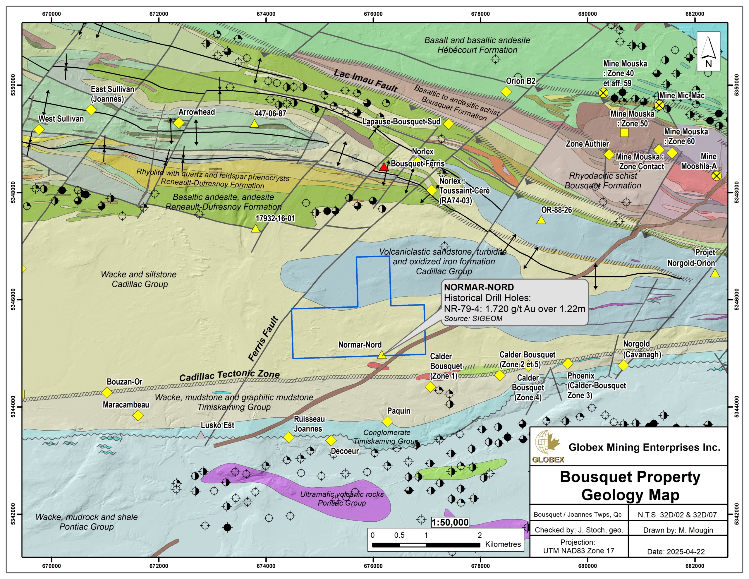
The Bousquet property is located immediately north of the Cadillac tectonic zone which separates the Pontiac Subprovince to the south from the Abitibi Subprovince to the north. Very few outcrops are present on the property. Rocks of the property belong to the Cadillac Group and they are mainly composed of greywacke, sandstone, turbidites and oxide-iron formations. Structural measurements taken in several places show that the bedding within the greywackes have a consistent strikes of about 260° to 265° and dips very steeply to the north (GM49102). The local foliation is weak, strikes about 286° to 300°, and dips steeply to the north.
One single hole (TMN-03-29) has been drilled near the south border of the property and intersected intercalated siltstone and greywacke and several narrow diabase dykes (GM61411). The drill hole then cut a diabase dyke from 178m to 279m. Below the diabase dyke greywacke and siltstone were intersected. No significant sulphide rich or silicified zones were encountered. The assay results indicated only background levels for gold.
A ENE-oriented diabase dyke crosses the southeast part of the Bousquet property in the area of the Normar-Nord Au showing.
Regional Metallogeny
Information of the present section is taken from Mercier-Langevin et al., 2007 (Metallogeny of the Doyon-Bousquet-LaRonde Mining Camp, Abitibi Greenstone Belt, Quebec), and Dubé et al., 2014 (The Bousquet 2-Dumagami World-Class Archean Au-Rich Volcanogenic Massive Sulfide Deposit, Abitibi, Quebec: Metamorphosed Submarine Advanced Argillic Alteration Footprint and Genesis).
The Doyon-Bousquet-LaRonde (DBL) mining camp is the largest gold-copper-zinc-silver producing district in the province of Quebec. DBL deposits are hosted by the volcanic and intrusive rocks of the 2701-2696 Ma Bousquet Formation located in the upper part of the 2703-2694 Ma Blake River Group in the Abitibi greenstone belt. Three main Au ±Cu-Zn-Ag deposit types are recognized in the DBL mining camp: 1) Au-rich volcanogenic massive sulphide deposits (LaRonde Penna, Bousquet 2-Dumagami, Bousquet 1, Westwood, Ellison, Warrenmac); 2) Epizonal ‘intrusion-related’Au-Cu sulphide-rich vein
systems (Doyon); and 3) Shear zone-hosted (‘orogenic’) Au-Cu sulphide-rich veins (Mouska, Mic Mac, Mooshla), which share some characteristics with the first two ore types.
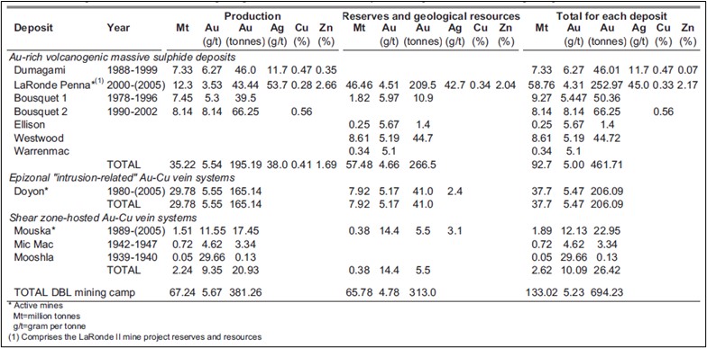
Since the 1930s, mining has taken place at eight Au ± base metal deposits in the DBL camp for a cumulative production, at the end of 2005, of 67 million tonnes (Mt) of ore at an average grade of 5.67 g/t Au (381 tonnes (t) Au, equivalent to 12.3 Moz Au). Significant amounts of Ag and base metal also have been produced in the camp since 1999 from the LaRonde Penna deposit.
Despite the fact that most of the reserves and estimated resources in the camp are hosted in VMS deposits, about half of the Au produced in the camp comes from vein-type deposits (Doyon, Mouska, Mic Mac, and Mooshla A). Although LaRonde Penna is a VMS deposit, its Au content, in grams per tonne, exceeds that of the combined base metal content in weight percent, and therefore corresponds to the classification proposed by Poulsen et al. (2000) for Au-rich VMS deposits. Numerous other deposits of the DBL camp are also considered Au-rich VMS deposits: Bousquet 1, Bousquet 2-Dumagami, Westwood, Ellison, and Warrenmac.
Data presented in Table 1 (attached below) have since been considerably increased ; in date of December 2022, it was estimated that the only LaRonde Complex Property, including the LaRonde-Penna, Bousquet 1 and Bousquet 2 deposits, has produced over 78.2 million tonnes of ore grading 4.63 g/t gold for a total of 10.8 million ounces of gold (NI 43-101 Technical Report – LaRonde Complex – March 2023) and still hosts 22.7 Mt @ 4.42 g/t Au for 3.2 Moz Au of Proven & Probable Reserves. Proven & Probable Reserves (2023) calculated at Westwood are 5.29 Mt @ 7.14 g/t Au for 1.214 Moz Au (Source : IAMGOLD website).
Property Mineralization
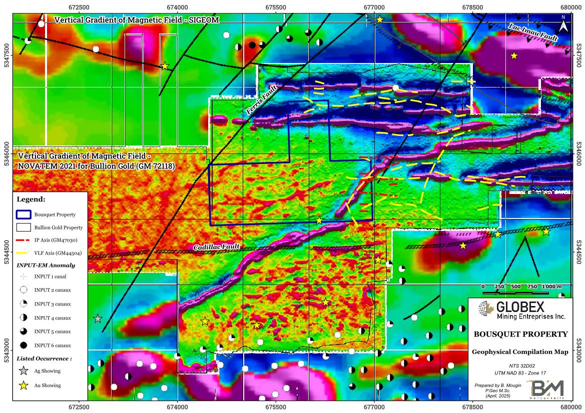
A single showing is listed on the Bousquet property of Globex. The Normar-Nord gold showing is composed of disseminated pyrite in fractured and rusty greywacke. Assays up to 1.72 g/t Au over 1.22m were intersected in DDH (GM35576).
The NE-SW Ferris Fault strikes just west of the Bousquet property and represents a secondary structure connected to the Cadillac Fault which could have served as a drain for late sulphide remobilisations. The Lac Imau Fault strikes in ESE-orientation about 30 km north of the property.
History
Historical Work (1934 – 1989)
Due to its location between the prolific Doyon-Bousquet-LaRonde Mining Camp to the northeast and the Cadillac Fault to the south, numerous historical work have been undertaken in the area of the property by mining companies since the 1930’s. However very few of it was carried out directly on the Bousquet property. Table 2 below gives a brief summary of historical works carried-out before 1989 in the direct vicinity of the Bousquet Property.
Table 2 : Summary of historical work on the Bousquet Property
| Type of work | Document |
| Geological Mapping | GM 12961, GM 20816, GM 49102 |
| Magnetometry (MAG) | GM 19126, GM 33251, GM 33962, GM 43125, GM 43967, GM 44504, GM 49102 |
| Electromagnetism (EM) | GM 19126, GM 33251, GM 33962, GM 35575, GM 43125, GM 43967, GM 44504, GM 49102 |
| Induced Polarization (IP) | GM 34572, GM 47030, GM 47030, |
| Trenching | GM 49102, GM 50439, GM 49102 |
| Soil Geochemistry | GM 34572 |
| Diamond Drilling (DDH) | GM 35576, GM 61411 |
| Property Report | GM 66075, GM 44335, GM 50439 |
Recent work (2003 – Present)
| Year | Type of work | Company | Document | Description |
| 2003 | DDH | Twin Mining Corp. | GM 61411 | 1 DDH (TMN-03-29) on the Bousquet property, no Au anomaly. |
| 2007 | Airborne geophysics | Globex Mining | GM 64063 | 39.5 line-km Mag and EM survey over the property at 100m line spacing. No EM anomalies were identified in this block. |
| 2010 | Line cutting, Ground magnetics | Globex Mining | GM 65376 | 12.3 line-km Mag survey on N-S lines 200m spaced. |
| 2012 | Grid mapping, grab sampling | Globex Mining | GM 67217 | 100m spacing between N-S lines, 9 grab samples, no Au anomaly. |
| 2015 | Ground MAG | Vantex Resources | GM 68965 | 127 N-S lines, 50m spaced. |
| 2021 | Airborne magnetics | Bullion Gold | GM 72118 | 1,114 line-km of survey, englobing the entire Bousquet property |
Historical geophysical work revealed a quite flat magnetic relief which confirmed the general ESE orientation of the regional foliation in the property area and highlighted several E-W to NE-SW VLF axis on the Bousquet property (GM44504), some of which seem to concord with roughly E-W PP axis (GM47030). Such a combination of EM and IP anomalies may suggest the presence of significative sulphide mineralization in the bedrock. No DDH seem to have tested these targets.
Another interesting combination of an IP anomaly concordant with a strongly magnetic iron formation is mentioned by Globex in GM67217.
Bullion Gold Resources Corporation has completed a first drilling program of nine (9) holes totaling 2,381 meters in 2021. These holes drilled to verify the historical data and intersected significant Au mineralization. Hole BO-21-08 intersected a 9-meter gold section grading 16.96 g/t Au including a 4.5-meter zone grading 33.21 g/t Au also including 1 meter at a grade of 129.25 g/t Au while BO-21-09 revealed a gold zone of 4.5 meters at a grade of 3.21 g/t Au including 2 meters at a grade of 4.11 g/t Au.
Resources and Potential
The Bousquet property is ideally located near two geological environments highly favourable for gold mineralization : the Cadillac Fault to the south, and the Doyon-Bousquet-LaRonde mining camp to the northeast.
The very high resolution NOVATEM survey of 2021 highlights that the western part of the Bousquet property presents a magnetic environment similar to the one associated with several Au showings further south. As these showings are associated with DDH assays up to 16.96 g/t Au over 9m (BO-21-08) and 12.10 g/t Au over 7.13m (PA-6), this observation is very interesting.
Exploration work carried-out directly on the Globex’s Bousquet property in the past have mainly consisted in geological mapping and geophysical surveys but these surveys were of limited extension. Moreover, very few outcrops are available for surface observations and limited trenching has ever been undertaken, as well as one (1) single hole at the south edge of the property, so that the real potential of the Bousquet property still remains relatively unknown.
New ground geophysics (EM-VLF, IP) would help in locating secondary structures which could have concentrated sulphide mineralization on the Bousquet property.
Bullion Gold is currently exploring the property but doesn’t seem to have drilled any hole since their 2,381 meters’ program of 2021.

