Cavelier
Location, Access, Description
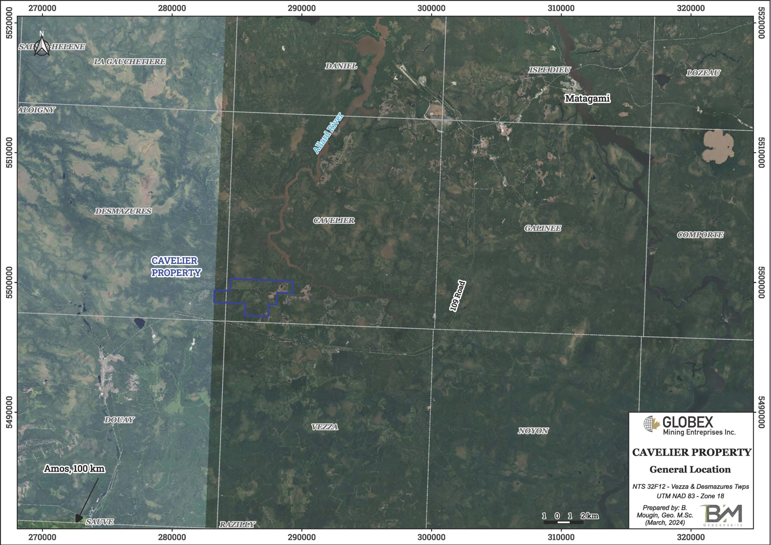
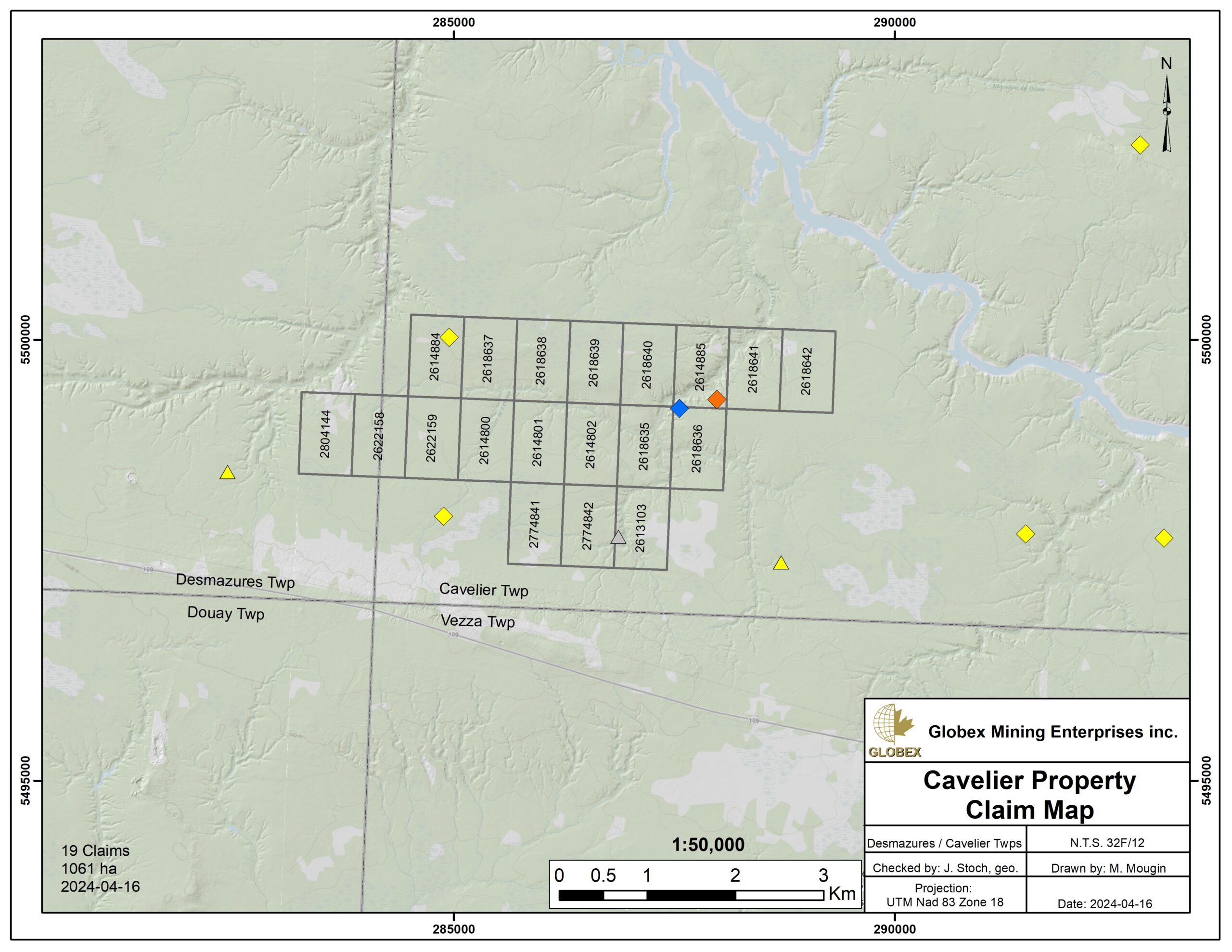
The Cavelier property is composed of 19 contiguous mining claims covering an area of 1,061.1 ha located in Cavelier and Desmazures townships in Abitibi (NTS: 32F12). The property is located about 165 kilometres north of the town of Val-d’Or and 30 kilometres southwest of the town of Matagami. The claims are wholly owned by Globex and are not subject to any underlying royalties or third party interests.
The topography is sparsely marked and consists of rolling hills (Cartwright Hills), with elevations comprised between 260m and 280m above sea level. Several streams, rivers and wetlands can be observed on the property. The northern half of the property seems to be swampier than the southern half.
The property is easily accessible via Highway 109 which connects Amos and Matagami. At about Km 190 coming from Amos, one takes a forest road heading north to access to the property. Numerous exploration trails allow one to easily navigate in vehicle throughout the property.
Geology and Mineralization
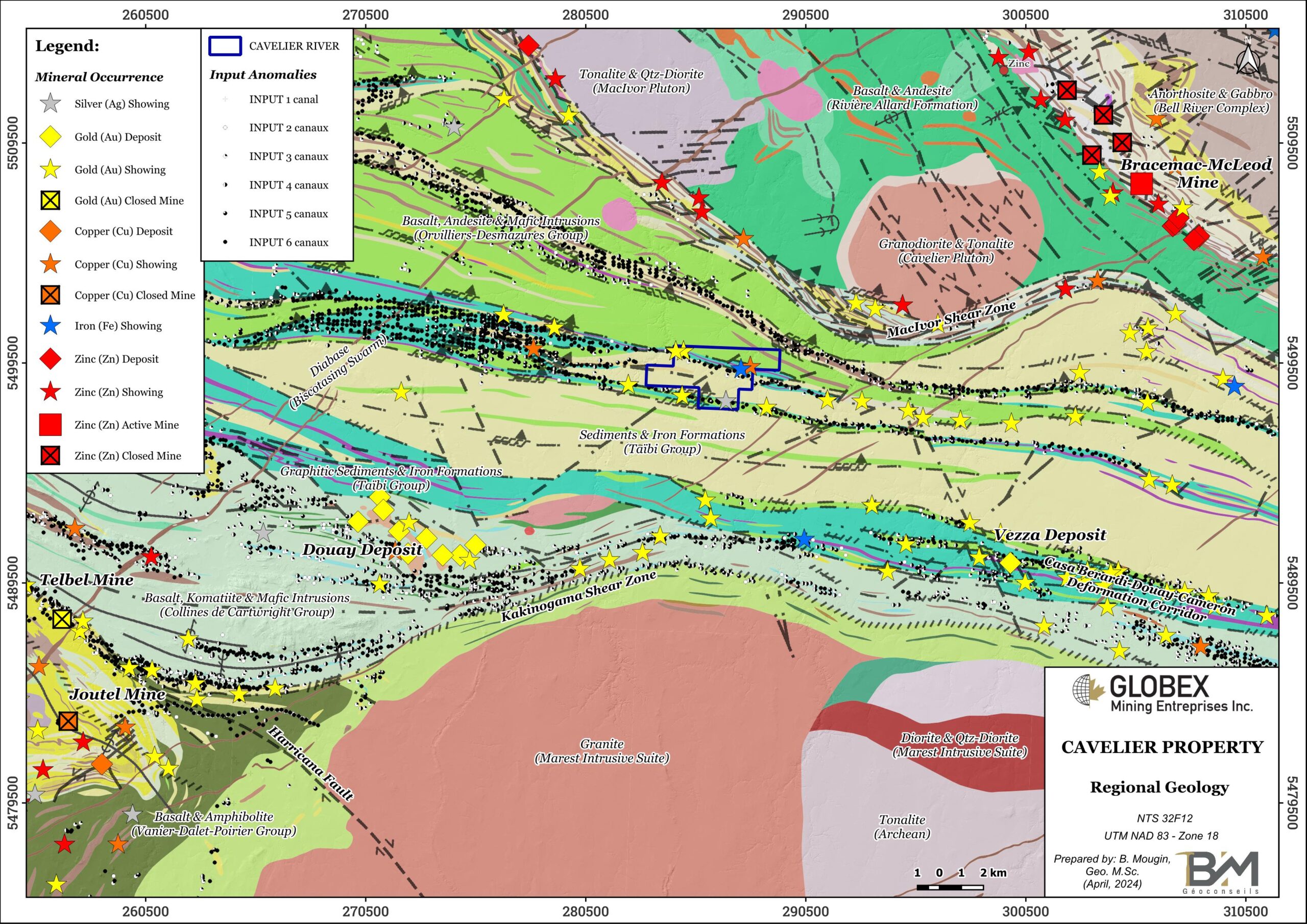
The Cavelier property is located in the Archean Greenstone Belt of the Abitibi Sub-province, in the Superior Province of the Canadian Shield. It’s more precisely located in the central-western part of the Northern Volcanic Zone of Abitibi (ZVN), within the Harricana-Turgeon Furrow (SHT) as defined by Lacroix et al., 1989 (PRO89-04). The SHT is composed of felsic to ultramafic metavolcanics intercalated with metasedimentary rocks of Matagami and Taïbi Groups in the northern contact of the Marest Batholith. They have a sub-vertical dip and peaks facing north according to Dussault, 1990 (MB90-43). The Marest Batholith is a pre- to syntectonic intrusion composed of foliated and locally porphyritic quartz-diorite and granodiorite (PRO89-04). Regional metamorphism is at the greenschists grade.
In the area of the Cavelier property, the SHT consists of two (2) distinct lithotectonic domains corresponding, from north to south, to the detrital sediments of the Taibi Group and the Orvilliers-Desmazures volcanics (northern volcanics of Dussault, 1990). The Taïbi Group is composed of a homoclinal sequence of clastic sediments (sandstone, siltstone, mudstone, grauwacke and argillites) and limited iron formations and conglomerates. Northern Volcanics are located between the Taibi sediments to the south and the Bell River Complex to the north. They are limited to the east by the Olga Pluto (PRO89-04, MB90-43). They are of 2 types : 1) basaltic flows and 2) rhyolitic tuffs.
Intrusive rocks like the MacIvor, Cavelier and Marest Plutos cover more than 40% of the SHT area. They belong to various plutonic sequences that can be assigned to four structural classes: pretectonic, pre- to early syntectonic, syn- to late tectonic and late- to post-tectonic (PRO89-04). The Bell River Complex is a stratified gabbro-anorthosite complex located about 20km NE of the Cavelier property, and associated with numerous base metals (Ni, Cu, Zn, Fe, V) deposits.
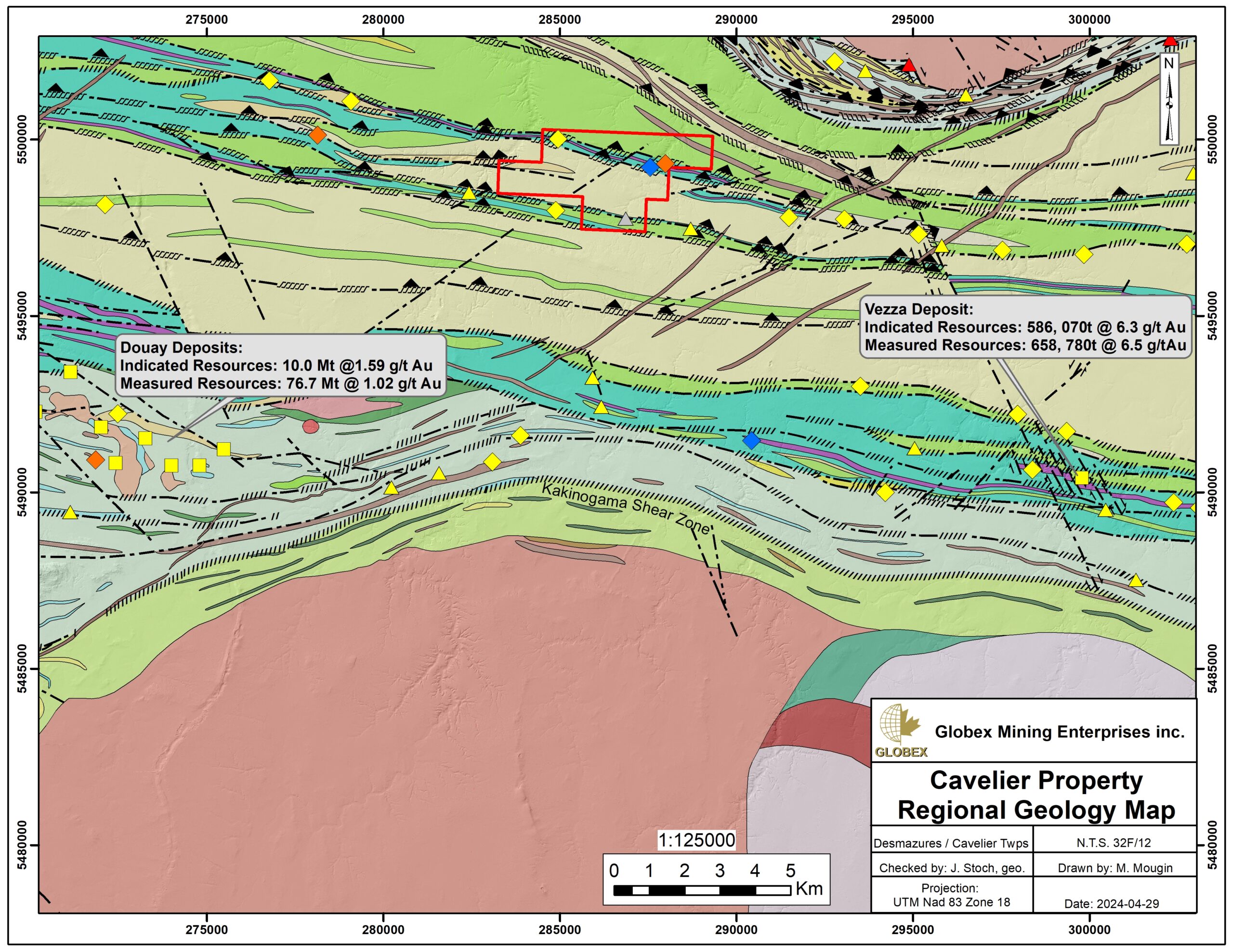
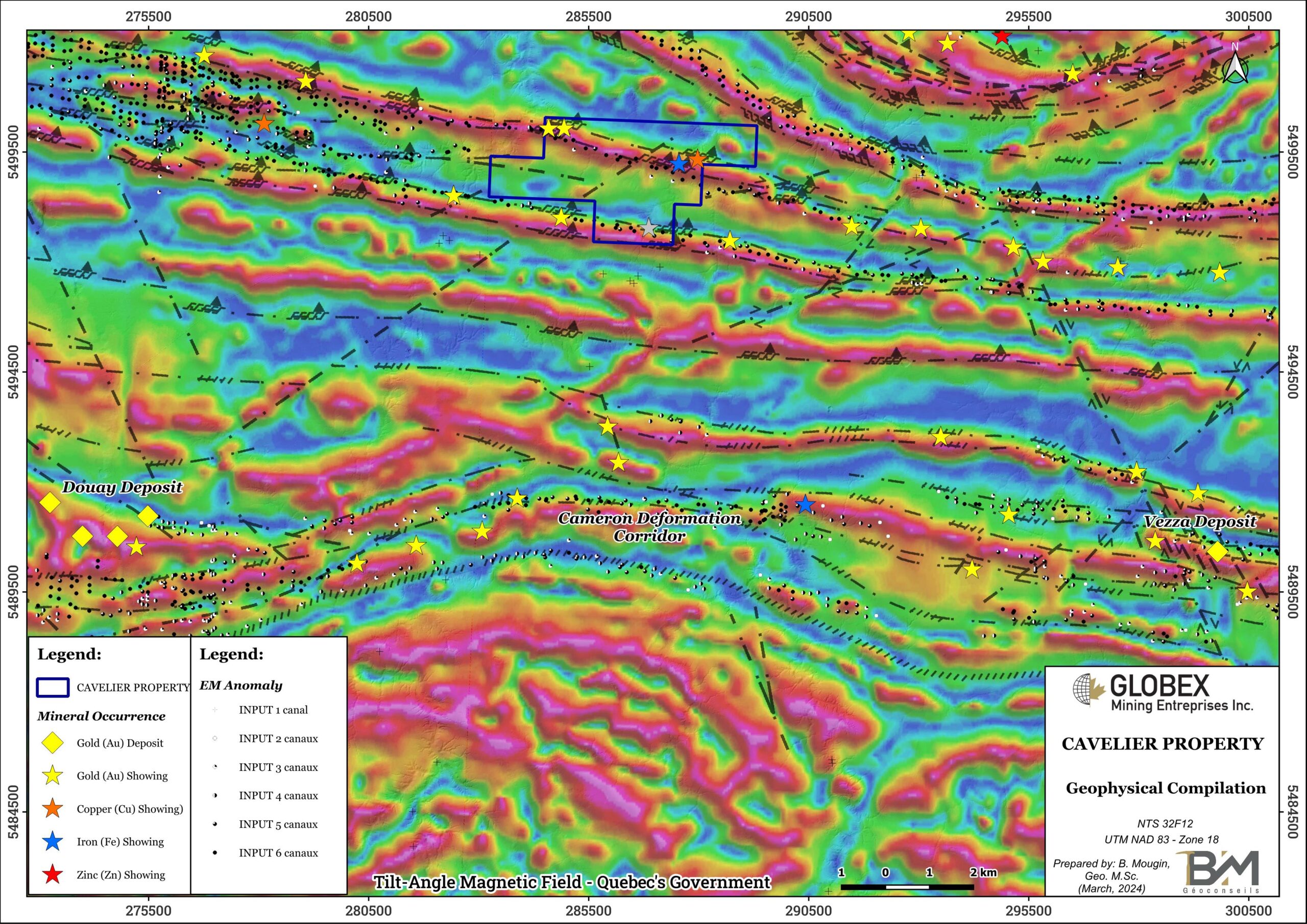
Mineralized deposits of the SHT are either of polymetallic or gold types. Known showings and deposits are primarily found within the Cameron Deformation Corridor (CDC). The CDC is the major regional structural feature which is characterized by a series of anastomosed E-W shear zones that extend on more than 150 kilometres east and west of the Rivière Allard property. The CDC is 1-5 km wide and roughly corresponds to a graphitic band within Taïbi sediments, right north of the Cartwright Hills volcanics. The CDC hosts both Douay (Indicated Resources of 10.0 Mt @ 1.59 g/t Au – Gosselin et al., 2022 – Technical Report NI 43-101) and Vezza (Indicated Resources of 586 070t @ 6.3 g/t Au; Measured Resources of 658 780t @ 6.5 g/t Au – D’Amours et al., 2013 – Technical Report NI 43-101) deposits and therefore represents the best regional metallotect for gold and base metals mineralization.
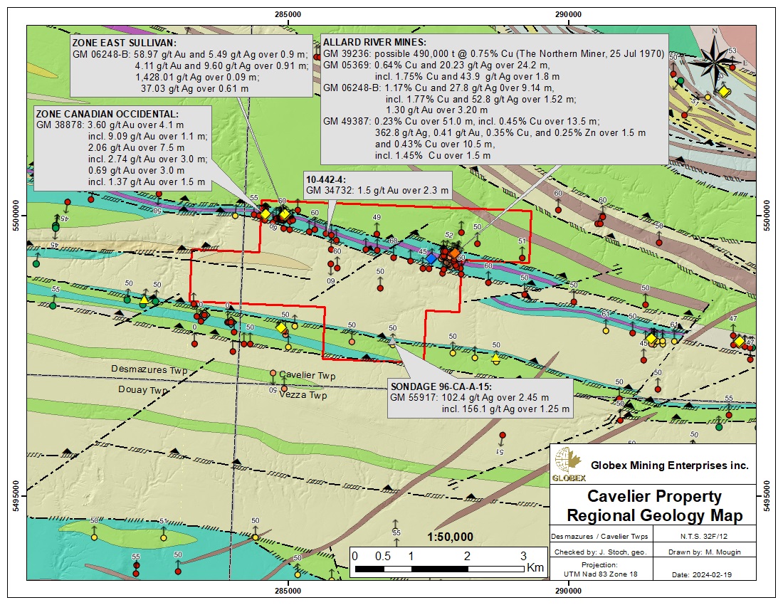
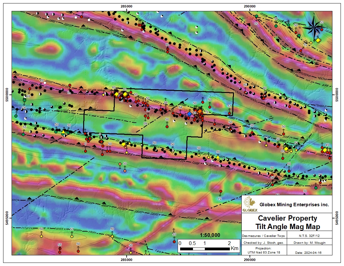
Two deformation corridors parallel to the CDC are known on the Cavelier property and are associated with numerous Input anomalies as well as both gold and base metals showings. Thus, the Cavelier property hosts the “Zone East Sullivan” (up to 4.11 g/t Au and 9.60 g/t Ag over 0.91m – DDH CP-50) and “Zone Canadian Occidental” (3.60 g/t Au over 4.1m – DDH CAV-07-81) showings, the “Allard River Mines” (up to 1.17% Cu et 27.8 g/t Ag sur 9.14m – DDH CP-1) showing, the “Provinces X” (up to 50% Mt in iron formations) showing and the “96-CA-A-15” (156.1 g/t Ag over 1.25m – DDH 96-CA-A-15) showing.
History
Because of its difficult access and the scarcity of its outcrops, the Matagami-Joutel region was mainly explored by indirect methods. Thus numerous Mag-EM surveys have been carried-out between the late 50’s to the late 80’s by various exploration companies (Rivermede Exploration, SOQUEM, Teck Corp., Canamax…). Several anomalies were highlighted and explained by both graphitic horizons, iron formations and sulphide mineralizations in DDH core.
Several diamond drilling programs were also carried-out to test the best anomalies and led to the discoveries of several gold and base metals on and in the vicinity of the Cavelier property (GM05369, GM06248-B, GM40371, GM38878, GM45494, GM49387). Of particular interest we can cite the 66 DDH campaign by East Sullivan Mines in 1958 (GM06248-B) which led to the discoveries of the “Zone East Sullivan” gold showing, the “Allard River Mines” and “Douay-Desmazures-Ouest” copper showings and the “Provinces X” iron showing. The 13 DDH campaign by Jack Stoch Geoconseils and Canadian Occidental Petroleum in 1982 (GM38878) led to the discovery of the “Zone Canadian Occidental” gold showing.
In 1989 Vior and Jack Stoch Geoconseils carried-out compilation of historical geoscientific data as well as new IP and 2,806 m of DDH (13 holes). No significant mineralization was observed in core samples and Pulse-EM was undertaken in 2 holes, without success either (GM49387).
Between 1990 and 1992, Serem Quebec carried-out line-cutting, Mag, EM and IP surveys, as well as 539.2 m (19 holes) of reverse drilling and 1,335.2 m (5 holes) of DDH (GM50528, GM50720, GM50520, GM50723, GM51253, GM51591). These works highlighted a few geophysical anomalies and DDH led to the discovery of both “Serem: Zone Ouest” and “Serem: Zone Est” gold showings.
Between 1994 and 1996, GeoNova Explorations optioned the Cavelier property from Serem Quebec and undertook line cutting, mag and IP surveys, humus sampling and 3,037.9 m (16 holes) of DDH (GM52880, GM55917). Best DDH assays returned up to 10.95 g/t Au over 4.00m (“Serem: Zone Est” showing) about 3.5 km east of Globex’s property. The mineralized zones intersected by drilling are all located in cherts and hypersilicified rocks in contact with graphitic faults.
In 2000, Jack Stoch Geoconseils and Aurogin Resource carried-out 42.4 km of AEROTEM survey over the Cavelier property which outlined a few significant bedrock conductors (GM58644). The conductors in question do not appear to have been drilled.
In 2001, the Quebec MERN carried-out new sediment sampling in 35 stratigraphy holes from Joutel area dating from 1986, in order to identify kimberlite indicator minerals (KIMs) (GM58800).
In 2018, Maple Gold carried-out regional-scale exploration program in the Cavelier property area in order to identify exploration targets similar to the Douay deposit. This program included geological mapping and sampling, LiDAR, Spectral imagery and teledetection and succeeded in discovering a few new mineralized zones (GM71020).
In January 2022, Geotech undertook Mag-VTEM airborne survey on the Montgolfier property of Eldorado Gold located directly to the north of the Cavelier property of Globex (GM73168).
Resources and Potential
The Cavelier property benefits of a privileged location a few kilometers north of the prolific Cameron Deformation Corridor (CDC) that host most of the regional gold (Au) deposits and some base metals showings. A thick overburden covers the rocks of that area, meaning that most of exploration work has to be done using indirect methods and that the geology of this area is still poorly understood so that numerous discoveries can still be made.
The existence of numerous EM anomalies along the Cameron Deformation Corridor (CDC) is explained in historical works by either graphitic horizons and strong sulphide contents. It’s therefore recommended to proceed to a complete compilation of historical geoscientific data of the Cavelier property in order to verify if 1) known showings and anomalies have been properly followed in strike and at depth in DDH and if 2) all historical EM / IP anomalies have been explained by stripping or drilling. Eventually new ground EM / IP surveys will be necessary in order to cover the entire property.
The presence of secondary faults generally oriented NE-SW and NW-SE can be deduced with magnetic and electromagnetic surveys in this area (MB90-43). As orogenic gold is frequently concentrated into secondary structures secant to the regional main structures (Vezza and Douay deposits), a Very-high Resolution Mag Survey should be carried-out in order to identify if unknown secondary structures are present on the Cavelier property. Best exploration targets on the Cavelier property would be marked by IP / EM anomalies along secondary structures secant to the CDC.
Channel sampling should be considered on the best coincident anomalies in order to observe alterations, mineralization and structural directions before panning DDH.

