
Duval Ouest
Location, Access, Description
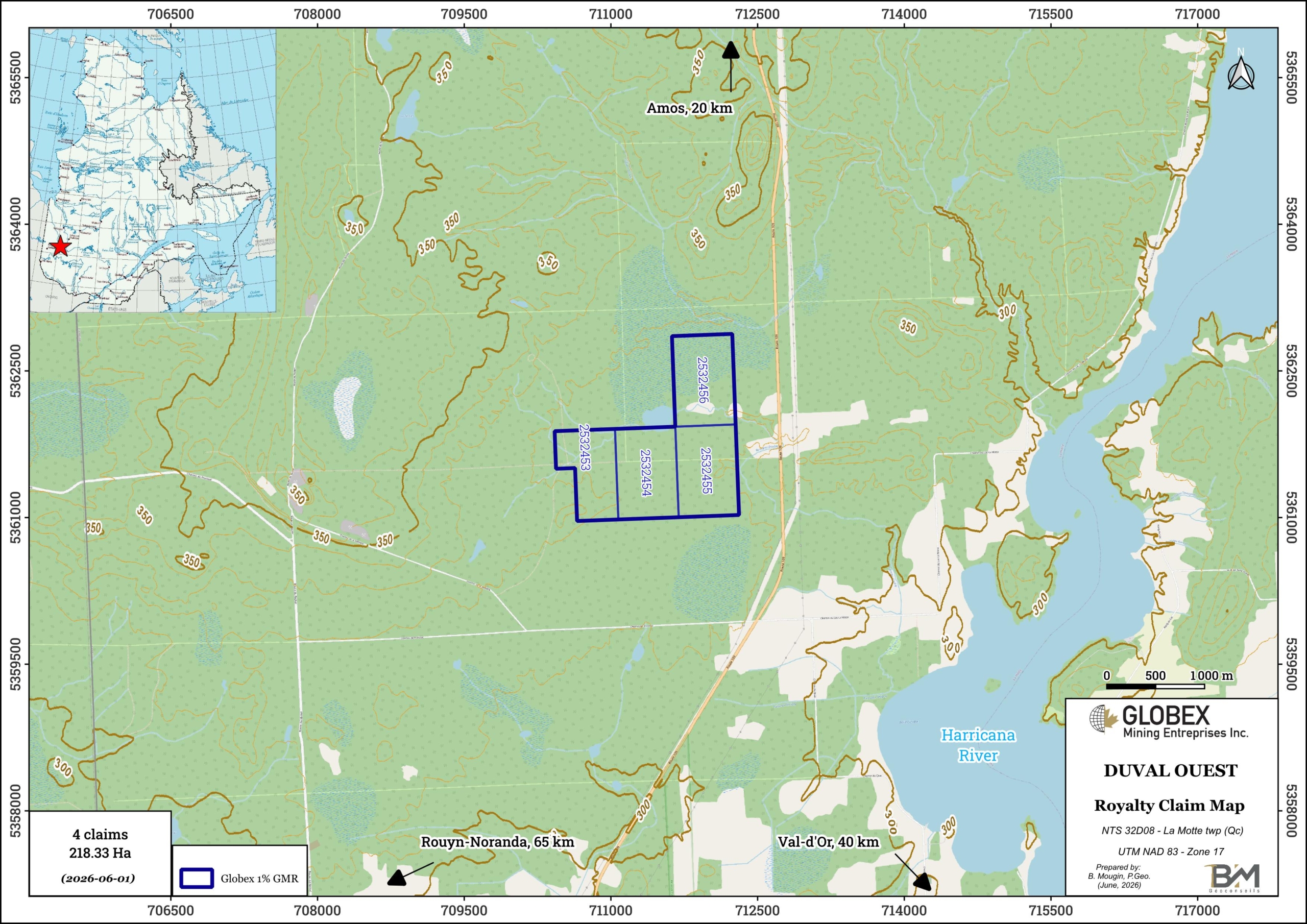
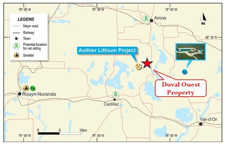
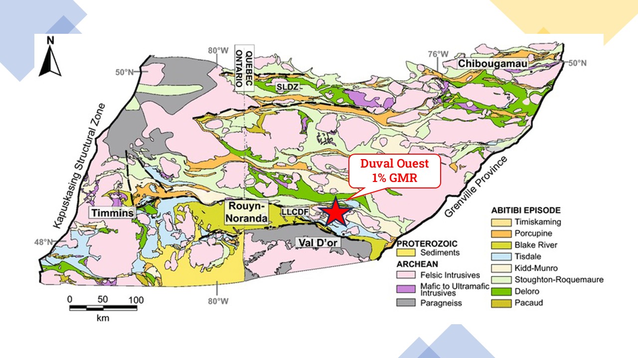
The Duval Ouest property consists of 4 mining claims covering an area of 218.33 Ha in La Motte township, northwestern Quebec, approximately 20 km south of Amos (Qc) and 45 km northwest of Val-d’Or (Qc).
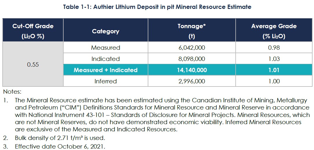
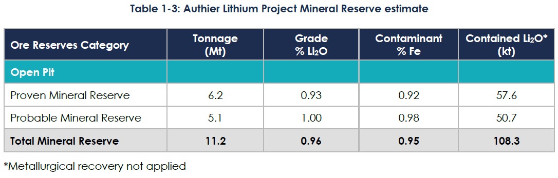
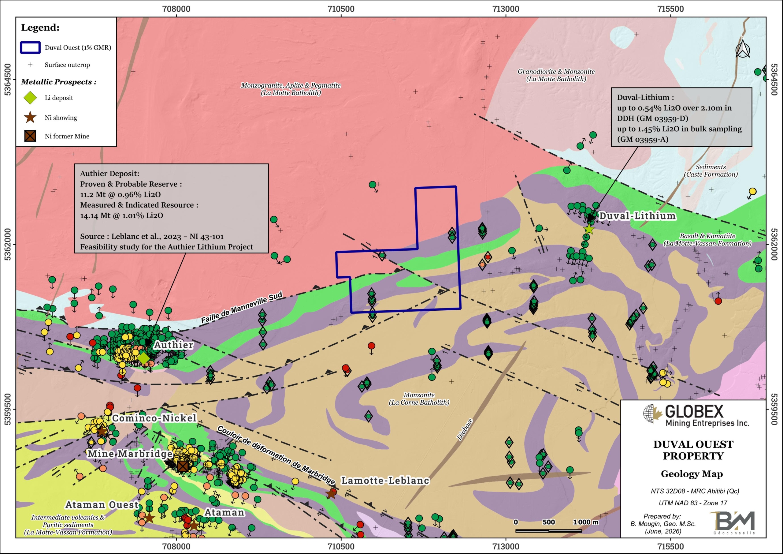
The claims belong to Linear Minerals Corp. and are located east of the Authier Lithium Project of Sayona Quebec Inc, in the same lithotectonic assemblage. The Authier deposit hosts Proven and Probable Reserve of 11.2 Mt @ 0.96% Li2O, and Measured and Indicated Resource of 14.14 Mt @ 1.01% Li2O (Leblanc et al., 2023 – NI 43-101 Feasibility study for the Authier Lithium Project). Globex will retain a 1% Gross Metal Royalty (GMR) on any future production on these specific 4 claims. Globex also hosts 0.5% to 1.5% GMR on several other assets in the area.
The property is centred in a well- developed mining region with many resource industry support facilities and services. The towns of Rouyn-Noranda, Val-d’Or and Amos have populations of between 25,000 and 60,000 and are well known for their mining history. The project is readily accessible by national highway and a high-quality rural road network.
Geology and Mineralization
The Duval Ouest property is located within the Abitibi Subprovince of the Canadian Shield. The Abitibi Subprovince is an Archean greenstone belt which hosts some of the richest mineral deposits of the Superior Province; it is divided into two distinct parts (Chown et al., 1992): the South Volcanic Zone (SVZ) and the North Volcanic Zone (NVZ), separated by the Destor-Porcupine-Manneville fault.
The property lies at the stratigraphic base of the Malartic Group (Dimroth et al., 1982) which extends from just north of the town of Val D’Or up to the Destor-Porcupine Tectonic Zone. The Malartic Group consists of a volcano-sedimentary assemblage characterised by the predominance of komatiitic and tholeiitic lava flows. It is divided in three formations which are from bottom to top: (1) the Lamotte-Vassan Formation, (2) the Dubuisson Formation, and (3) the Jacola Formation. This volcano-sedimentary assemblage is crosscut by pre to post-tectonic plutons and by NE-SW Proterozoic dykes.
Rocks of the area are squeezed between the Preissac, La Corne and La Motte batholiths which together constitute the Preissac-La Corne Plutonic Suite. Rocks were strongly deformed and present evidences of a moderately east-dipping stretching lineation. The regional Manneville-Sud Fault runs through the Duval Ouest property in ENE orientation. The Marbridge shear zone is also associated with several Ni (±Cu ±EGP) prospects, including the Marbridge former mine (historical production of 703,027 tonnes grading 2.28% Ni for a total of 12,000 tonnes Ni and 543 tonnes Cu). The La Motte Anticline (Imreh, 1984) is an overturned fold inclined to the south. Regional metamorphism generally exhibits a green schist facies and can reach an amphibolite facies near large intrusions.
South of the Manneville-Sud Fault, the Duval Ouest property is underlain by intermediate intrusive rocks of the Preissac batholith and volcanics of the Lamotte-Vassan Formation (LVF). The LVF consists largely of komatiites with lesser intercalated basalts and minor felsic volcanoclastites and undifferentiated metasediments. This largely ultramafic sequence is intruded by three major batholiths (ET84-03; RG160; MM82-04) : the La Motte, Preissac and Lacorne Batholiths, respectively of monzogranitic, granitic and granodioritic compositions.
North of the Manneville-Sud Fault, the property is mainly composed of granite and pegmatite of the La Motte Batholith which formed during the Archean (2.641 to 2.647 Ma) in the sedimentary rocks of the Kewagama Group ; the La Motte Batholith occupies the NE part of the Preissac-La Corne Plutonic Suite which is considered the source of lithium- and rare metals-bearing pegmatites.
The most valuable commodity present in the area is lithium, hosted within spodumene-bearing pegmatite intrusions. The Duval-Lithium showing is located 2 km east of the property and corresponds to two spodumene-bearing pegmatite dykes oriented N290°/-45° and N285°/-45° to -85° (RG 160).
The reference deposit of the area is the Authier deposit which is located about 3 km west of the property and hosts two separate mineralised pegmatite systems, including:
- Authier Main – 1,100 metres long striking east-west, with an average thickness of 25 metres (ranging from 4 metres to 55 metres), dipping 40 to 50 degrees to the north. The deposit outcrops in the eastern sector and then extends up to 10 metres under cover in the western sector. The deposit remains open in all directions; and
- Authier North – 500 metres long striking east-west, with an average thickness of 7 metres (ranging from 6 metres to 8 metres), dipping at 15 degrees to the north. The Authier North pegmatite appears at shallow levels (15 to 25 metres vertical depth). The deposit remains open in all directions.
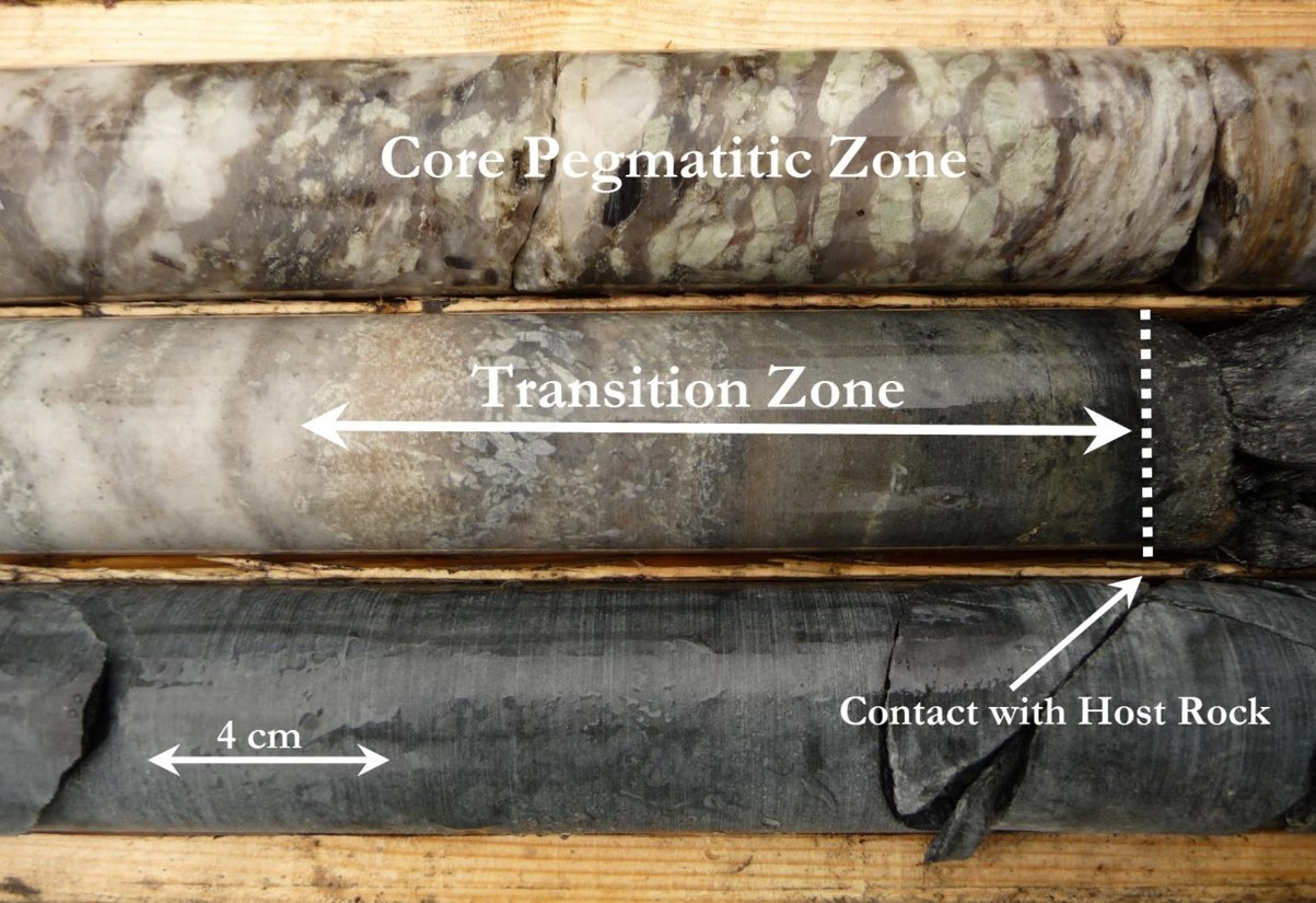
The lithium mineralisation at the Authier project is related to multiple pulses of spodumene bearing quartz-feldspar pegmatite. Higher lithium grades are related with high concentrations of mid-to-coarse spodumene crystals (up to 4 cm long) in a mid-to-coarse grained pegmatite facies :
JORC Mineral Resource
In 2023, Sayona Mining Ltd. (now Sayona Quebec Ltd.) released a positive NI 43-101 Feasibility Study for the Authier Lithium Project (Leblanc et al., 2023). Estimation of Mineral Resource and Reserve are presented in tables below :
History
Exploration for pegmatites in the Preissac-La Motte area began in the early 1900s; the presence of molybdenite was first reported in 1901 (RG 160). The primary focus was initially on molybdenum. In 1942, the discovery of spodumene pegmatite at the site that would become the Québec Lithium Mine sparked interest in lithium. Exploration for lithium increased with the development of the Québec Lithium Mine in the 1950s and declined with the mine’s closure in 1965, partly due to falling prices and a declining market for the metal (GM 65011). In 1957, the discovery of the nickel deposit at the Marbridge Mine, which was mined from 1962 to 1967, sparked a boom in nickel (RG 160). In the early 2000s, interest in lithium increased.
Little work has been done on the property. An electromagnetic survey conducted in 1965 identified conductive zones within the property area. In 1973 and 1974, small surface drill holes were drilled to depths of less than 76 m to test electromagnetic anomalies. The aim was to find copper and nickel mineralization in ultramafic rocks.
Recent work and developments :
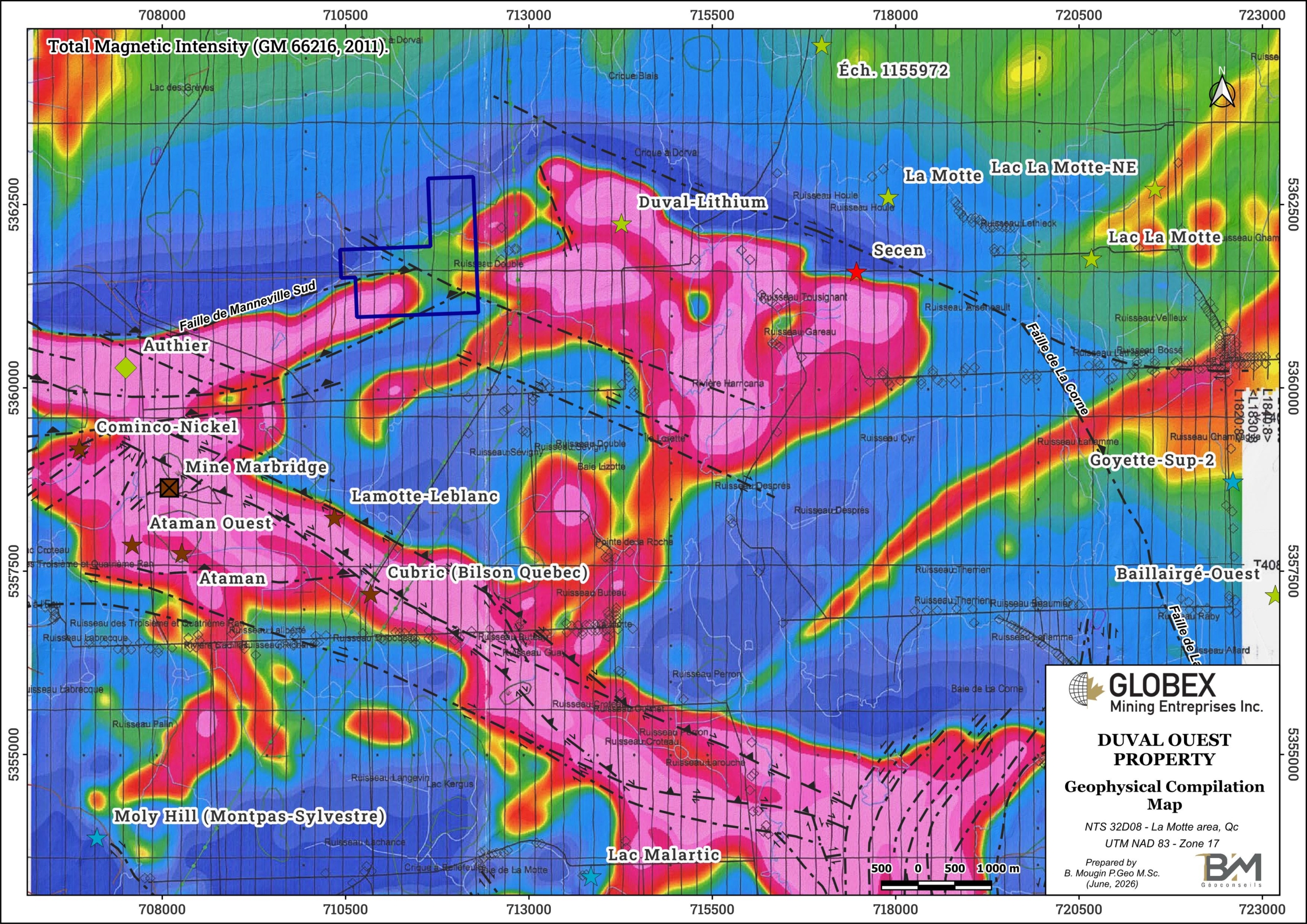
In 2007 and 2011, helicopter-borne magnetic and electromagnetic surveys were also conducted on the property (GM 66216). Magnetic data shows a continuity of geological units between the Authier deposit and the Duval Ouest property.
In 2020, Globex conducted a historical work compilation report on the Duval Ouest property (GM 71710). This represents the most recent work listed in public data for the Duval Ouest property.
Resources and Potential
Limited historical work has been undertaken directly on the Duval Ouest property in the past; no recent magnetometry is available on the property, and only 6 shallow overburden holes have been implanted on the property for a total length of 57 meters.
The geological location of the property and close proximity to lithium and rare metal showings and deposits suggest a favorable potential for the discovery of mineralized pegmatite. Therefore spodumene pegmatites are still likely to be discovered on the Duval Ouest property.
Future exploration work should include high resolution airborne magnetic and gravimetry surveys, as well as scintillometer prospection and grab sampling in order to identify mineralized pegmatites below overburden.