
Gem Hill
Location, Access, Description
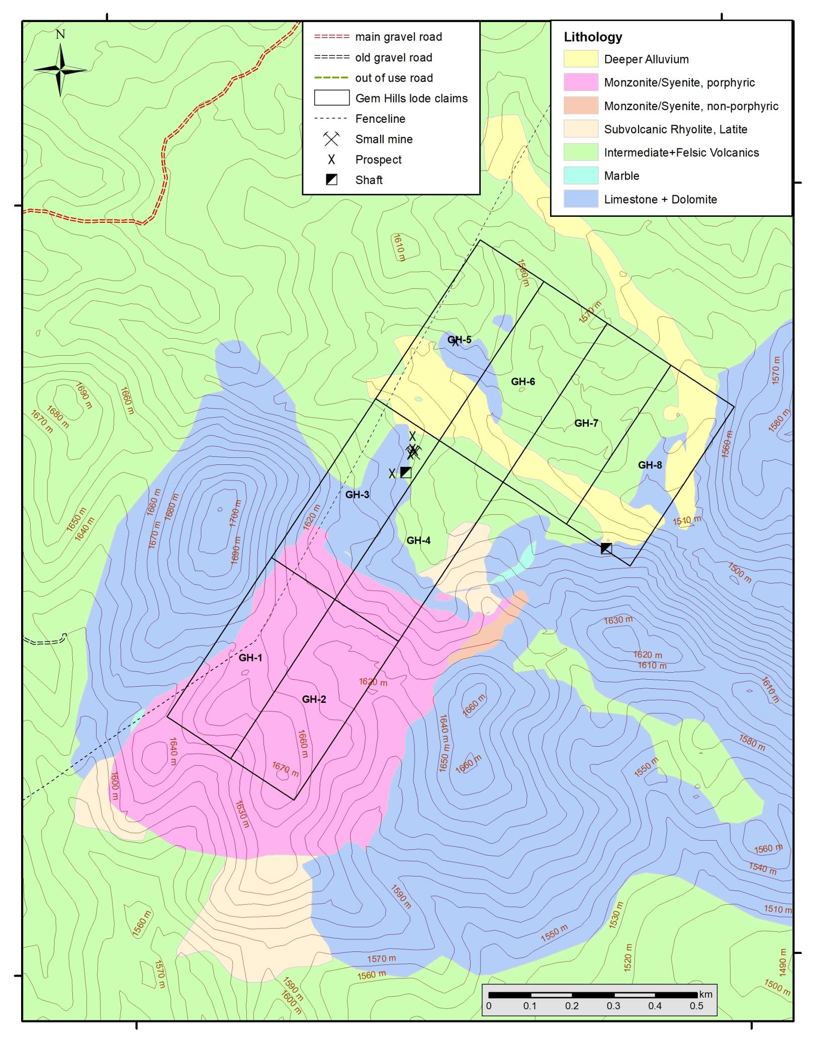
The property was staked to cover rare earth elements (REE) mineralization that had been discovered in 2024 by Globex during a regional prospecting campaign. The project is located outside any known mining district. Globex staked a contiguous claim block consisting of 8 unpatented lode claims in October 2025. Each claim is 457 m (1500 feet) long and 183 m (600 feet) wide (20.66 acres or 8.36 ha), totaling a surface area of 66.89 ha. The entire Globex claim block lies on public land and is outside of any conservation area (e.g. areas of Critical Environmental Concern or Wilderness Areas).
The Gem Hill project is situated at the eastern slope of the Clover Mountain Range at elevation ranging between 1500 and 1700 m. Highest peaks of the Clover Mountains reach altitudes of 2000 to 2325 m. Some areas are covered by dense, partly thorny shrubs and bushes, other areas are dominated by pine and juniper trees. Climate is mostly dry with a rather small average amount of rainfall during the year and occasional heavy precipitation (mostly rain, but some snowfall common, during the winter time). Temperatures range from moderately warm during the summer to cool with short freezing periods in winter time.
There is no access road into the property, but there is a gravel road passing 1 km to the NW of the property. From Las Vegas this point can be accessed via motorway I-15N and gravel roads. Total driving distance from Las Vegas is about 175 km; driving time (best with 4×4 vehicle) is about 3 to 3.5 hours.
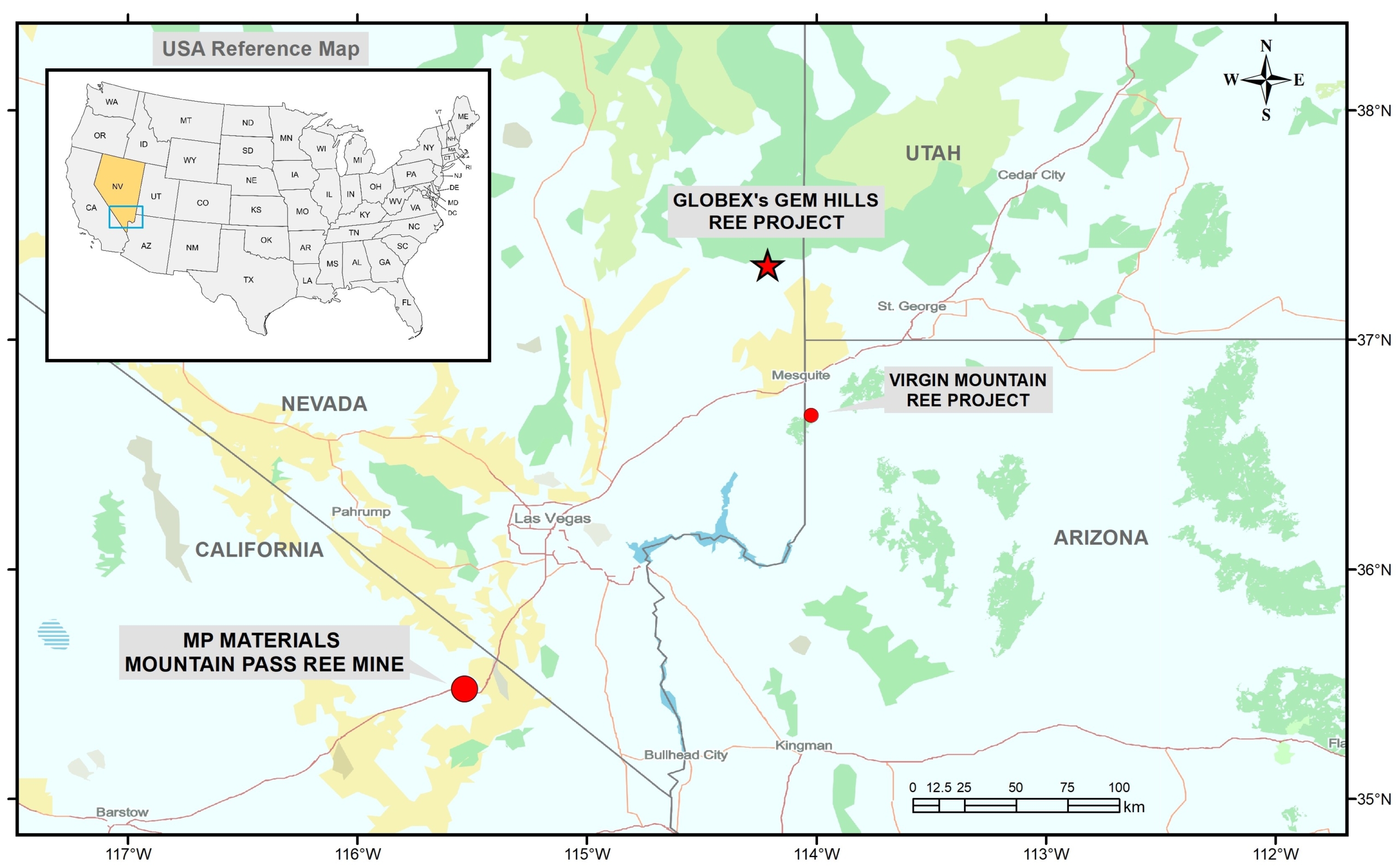
Above map shows the location of the Gem Hills property and the location of MP Materials Mountain Pass REE mine and the Virgin Mountain REE project (optioned from Globex to Lodestar Minerals Ltd.). Mountain Pass accounted for approximately 12% to 14% of the world’s rare earth mined output (mainly LREE). The U.S. government, primarily through the Department of Defense (DoD), provides significant support to MP Materials’ Mountain Pass rare earth mine, including a major 2025 loan for heavy rare earth separation, grants for processing upgrades, and a price-floor agreement for Nd/Pr, all aimed at securing a domestic supply chain for defense and high-tech industries, reducing REE reliance on China, and boosting U.S. industrial independence.
Geology and Mineralization
The Gem Hill property lies at the southeastern margin of the Caliente Caldera Complex, situated in the extreme southeast of the Great Basin geological province. Felsic and intermediate calc-alkaline volcanic rocks erupted between 24 and 18 Ma from the caldera complex during the Late Oligocene until Early Miocene. In the district around the Gem Hills project appear numerous isolated (some several km across) geological windows of Lower Paleozoic carbonate-rocks surrounded by mostly extrusive volcanic rocks erupted from the Caliente Caldera. Isolated small intrusive stocks or plutons of mostly Tertiary age appear locally at the margin of the Caliente Caldera Complex.
Oldest rocks in the property area are generally thick bedded massive limestone and dolomite, probably of Devonian age. These rocks appear in an isolated irregular-shaped domain of carbonate rock measuring about 2.5 km E-W and 2 km N-S. It is surrounded by mid Tertiary volcanic rocks erupted from the Caliente Caldera. Those comprise lava flows, breccias, tuff and subvolcanic stocks/dikes of andesite & dacite, latite, quartz-latite and rhyolite.
Part of the southern portion of the property is dominated by an almost rectangular-shaped SW-NE orientated intrusive stock of subvolcanic mostly porphyritic alkaline monzonite and syenite with dimensions of about 500 x 800 m.
In 2024 Globex had collected 13 surface rock samples within and in the vicinity of the Gem Hills property. In late 2025 a total of 39 rock samples (34 within the property), including 17 channel samples, had been collected from seven hand dug trenches, from mine dumps and from rock outcrops.
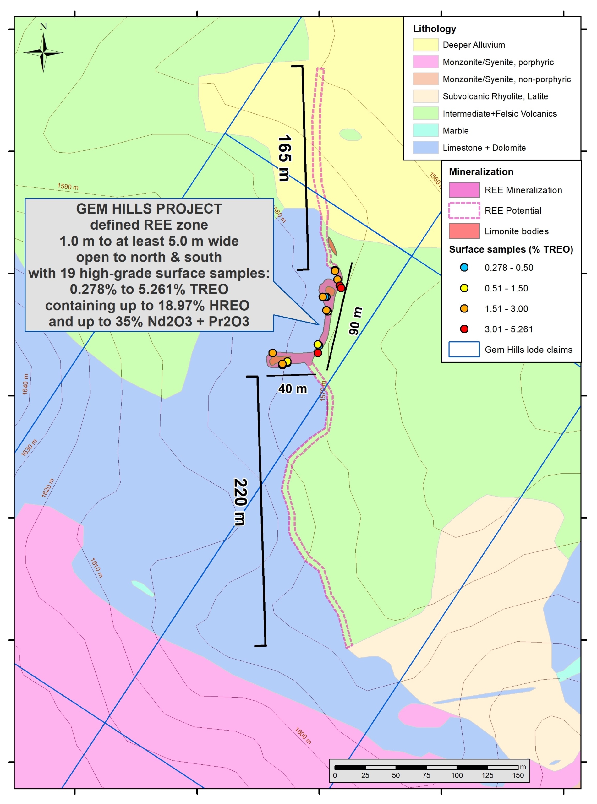
REE mineralization occurs along the east side of a north trending limestone/dolomite “nose” in faulted contact to felsic volcanic rocks (mainly latite). The contact dips steeply W and E and is not linear, but undulated with several indentations. Larger mineralized zones developed in these indentations or deeper embayments. Locally near the contact appear also massive limonite bodies, limonite replaces here latite breccias. These limonite pockets are short, but can approach width of up to 3-5 m. However limonite bodies do not carry any rare earth mineralization. The REE mineralization developed directly at the brecciated/faulted contact to the Devonian limestone/dolomite, extending further away as mixed clayey breccia zone of carbonate rock and volcanic rock with lower grades, locally extending also into argillic-phylllic altered volcanic rocks. Apparently especially the carbonate fragments had been replaced by REE minerals and mostly, but not always, also by more or less abundant black manganese oxide minerals. Highest grades with highest HREE (heavy rare earth elements) contents came from a mine dump derived from an about 8-10 m deep shaft and from a smaller mine dump. Total mineralization width could not always be exposed by the trenching due to deeper overburden, but varies between about 1.0 m and up to at least 5.0 m. Sampling & trenching indicated that mineralization extends at least along a 90 m long NE-orientated segment, whereas mineralization in indented zones may extend to the west into the limestone domain for up to 40 m away from this NE trending contact line limestone/dolomite to volcanic rocks. REE mineralization is open to the south and north, but is concealed under deeper overburden.
The Gem Hill REE project is characterized by high TREO (total rare earth oxides) and local enrichment of the (more valuable) heavy rare earth elements (HREE).
Gem Hills mineralization contains considerable amounts of the high-value REE from the light rare earth group (LREE) praseodymium, neodymium and from the HREE group gadolinium, terbium, dysprosium, holmium and erbium.
Furthermore mineralization contains abundant yttrium with up to 0.435% Y2O3 (low value in China, but at times very high prices in Europe, USA and Canada due to sanctions and restrictions).
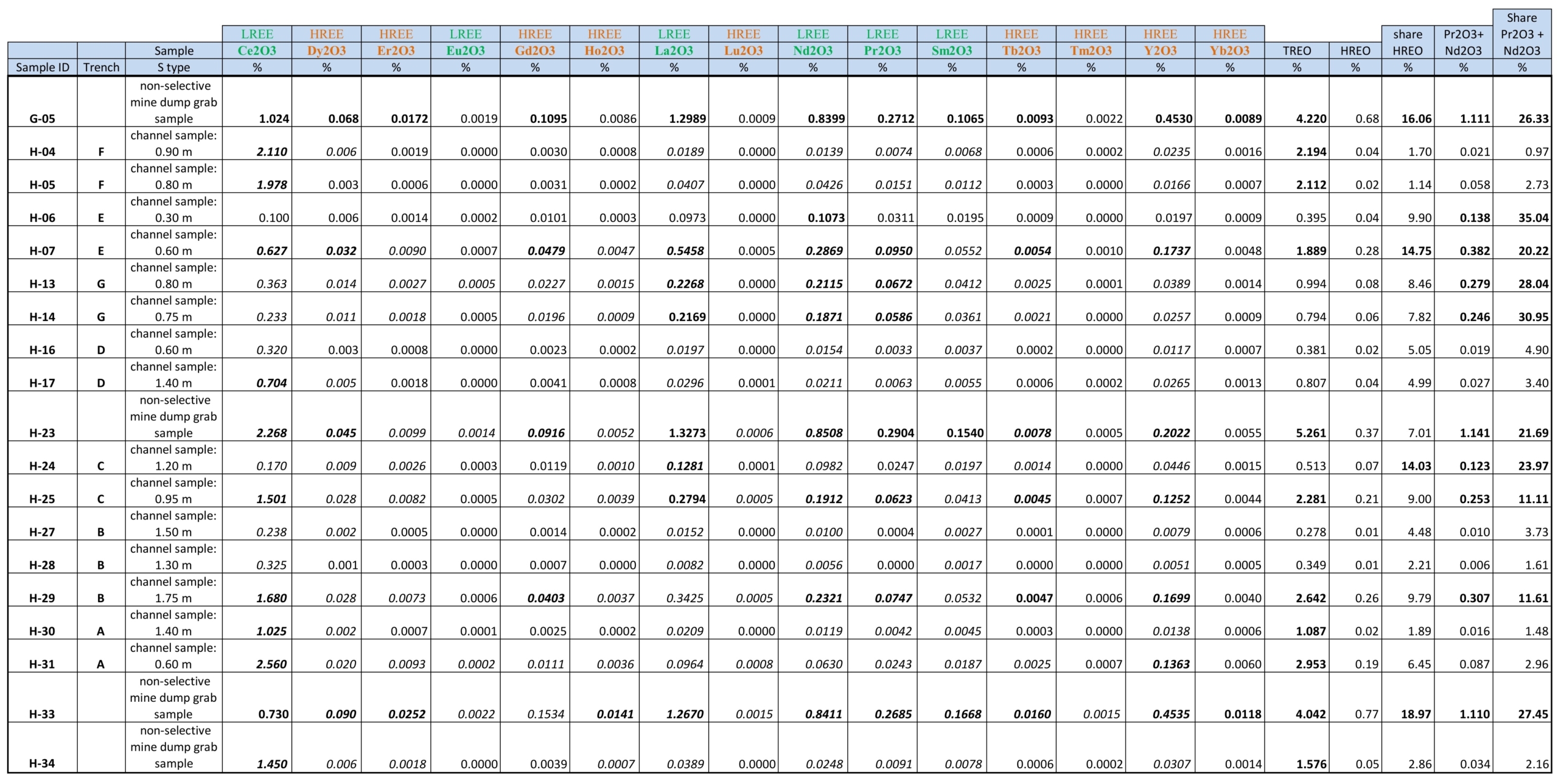
From 34 rock samples collected within the property in autumn 2025, 18 samples returned significantly high rare earth oxide (REO) values (plus one sample collected in 2024) assaying between 0.28% and 5.26% TREO and averaging about 1.7% TREO.
The share of HREO from TREO varies greatly between about 2% and up to 19%, averaging about 8%. Highest HREO share was found in mine dump samples.
The share of high-value REO (these include highly priced HREO and LREO) varies greatly between 1.5% and 39.7%, averaging about 17%.
The share of the LREO Nd2O3 + Pr2O3 from TREO varies greatly between 1.0 and up to 35% averaging 13.7% and approaching a maximum combined grade of 1.14% (11.4 kg/t Nd2O3 + Pr2O3).
Locally some of the most expensive HREE are strongly enriched, those include Dysprosium and Terbium. Highest Dy2O3 grade was 0.09% (0.9 kg/t) and highest Tb2O3 grade was 0.016% (0.16 kg/t).
Major mineral phases had been identified by X-ray diffraction (XRD) testing of four high-grade samples through SGS TEC Services, Lawrenceville, Georgia. The principal mineral assemblage of high-grade ore is dolomite/calcite-nacrite-gibbsite-Mn-oxides-fluorite-monazite. The REE-rich mineral paragenesis at the faulted/brecciated contact between Tertiary felsic volcanics and Paleozoic sedimentary carbonate rocks formed by hydrothermal-metasomatic carbonate replacement, probably through a complex multi-stage magmatic-hydrothermal evolution with a transition from high-temperature, near-neutral fluid transport to a low-temperature, acidic, and highly oxidative environment. Less than 10% of REE are contained in monazite, the bulk of REE might be contained in fluorite, in yet unidentified minor mineral phases (below the 2-3% detection limit of the XRD testing) or is adsorbed to nacrite and gibbsite.
Gem Hills REE mineralization with its unusual mineral assemblage stands alone and appears to represent a new hydrothermal-metasomatic REE deposit type.
Selected Sample List with REO Assay Results from Gem Hills REE property:
History
Historic prospects, shafts and small mines date probably back to the 1930s to early 1940s, as indicated from surface finds. These old workings explored and mined at small scale massive limonite (with low or high manganese contents) and manganese oxides. There existed a narrow access gravel road to the principal workings: an about 10 m deep shaft with mine dump and several small open pits (northern part of lode claim GH-3). Only remnant of this old access road, coming from the SE, are still recognizable in the field. No further historical data could be found in the literature.
No modern exploration programs had been conducted in this area. However, in 1969 the presence of wollastonite was recognized and therefore the area had been staked by several groups, but these lode claims had been abandoned many years ago. Latest active lode claims in the area had been staked in 2002 and abandoned in 2007.
Only regional aeromagnetic and radiometric data with line spacing of 4.8 km are available from a survey flown between 1977 and 1979 for the Caliente map sheet. However there exist reports for a more detailed regional aeromagnetic survey on north-south lines at a line spacing of 1 mile (1.61 km) and an altitude of 9000 feet (2.74 km) flown in 1973. In all available regional magnetic maps a strong geomagnetic high anomaly is centered on the area around the Gem Hill property, it can be related to the monzonite-syenite intrusion (with abundant magnetite) that is situated in the southern part of the project area.
Resources and Potential
With the current level of early-stage exploration data no resource estimation or size potential can be given. For this purpose considerable follow-up exploration steps are required:
One important step should consist in the construction of an access gravel road to the main REE mineralization area. Best suited is probably the rehabilitation of the historic access road coming from the southeast.
Additional trenches should be excavated and channel-sampled in the already known 90 m x 40 m mineralized area. Those should go to depth of about 1.5 to 2.0 m. Trenching should follow-up the possible southern and northern continuation of REE mineralization (along the carbonate rock contact), concealed under shallow and deep overburden (in the north).
It is also recommended to carry out a high-resolution air-born magnetic survey over the entire property area and vicinity (drones could be used). Magnetic patterns might be characteristic for the REE mineralization and could point toward additional exploration target zones.
The planning of an initial diamond drill program (1000 to 2000 m total core length) with inclined holes to vertical target depths ranging between -30 m to –150 m is considered as most important. Such a program could be planned already with the available field and assay data. It would not only provide reliable REE grades and widths but would help in understanding better the geometry of this REE mineralization. In addition could be extracted core with hypogene ore (not affected by superimposed supergene alteration) from different depths that could be used for various laboratory studies.
Mineralogical and petrographic studies are required in order to identify all ore and associated gangue minerals of the REE mineralization (including mineral assemblage intergrowth, REE content of the different mineral phases, fluid inclusion studies and more). These studies will help in the better understanding the formation of this new type of REE mineralization and are critical for creating a conclusive genetic model. Drill core will be also important for metallurgical testing.