
Lac Guillaume Nord
Location, Access, Description
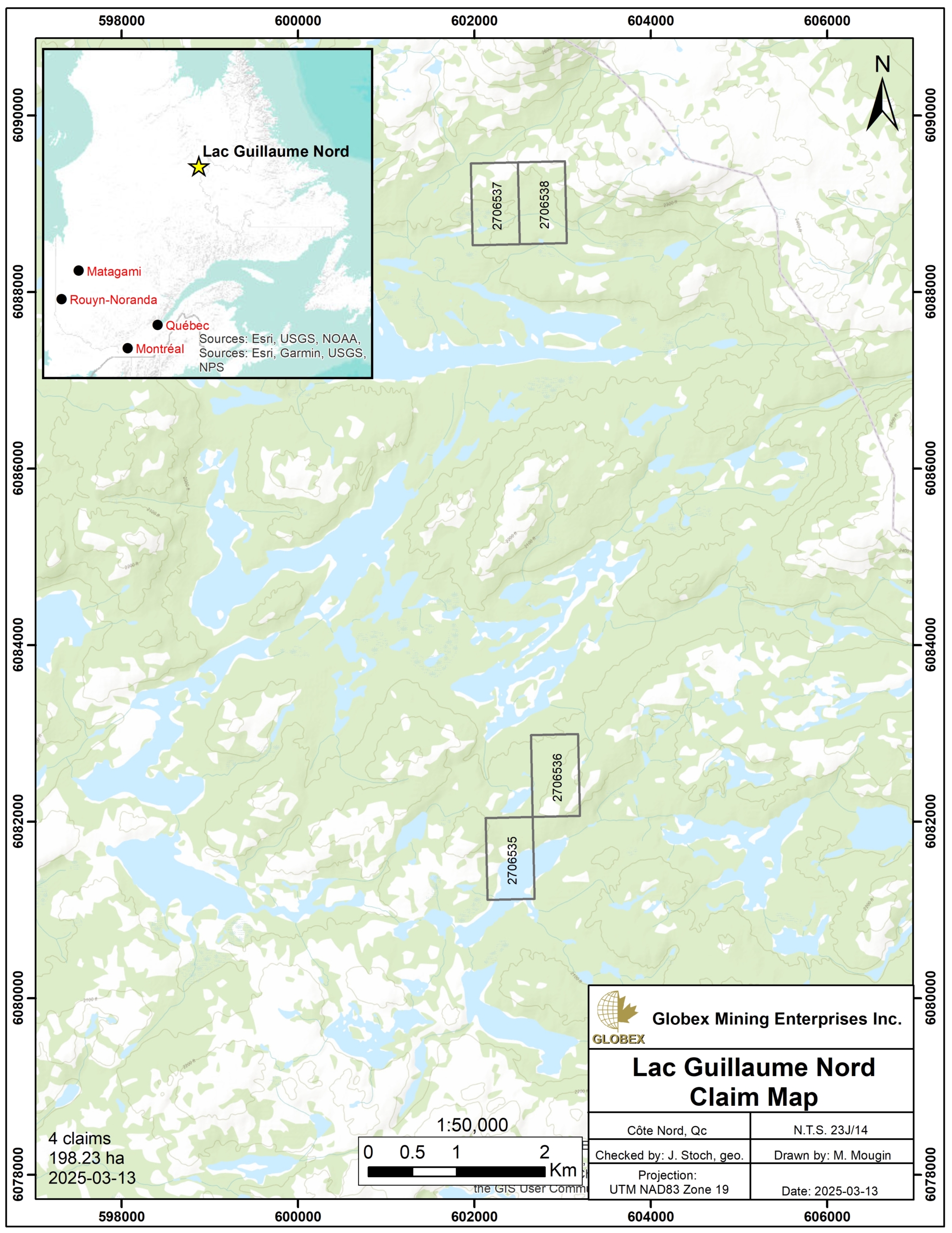
The Lac Guillaume Nord property is located in the Nunavik Territory, MRC of Kativik, in Nord-du-Québec region, about 40 km west of Schefferville. The property consists of 4 mining claims covering 198.23 Ha in NTS 23J14. The claims are owned by Jean Robert and Globex will retain a 1.5% Gross Metal Royalty (GMR) on any subsequent production.
The property is located on public lands where exploration is allowed without specific restrictions. The only way to access the Lac Guillaume Nord property is by helicopter or seaplane since no road links between Nunavik and southern Quebec.
Geology and Mineralization
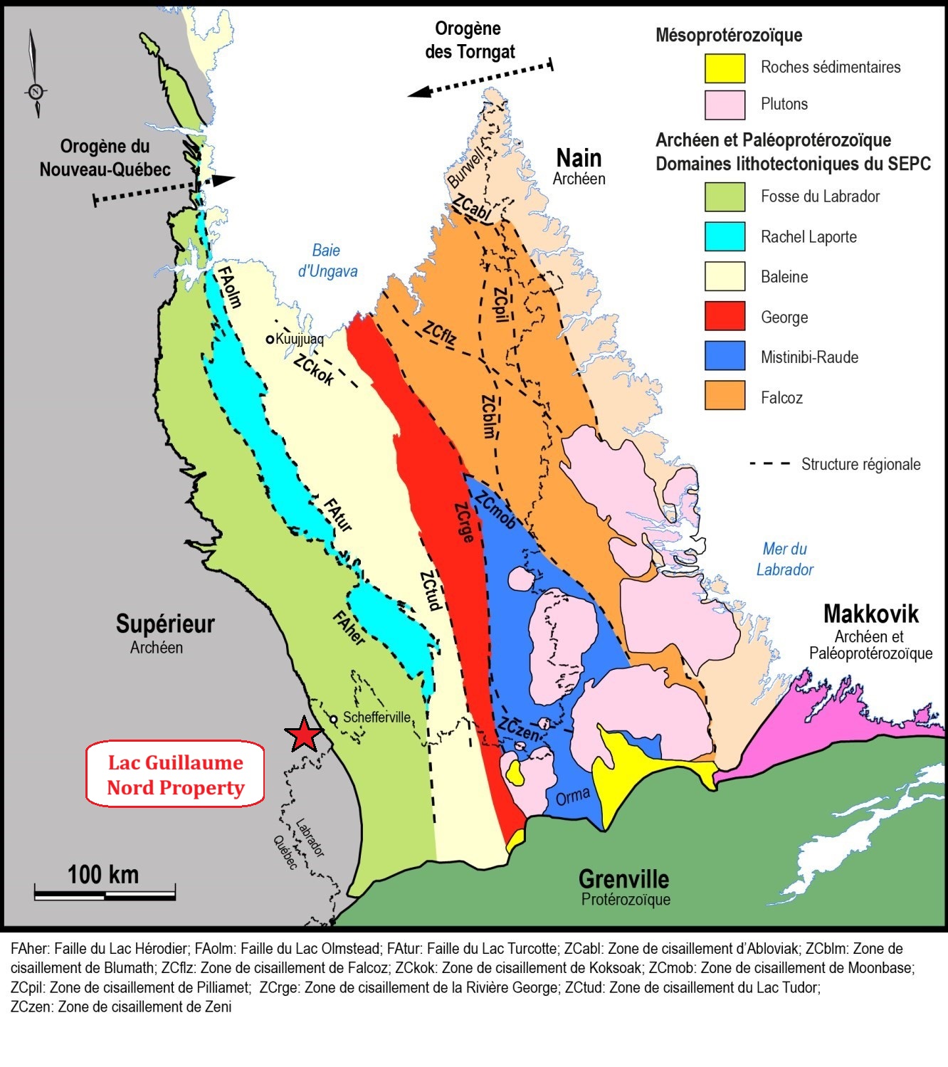
The property is located in the Ashuanipi Subprovince of the Superior Province of the Canadian Shield, near the contact the Churchill Province to the east. The Ashuanipi Subprovince is an Archean domain of high metamorphic grade consisting of ancient units (< 2,725 to 2,680 Ma) of metasedimentary rocks, volcanic rocks, tonalitic and granodioritic intrusions, and, to a lesser extent, mafic to ultramafic rocks. The ancient units are cut by voluminous masses of diatexite (2,680 to 2,660 Ma) which are the product of the partial melting of the ancient units, mainly paragneiss.
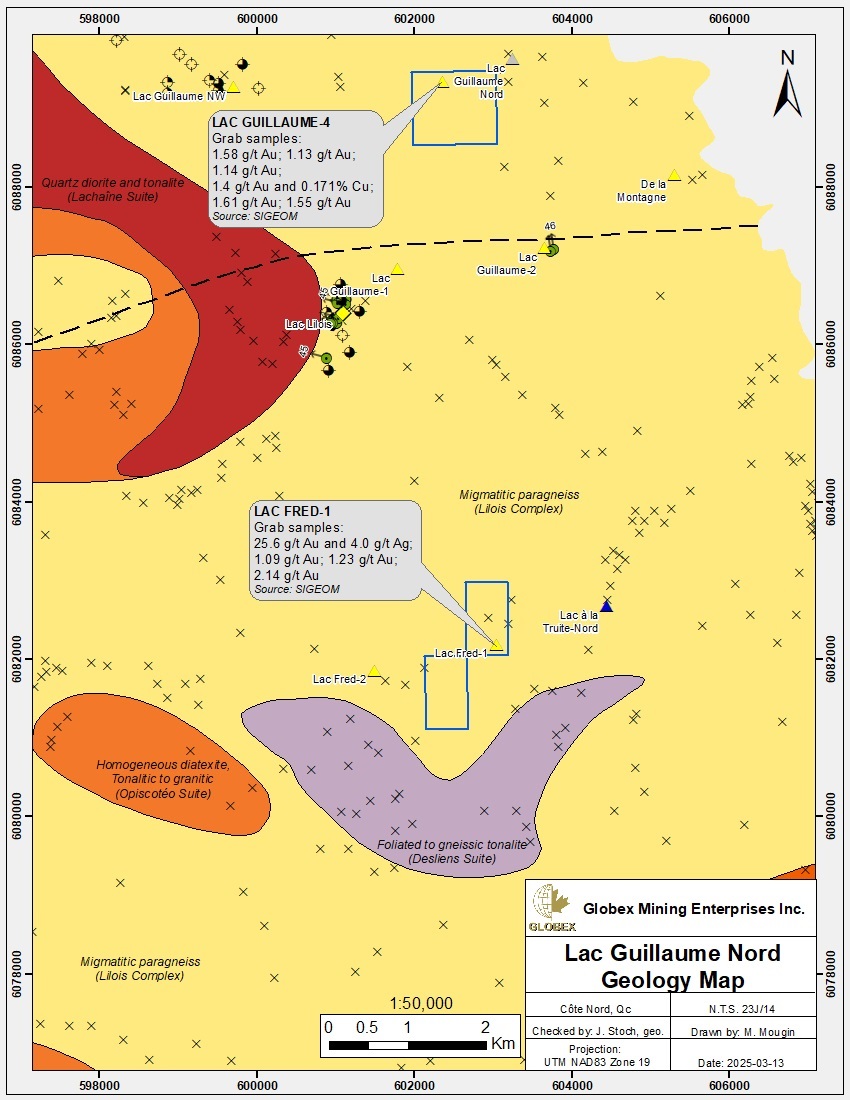
Most of the Lac Guillaume Nord property is underlain by metamorphic rocks (paragneisses and metatexites) of the de Lilois Complex. The migmatitic paragneisses exhibit heterogeneous and irregular banding, ranging from millimeters to meters in width, resulting from alternating bands of grayish paleosome (paragneiss) and whitish leucosome (MM 2015-01). This unit is characterized by the presence of numerous iron formations which often host gold mineralization.
The iron formations are mostly of the silicate facies and form boudinated lenses that can reach several meters in thickness. They are found in the migmatitic paragneiss and the rusty patina makes them distinctive in outcrop.
The general foliation is oriented NNW, parallel to the contact with the Labrador Trough. Several thrusts and folds concordant to the regional foliation are recognized in the property area. Many ductile deformation phases lead to a dome-and-basin folding. The complex regional folding could lead to the thickening of the mineralized lenses. The area is affected by a relatively uniform granulite-facies metamorphism.
In 2015, Simard et al. (MM 2015-01) identified four (4) types of mineralization which can be found in ornear the Lac Guillaume Nord property : 1) Iron formation-hosted gold; 2) disseminated Au-Ag; 3) gold associated to arsenopyrite in quartz vein and 4) Pb-Zn mineralisation.
From an economic perspective, the most important rocks in the Ashuanipi are the iron formations. These were deposited in one or several large sedimentary basins between 2,725 and 2,680 Ma. These former Algoma-type silicate iron formations are metamorphosed into a dominantly silicate facies composed of various proportions of magnetite, pyroxene, garnet, quartz and sulphides and host most of the known the gold mineralization.
Several gold showings are recognized in the Lac Guillaume Nord property area which all been discovered by surface prospection in 1986 – 1987 (GM 44729, GM 44730 & GM 45903). Mineralization is predominantly disseminated in quartz-bearing paragneisses and silicate iron formations. In most of the occurrences, gold is associated less than 10% disseminated sulphides containing arsenopyrite. The preferred genetic model is a metamorphic mobilization of gold in the iron formation as it is interpreted at the Lupin gold mine (Bullis et al., 1993).
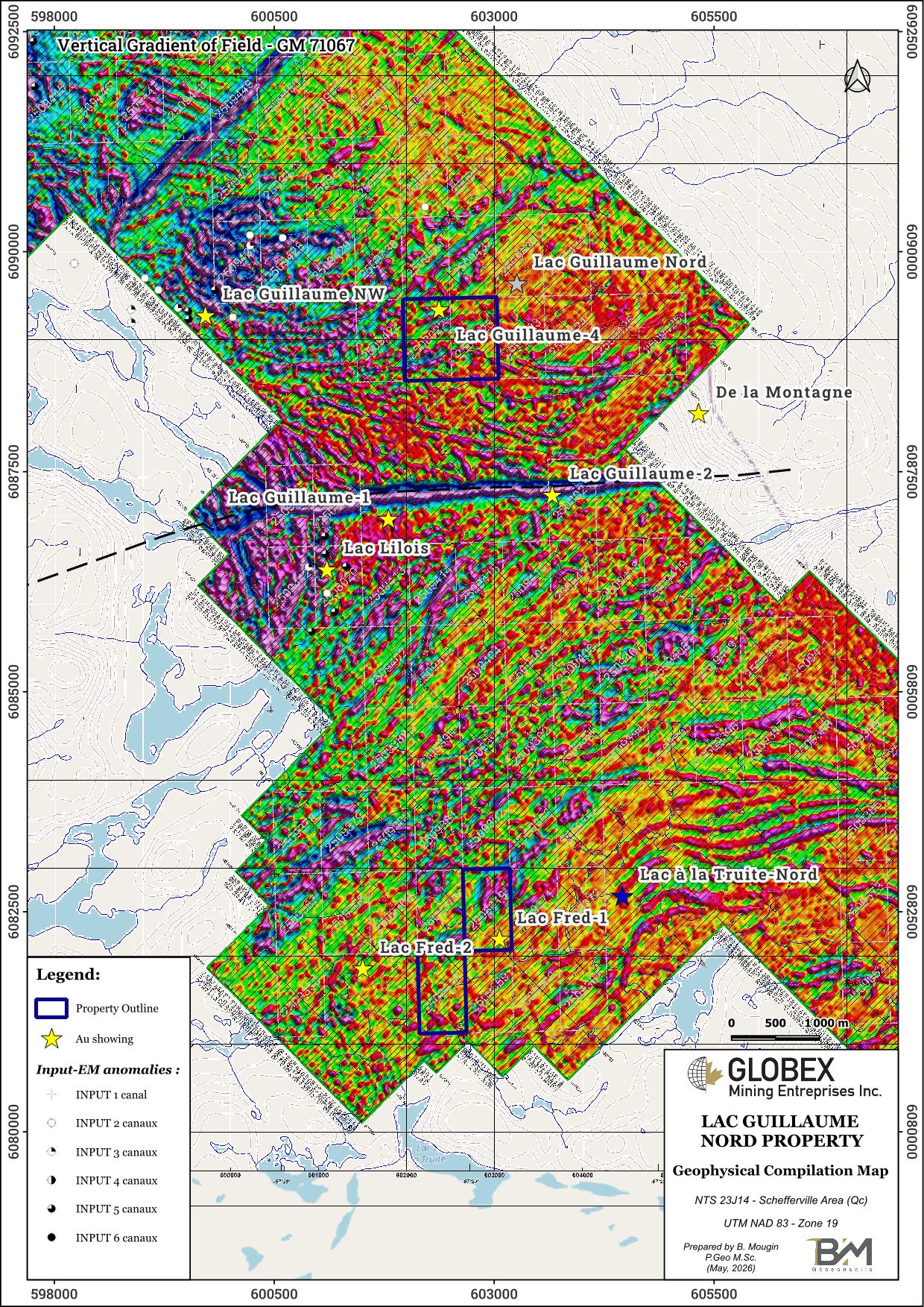
Known showings on and out of the property in this area don’t particularly appear to be associated with magnetic anomalies.
History
Prior to 1983, exploration work in Schefferville focused on iron ore from the Labrador Trough and therefore little attention was given to the area outside of the Proterozoic belt. In 1985-86, the Ministry of Natural Resources (MRN) deployed significant efforts to evaluate the economic potential of the area. A stream sediments survey (DP 86-23) and a Geotem survey (DP 87-04) covered the area. However, it is the discovery of the Canoe Lake gold (Au) occurrence and other arsenopyrite-bearing lenses by Lapointe (MB 85-73), that triggered interest in the area.
In 1995, a few silver and gold occurrences, also associated with iron formations, were found during prospection following a stream sediments survey (GM 54190). Despite the publication of a metallogenic synthesis of the northeast Ashuanipi Subprovince by the MRN (MM 95-01) and the whole sub-province (MM 2015-01), there was a hiatus in exploration in the area from 1995 until 2010.
A total of 15 DDH (1,181 m) have been drilled in the area of the property, mostly in 1987 (GM 45903, GM 45905 and GM 66613). Anomalies up to 1.19 g/t Au over 5.0 m and 1.45 g/t Au over 3.8m were intersected at the Lac Lilois gold showing. No DDH have been drilled within the property limits.
Recent work :
In 2018, Albert Mining flew a high-resolution heliborne magnetic survey on the Ashuanipi Project (GM 71067). The survey covered the current Globex’s royalty claims.
In 2021, Flow Metals Corp. carried out geological reconnaissance on the Ashuanipi Project (GM 72597) including bedrock and till sampling based on the Artificial Intelligence (Al) Computer Aided Resource Detection System (CARDS) targets (GM 71172). Anomalies up to 25.6 ppm Au were observed in the area of the La Fred-1 showing and up to 1.58 ppm Au in the area of Lac Guillaume-4 during this program.
Resources and Potential
Due to very few historical exploration work by private mining compagnies, the true gold potential of the property is still to be discovered. Limited drilling was carried out in the area and no DDH are located within the property limits so the extent of mineralization at depth remains unknown. Historical drilling at the Lac Lilois gold showing intersected up to 1.19 g/t Au over 5.0 m and 1.45 g/t Au over 3.8m (GM 45903). The main difficulty lies in the discontinuous nature of mineralization due to boudinage deformation of the rocks.
As gold is generally associated with up to 10% sulphides on the known showings of the area, induced polarization (IP) appears to be a well appropriated indirect method to highlight new mineralization in surface. As the mineralization is preferentially associated with iron formations, the IP survey should target areas showing strong positive magnetic anomalies on the 2018 heliborne survey. A detailed GIS compilation of historical geoscientific data should help to further explore the known showings and plan new geophysical surveys, strippings and eventually DDH.