
Lac Gwillim Gold
Location, Access, Description
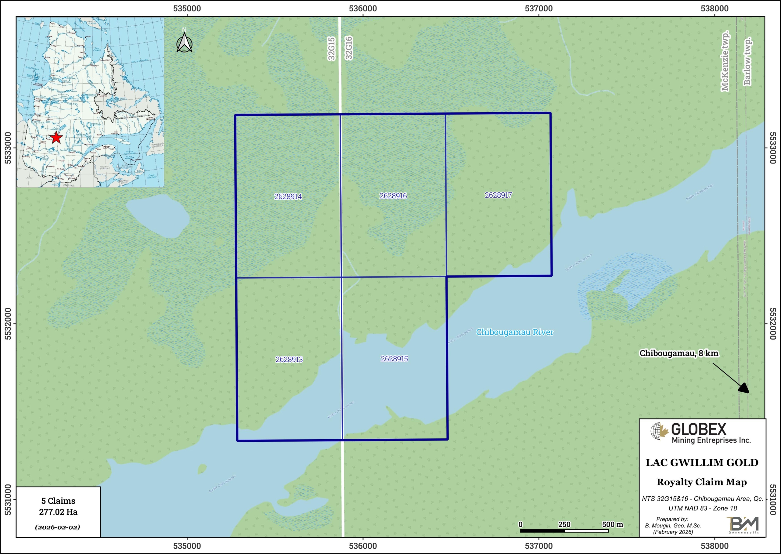
The Lac Gwillim Gold property is located in Eeyou-Istchee James Bay Government, Northern Québec, Canada (NTS 32G15 & 16), approximately 8 km northwest of Chibougamau. It consists of 5 contiguous claims covering a total area of 277.02 hectares in Barlow township. The Project is easily accessible in vehicle by all-weather gravel roads connecting to regional highway #167.
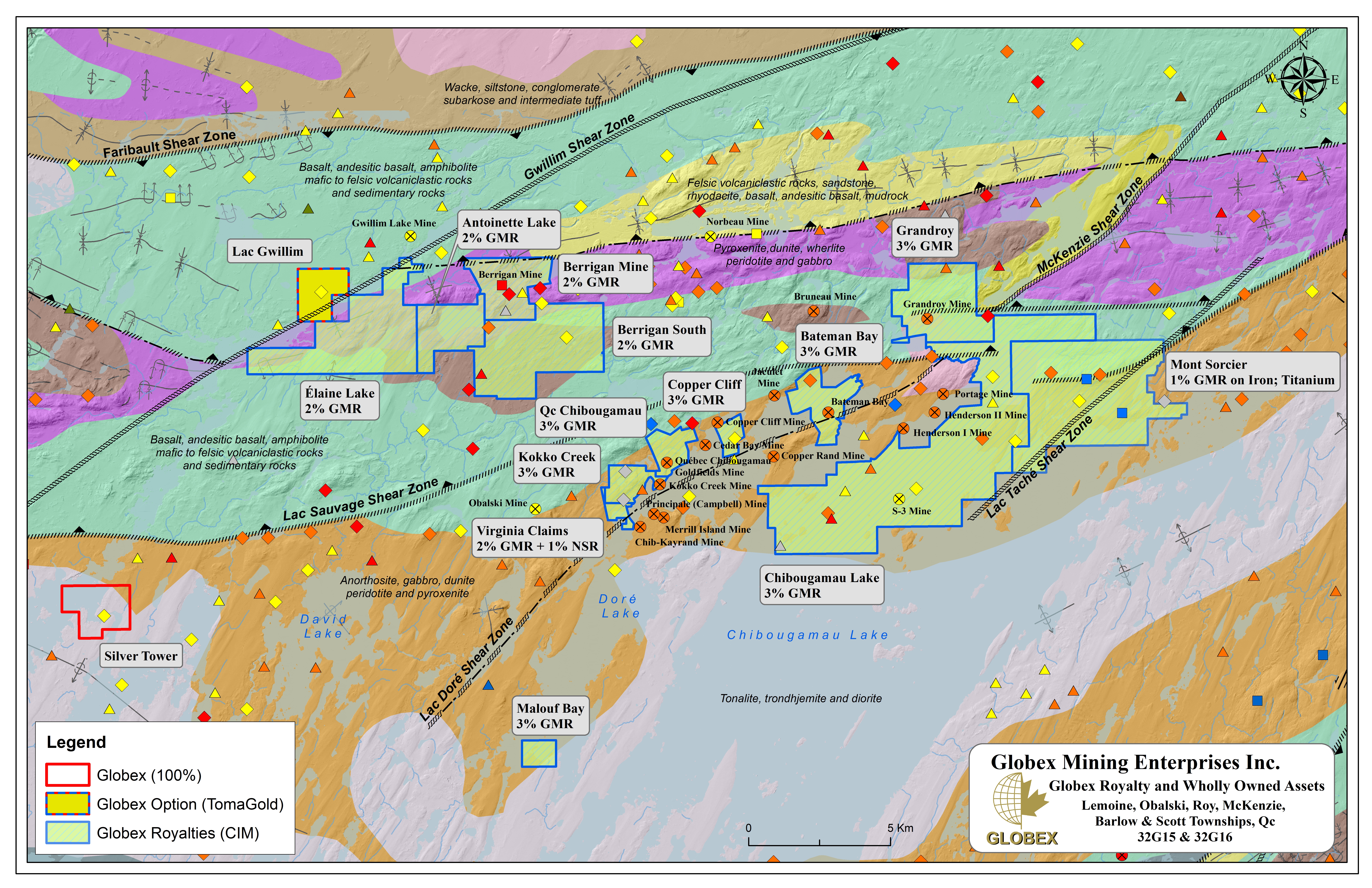
The claims are 100% owned by Globex ; TomaGold optioned the property in 2023 and Globex will retain a 2% Gross Metal Royalty (GMR) on these 5 claims.
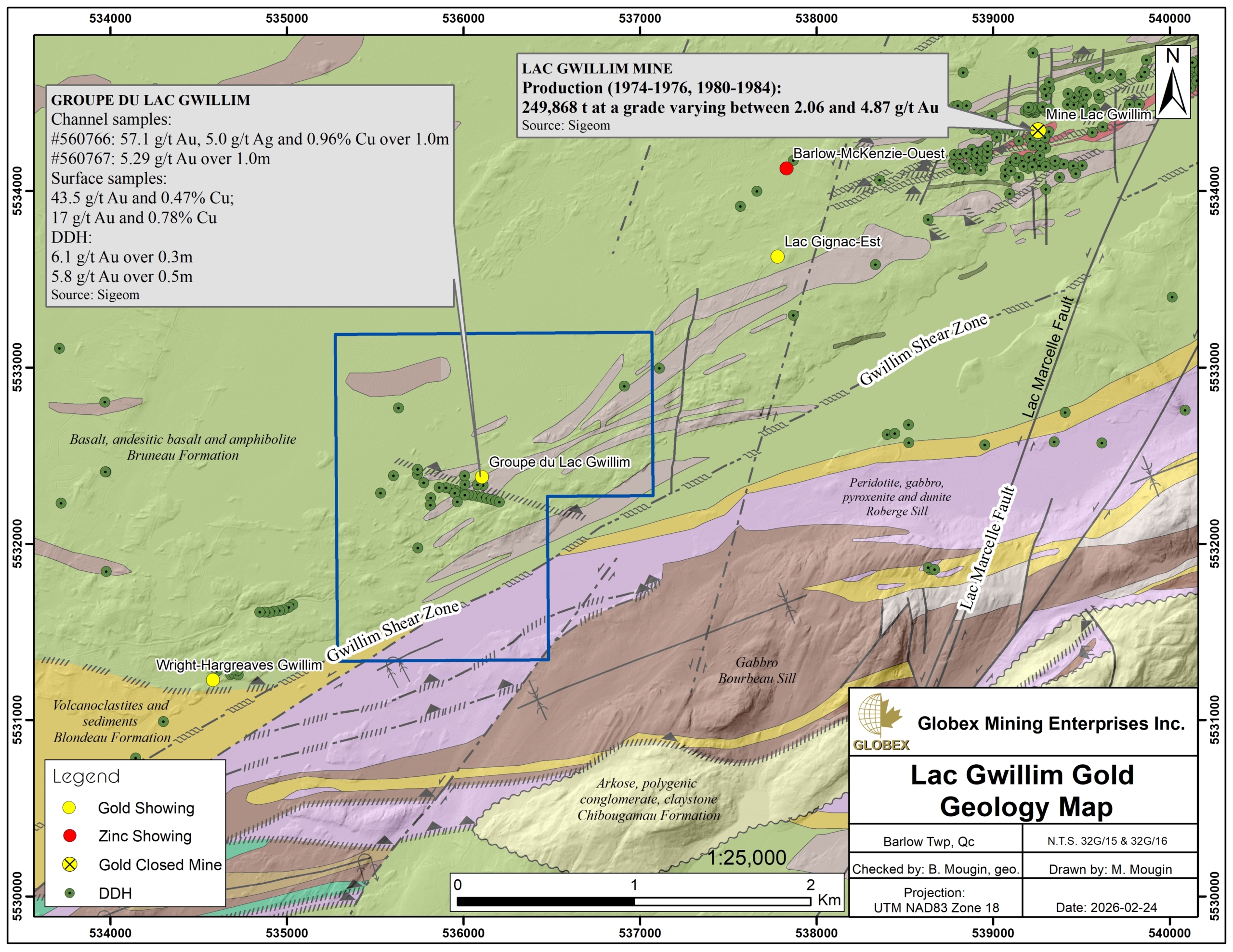
The Gwillim Lake Mine located 2.5 km northeast of the Lac Gwillim Gold property, produced 249,868 t grading 4.87 ppm Au and 5.08 ppm Ag between 1980 and 1984, until reserves were depleted (DV84-06).
Geology and Mineralization
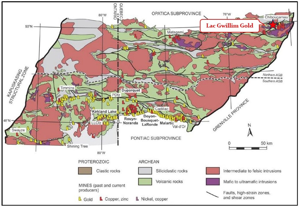
The Lac Gwillim Gold property is located in the Superior Province of the Canadian Shield. The Abitibi Sub-province is known for its prolific and diverse rich mineral deposits; total gold production of the Abitibi Greenstone Belt (AGB) since the beginning of the 20th century is estimated at over 210 million ounces (Moz) Au (Dumas, 2024).
The Chibougamau region hosts some of the eldest rocks of the AGB; the area is dominated by a stacking of Archean mafic volcanic rocks intercalated with a few felsic units and some sedimentary units, intruded by two large batholiths : the anorthosite Doré Lake Complex, and the Chibougamau Pluto composed of tonalite and granodiorite. These two intrusions played a major role as regional mineralized features, and the vast majority of mines in the Lake Chibougamau area are located within or near these two intrusions. Regional metamorphism is at the greenschists grade.
The Chibougamau Mining District is located in the northeastern part of the Abitibi Greenstone Belt and hosts a variety of deposits styles; Leclerc et al. (2012) documented volcanogenic massive sulphide (“VMS”) deposits, magmatic Fe-Ti-V and Ni-Cu ± PGE mineralization, early polymetallic (Au-Ag-Cu-Zn-Pb) vein deposits (to which the Property mineralization might belong), Chibougamau-type Cu-Au-veins, shear zone-hosted Au deposits, and Opemiska-type Cu-Au veins. Total production of the Chibougamau mining camp since the beginning of the 20th century is estimated at 1,624.9 Mlbs Cu and 3.22 Moz Au (Houle, 2019).
The Lac Gwillim Gold property is mostly underlain by ENE-oriented mafic volcanics of the Bruneau Formation, intruded by concordant Archean gabbro sills. The Cummings Suite is composed of three distinct ultramafic to mafic sills named, from bottom to top, the Roberge, Ventures, and Bourbeau sills. In the Gwillim shear zone, the felsic tuffs and sediments of the Blondeau Formation are in abnormal contact with the peridotites of the Roberge sill. On a regional scale, these sills contain significant hydrothermal mineralization. Historical Resource of 1.39 Mt grading 3.17% Zn and 1.77 g/t Au has been estimated by Chouinard et al. (2001 – GM61359) at Berrigan, and TomaGold recently discovered new massive sulphide mineralization below the known zones (TomaGold press release dated January 29, 2026).
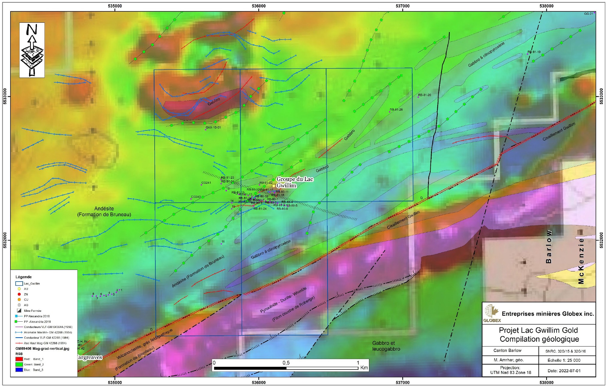
The property covers the Gwillim shear zone over a length of approximately 1.3 km and hosts the Groupe du Lac Gwillim gold showing. Mineralization is of the orogenic lode gold type. The “Cadillac” vein consists of milky and smoky quartz with ankerite, chlorite, sericite, tourmaline, and varying amounts of pyrite with traces of chalcopyrite. It has been stripped over a length of 46 m and is between 15 cm and 1 m wide, intensely brecciated and altered to silica-carbonate-hematite. Historical sampling from the central part of the vein contained up to 57.1 g/t Au over 1 m in a channel sample and 13,600 ppb Au over 0.42 m in a 1980 drill hole (GM 37402).
History
Discovery of metallic mineralization in this area dates back to 1929 with the discovery of the “Lac Berrigan South Zone” in surface prospection. Numerous exploration programs (mapping, sampling, geophysics, diamond drilling…) have been undertaken by successive owners. the “Groupe du Lac Gwillim” gold showing was discovered in 1952 by surface prospection and rock stripping. Detailed history of exploration on the Lac Gwillim Gold property is presented in Amrhar (2023 – GM73793).
The Gwillim mine was a gold producing mine in the 1970s and 1980s, producing 220,000 metric tonnes at a grade of 4.87 g/t Au and 0.07% Cu. Exploration and development stopped in 1989 at Gwillim because of the owner’s other commitments. Remaining historical resource (non 43-101 compliant) is estimated to 307,410 tonnes grading 10.2 g/t Au (Tanguay, 2018 – GM71169).
The Gwillim mine was a gold producing mine in the 1970s and 1980s,producing 220,000 metric tonnes at a grade of 0.07% Cu and 4.87 g/t Au. Exploration and development stopped in 1989 at Gwillim because of the at the time owner’s other project commitments. The remaining historic resource is all contained within the KOD zone and stands at 307,410 tonnes at a grade of 10.2 gt in a non 43‐101 compliant resource (internal report).
A total of 2,859 linear metres in 31 drilling holes have been documented on the Lac Gwillim Gold property in Quebec public data (Sigéom); most of the drilling has been focused on the “Groupe du Lac Gwillim” gold showing and dates back to 1981 and earlier.
Between 2004 and 2018, Alexandria Mines carried-out a series of work including prospection and geological mapping, several geophysical surveys (mag, EM, IP), soil geochemistry, till sampling, as well as one (1) single DDH hole in order to test a magnetic anomaly (GM65261). This work highlighted moderate chargeability anomalies, some of which being concordant with resistivity highs and EM anomalies. Five (5) diamond drill holes (DDH) were proposed to verify the priority 1 anomalies; these holes do not appear to have been drilled so the targets remain unverified until today.
Recent developments :
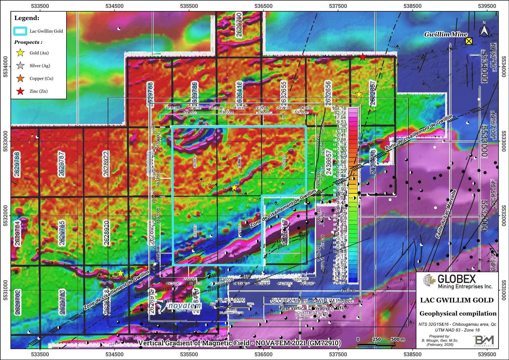
In 2022, Globex requested the services of NOVATEM to fly a very-high resolution airborne magnetic survey over the Lac Gwillim Gold property (GM72913).
In 2023, Globex prepared a compilation of geology, metallogeny and historical work of the Lac Gwillim Gold property (GM73793). Surface data from geophysical surveys was compiled in a GIS project and highlighted several concordant anomalies which constitute interesting targets for rock stripping and DDH.
Resources and Potential
Exploration in the area identified a regional favorable context for several commodities including gold, zinc and silver. The property potential is supported by favourable geological and structural setting and the presence of well-documented metallogenic and litho-tectonic elements such as the Lac Gwillim shear zone, the layered mafic-ultramafic sills of the Cummings Complex, felsic volcanic and volcanoclastic rocks of the Blondeau Formation, and other structures and alteration (Carrier, 2022).
In particular, the property is located in strike with the former Gwillim gold mine. Historical work highlighted several geophysical anomalies in the northwestern half of the property which have not been systematically tested in DDH; these anomalies still represent interesting targets. Further geophysical work would help to refine the targets and confirm their exact location in order to plan new rock stripping and DDH.
The Cummings mafic and UM sills also host a significative exploration potential for polymetallic mineralization on the Lac Gwillim Gold property. TomaGold has recently intersected new massive sulphide mineralization on the Berrigan Mine property located to the west. In a press release dated January 29, 2026, TomaGold stated that “Drill hole TOM-25-015, grading 5.75% ZnEq (1.34 g/t AuEq) over 98.5 m, is truly transforming the Berrigan Mine project and highlights a new semi-massive sulfide zone that extends at depth beneath the known zones. This very encouraging result suggests the presence of a large mineralized system that remains open at depth.”