Leman
Location, Access, Description
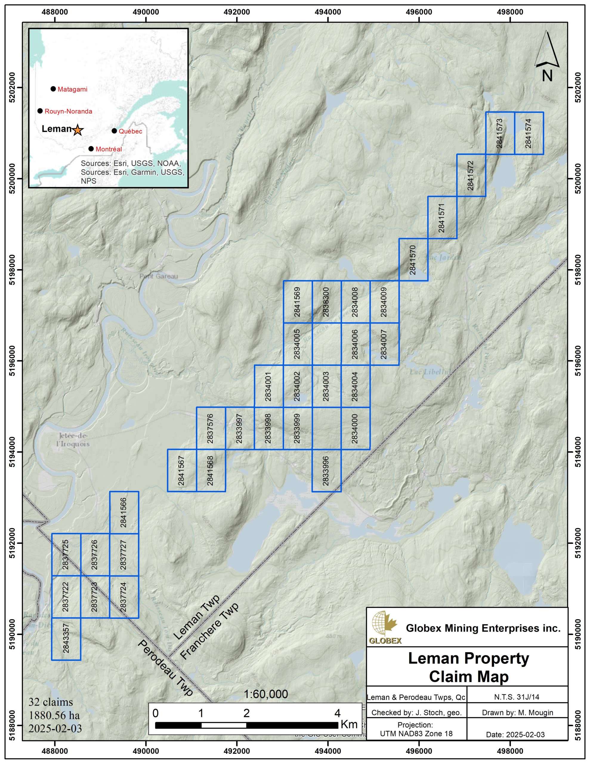
The Leman property consists of 32 claims covering an area of 1,180.56 Ha in NTS 31J14, approximately 45 km northeast of Mont-Laurier, Quebec. The claims are wholly owned by Globex Mining Enterprises Inc. and are located on public lands where exploration is possible without restriction. The claims are not subject to any third-party agreements or royalties.
Access by road is possible from Mont-Laurier (Qc). One needs to drive north on road 309 to Mont-Saint-Michel, then on Road 311 to Lac-St-Paul. Finally, the Chemin du Pérodeau trail leads to the property further 21 km northeast.
Many commodities can be found in Mont-Laurier regarding contractors, equipment rental, as well as sleep and food accommodation of remote workers. A hydro power line strikes approximately N-S about 16 km east of the property.
Geology and Mineralization
Regional Settings
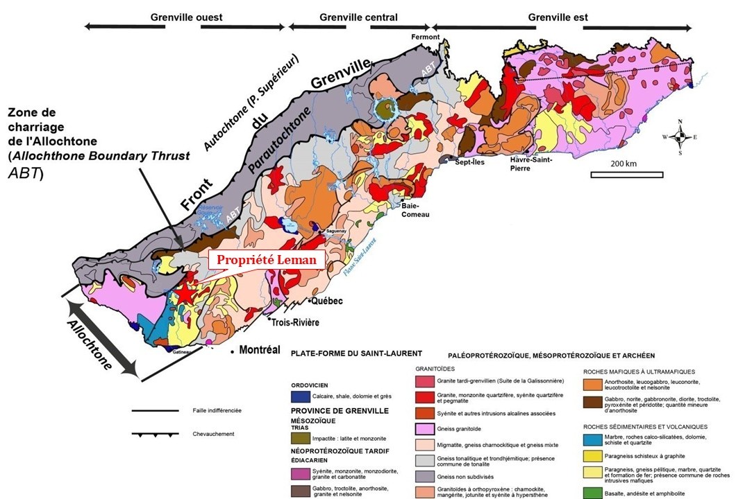
The Leman property lies within the Grenville Province of the Canadian Shield. The Grenville constitutes the deep root of an ancient chain of mountains comparable to the Himalayas (Windley, 1986). The area of Sheet 31J14 is part of the Allochthonous Belt, made up of all the Grenville rocks lying south of the Parautochthonous (Rivers et al., 2012). It is bounded to the south by the Paleozoic-aged rocks of the St. Lawrence Platform and Appalachians.
The Allochtone is composed of detrital, pelitic and carbonate rocks of Paleoproterozoic to Mesoproterozoic age (1.6 to 0.985 Ga ; Rivers et al., 1989 ; Friedman and Martignole, 1995 ; Martignole and Calvert, 1996). Juxtaposition of the Allochthonous on the Parautochthonous occurred during the Grenvillian orogenic cycle (1,900 to 986 Ma).
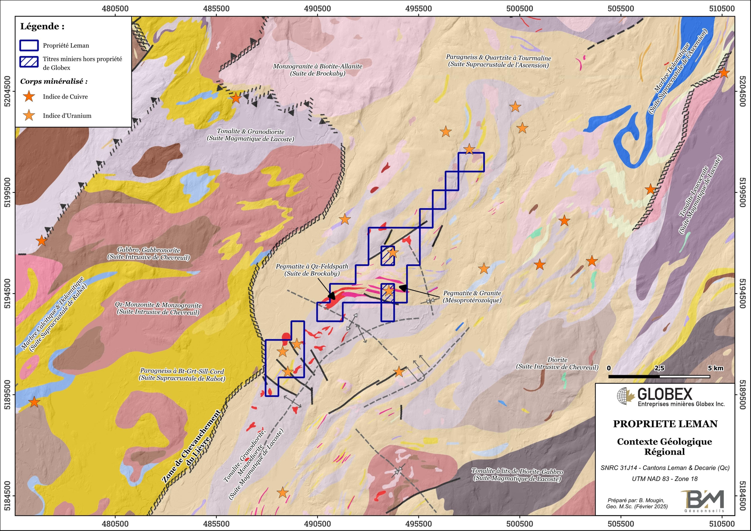
The Mont-Laurier terrane consists of platform marble, quartzite and pelite and amphibolite layers of Mesoproterozoic age, intruded by gabbro sills and felsic and mafic intrusions, some of which are ultrapotassic in composition. In the area of the property, the Mont-Laurier terrane is divided into two lithotectonic domains separated by the Lièvre Overthrust Zone: the Cain Domain to the west, metamorphosed to the granulite grade, and the Baker Domain to the east, metamorphosed to the upper amphibolite grade.
Kinematic indicators in the felsic rocks of the Cain Domain indicate that it overlaps the Baker Domain (Nantel, 2001), to which the Leman property belongs. The Lièvre Overthrust Zone is NNE-SW trending, with an estimated thickness of around 2,000 metres, and represents the major structural lineament in the region. This event probably triggered the partial melting of the feldspathic paragneisses of the Ascension Metamorphic Suite and the remobilization of uranium (1,150 Ma).
Property Geology
The Leman property is located in the Baker Domain of the Allochtone, immediately east of the Lièvre Overthrust Zone. Rocks of the property belong essentially to the Ascension Supracrustal Suite, the Lacoste Magmatic Suite and the Brockaby Suite.
The Ascension Suite is composed of medium-gray to light-gray, locally rusty, finely banded paragneiss, represented mainly by biotite feldspathic paragneiss (<15% quartz) and biotite ± graphite quartzo-feldspathic paragneiss (Nantel, 2008). Locally, the paragneiss contains garnet and muscovite.
The Lacoste Suite consists of undifferentiated biotite-hornblende rocks including a dominant tonalite and gray granodiorite, as well as diorite and locally quartz-diorite. The unit includes a small proportion of gabbro enclaves and levels of amphibolite and gabbro. The tonalite is locally cut by veins or dykes of granite and pegmatite.
The Brockaby Suite is generally characterized by massive, fine- to medium-grained, pink, equigranular, hololeucocratic monzogranites containing 5-10% biotite and locally traces of magnetite (Nantel and Pintson, 2001). On the Leman property, the rocks of the Brockaby Suite are represented by quartz-feldspar ±biotite pegmatites that crosscut the rocks of the Ascension Suite.
Granite dykes and pegmatites are present on the property. Nantel (2001) describes that “in the vicinity of Lac de la Hache and Lac Iroquois and near the thrust zone, the orthogneisses are cut by clusters, not dykes, of pink pegmatite often associated with fine-grained pink monzogranites. As for the paragneisses, they are intersected by the same type of fine-grained monzogranite, but generally gray instead of pink in color”. The relationship between pink pegmatites and fine-grained pink monzogranites is complex.
Regional Metallogeny
Numerous mineral occurrences and deposits have been recognized in the northern part of the Central Metasedimentary Belt of the Grenville Province. The two (2) main commodities found in this area are uranium (U) and copper (Cu). Nantel (2001) defines four (4) main types of metallic deposits in this area :
- Copper mineralization associated with mafic intrusions
- Copper mineralization associated with metasedimentary rocks
- Uranium
- Graphite and Wollastonite.
Property Mineralization
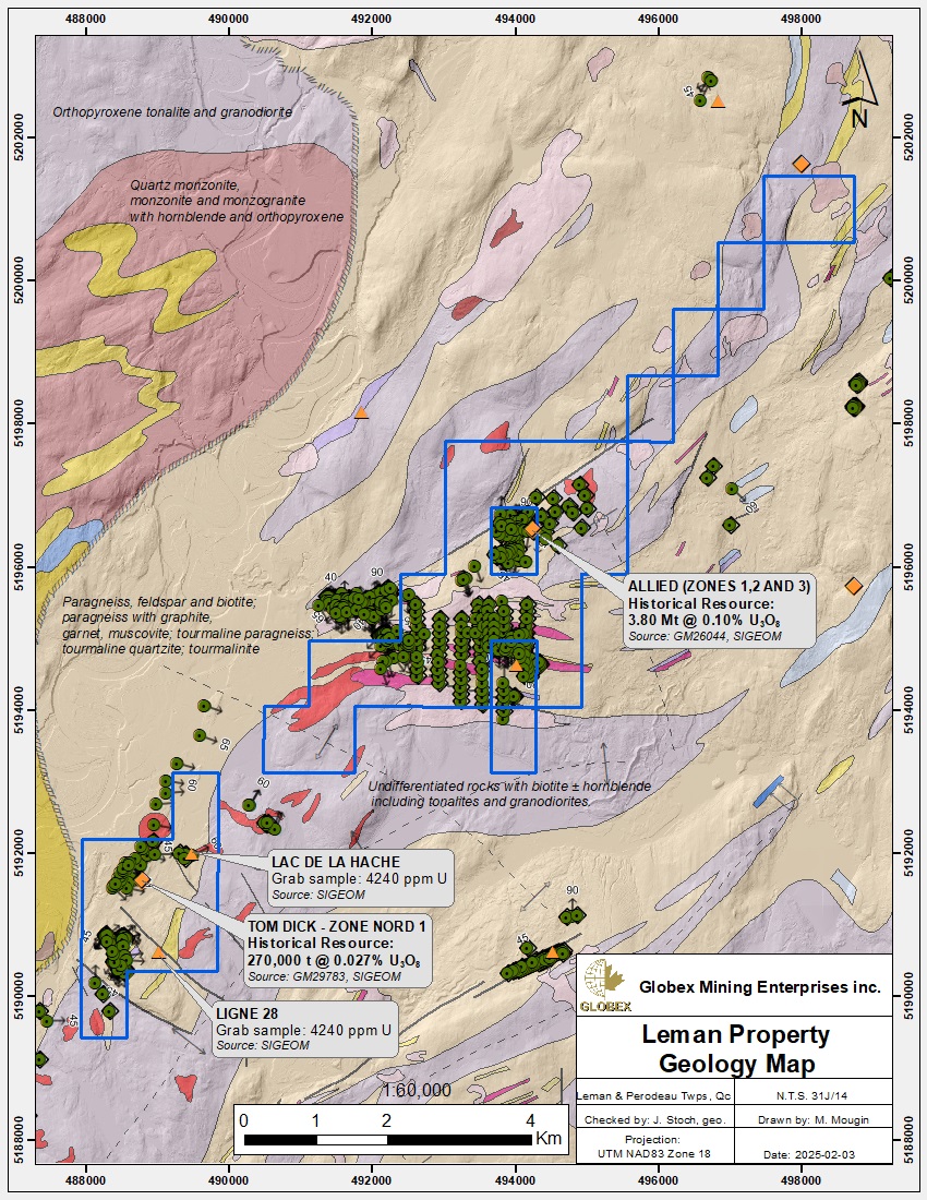
Several uranium showings are located on and around the Leman property. Areas of radioactive interest are mainly found in the white metamorphic pegmatites. The contact between white pegmatite and quartzite also has potential as a radioactive zone.
The Tom Dick showing is located in the SW part of the property. Disseminated pyrite, pyrrhotite, uraninite, uranothorite and uranophane mineralization occurs within pegmatites and quartzite. Historical drilling defined a mineralized zone measuring 900m by 42m in NE-SW elongation. Grab samples returned 0.025 to 0.175% U3O8 (GM 29985).
The Lac de la Hache showing lies approximately 800m northeast of the Tom Dick showing. Mineralization consisting of uraninite, pyrrhotite, molybdenite and chalcopyrite is disseminated in metasediments. A grab sample returned 4,240 ppm (0.424%) U (GM 29985).
The Line 28 showing is located approximately 1km south of the Lac de la Hache showing. Disseminated mineralization is hosted by metamorphic pegmatite in biotite gneiss. Sampling over a width of 1 m in a historical trench returned 0.12 to 0.2% U3O8 (GM 29985).
The Mekoos and Allied showings are located in the heart of the Leman property, but on claims which are not held by Globex. At Mekoos, a radioactive mineralized zone has been defined over 450m in a N045° to N090° trend. Disseminated mineralization is hosted by metamorphic pegmatite in impure quartzite, calcosilicate rock and biotite gneiss. Mineralization consists of uraninite, uranophane and titanite. It shows small idiomorphic uraninite crystals. Grab samples returned up to 1.4% U3O8. The Allied showing is hosted by a white metamorphic pegmatite in hornblende-biotite gneiss (GM 58948). A stratiform body measuring 1,200m by 300m and trending N225/-20° was explored by 34 shallow drill holes. Assays of up to 1,338 ppm U and 117 ppm Th over 1.5 m were reported in channel samples.
The JRB-4 Lafargue showing is located at the northern boundary of the property. A band of pegmatite bearing uranium mineralization is interbedded between chloritized hornblende gneiss (top) and marble (base). It is 0.6 to 0.9 m wide and can be traced for around 14 m in an ESE orientation. Grades of up to 1.14% U3O8 were obtained from grab samples (GM32801).
History
The author refers to the NI43-101 technical report by Hawkins and Dallaire (2013; GM68532) for detailed information on the property’s work history.
The Leman property has been the subject of numerous and varied exploration efforts carried out by different players over time. This work began in the 1960s and led to the discovery of numerous uranium showings in the region.
Uranium mineralization was first discovered in the Mont-Laurier area in 1967 by a prospector named L. Lavoie, when a grab sample returned a value of 2 lbs/tonne (about 1,000 ppm) of uranium oxide (U3O8). This sample attracted the attention of Canadian Johns-Manville Company Ltd. (“CJM”), which subsequently explored the Mekoos region in detail. Following CJM’s discovery, a number of other companies and prospectors explored the Mont-Laurier area for uranium. Exploration of this area took place in two phases, the first extending from 1969 to 1989, followed by a second phase in the 2000s.
Thus, while CMJ (1969-1977) and SOQUEM (1978-1982) were exploring the Lac à l’Ours region (Mekoos showing), Mont-Laurier Uranium Mines (1969-1972) and SOQUEM (1973-1982) were simultaneously exploring west of Lac de la Hache. This work led to the discoveries of the Tom Dick, Line 28 and Lac de la Hache showings. United Asbestos Corp. & Allied Mining Corp. (1969-1970) and Bomet Mines Ltd. (1976-1985) were focusing at the same time on the Allied showing area. Subsequently, between 2005 and 2007, Nova Uranium Corporation resumed exploration of the entire favourable area, carrying out new airborne magnetic and radiometric surveys.
It is mentioned in bibliography, that uraninite and uranophane (±uranothorite) mineralization is fairly discontinuous and occurs mainly within horizons of white pegmatites intercalated with calcosilicate rocks and gneisses. Mineralization appears to have occurred in two stages: 1) uranium was initially pre-concentrated in the original sediments at the base of the Grenville Group; 2) during regional metamorphism, uranium (±thorium) was redistributed and concentrated in the anatectic pegmatites. The latter are hosted by the tonalitic orthogneisses of the Lacoste Suite and the metasediments of the Ascension Suite. Structural analysis undertaken by SOQUEM in 1981 suggests that the mineralization forms lenses that may be related to the hinge zones of folds from different phases of deformation (GM37410).
Several historical resource estimates not compliant with the current National Instrument 43-101 have been made on the various mineralized zones of the Leman property. In 1972, Mont-Laurier Uranium Mines carried out a bulk sample of 500 lbs (227 kgs) of ore that returned 1.20 lbs/t (approx. 0.05%) U3O8 on the North Zone (Tom Dick), west of Lac de la Hache (GM28205). In 1977, Bomet Mines used drill results to estimate an average grade of 0.87 lbs/t (0.04%) U3O8 in the Allied sector (GM33410). However, the company felt that drill grades were not representative of the sector’s true economic potential, and that bulk sampling would be a more appropriate method for the type of mineralization observed. To test this theory in 1979, following a new 1,540-metre drilling campaign, Bomet took six (6) bulk samples weighing 1,000 lbs (450 kgs) each: three (3) from drill core and three (3) from surface outcrops located around the same drill holes. The results revealed an average grade of 1.9 lbs/t (0.09%) U3O8 for the surface samples, compared with 0.804 lbs/t (0.04%) U3O8 for the drill samples, i.e. approximately double (GM34839). In 1985, based on this observation, Bomet Mines estimated a resource (non-NI43-101 compliant) of 3.8Mt @ 2.23 lbs/t (approx. 0.1%) U3O8 on the Allied 1, 2 and 3 Zones (GM43425).
Historical Resources estimated on the Leman property are sub-economic in the current context.
Resources and Potential
Extensive historical work on the Leman property since the late 1960s has confirmed that it hosts a large radioactivity anomaly punctuated by several uranium showings. Uranium oxide (U3O8) mineralization is hosted by uraninite and uranophane (±uranothorite) within horizons of white pegmatites hosted by tonalitic orthogneisses and metasediments. Mineralization is discontinuous and may form lenses connected to fold hinge zones.
Bulk sampling appears to be a better method than drilling for estimating U3O8 grades in the geological context present on the property. Estimated grades, however, are below 0.1% U3O8 and therefore under-economic in the current context, especially given the lack of continuity of the mineralized zones. Despite the regional scale of the radioactivity anomaly observed, no major uranium deposit has yet been identified in the region, and it is still possible that a richer deposit may be hidden in the area. The Leman property should therefore be further explored.
Further work should consider the following recommendations :
- Locate and refresh historical trenches to observe the metallogenic context, and carry out both grab and channel sampling to confirm historical grades. Field verification should also include outcrop sampling of the two untested radiometric anomalies in the northern part of the Leman property.
- Compilation of all drilling logs into a computer database. Interpretation of this data in plan / section / longitudinal, or ideally in a 3D block model, will then enable to verify the lateral and at depth openings of known mineralized zones. New drilling targets can then be identified.
- Given that most geophysical work dates back more than 20 years, and that technologies have greatly evolved since then, new surveys will be necessary. A very high-definition helicopter-borne magnetic survey (lines spaced 25 m apart) combined with gravimetry will prove interesting for indirect mapping of buried pegmatites. Winsome Resources recently used this combination of geophysical methods to detect pegmatites buried beneath the overburden on the Cancet project in the James Bay region. New detailed spectrometry surveying would also be useful in order to refine the identification of new stripping and drilling targets..


