Marbridge South
Location, Access, Description
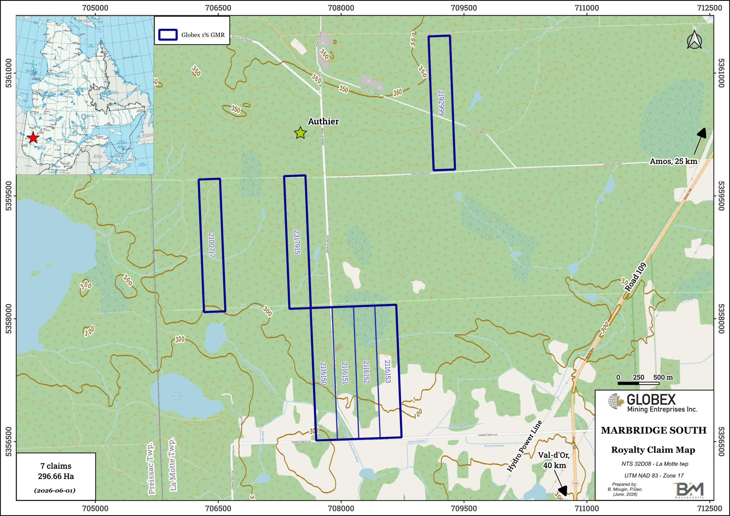
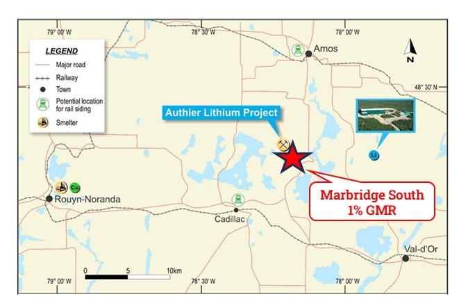
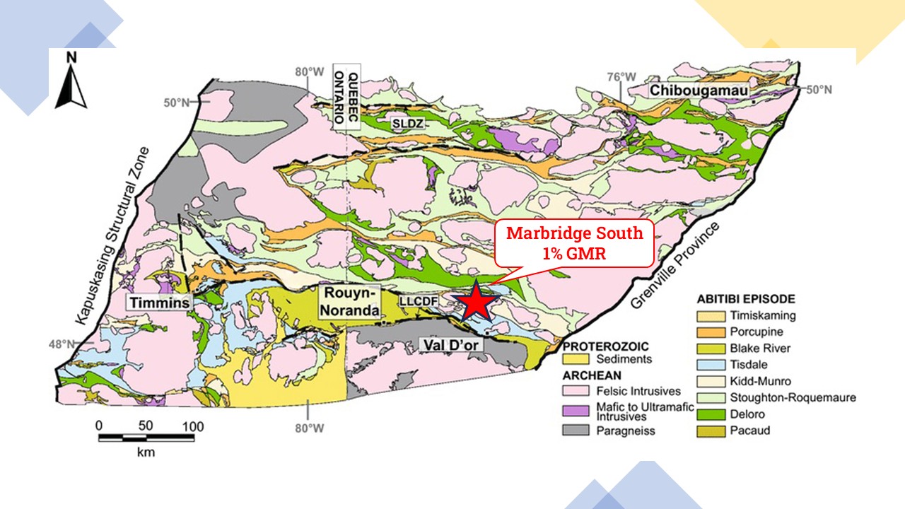
The Marbridge South property consists of 7 mining claims covering an area of 296.66 Ha in the La Motte Township of Abitibi-Temiscamingue (Quebec). The claims are located approximately 25 km south of Amos (Qc) and 40 km northwest of Val-d’Or (Qc). The claims belong to Class 1 Nickel (Somanike project), and Globex will retain a 1% Gross Metal Royalty (GMR) on any future production on these 7 specific claims. Globex also hosts 2% GMR on 15 additional claims of the Somanike project, located in the Bilson-Cubric showing area.
The property is accessible in vehicle via the 109 Provincial Road linking Val-d’Or to Amos and a network of gravel roads and exploration trails. These towns can provide remote workers with all food and sleep facilities as well as shops and contractors. A high-voltage power line runs to the east of the property.
Geology and Mineralization
The Marbridge SOuth property is located within the Abitibi Subprovince of the Canadian Shield. The Abitibi Subprovince is an Archean greenstone belt which hosts some of the richest mineral deposits of the Superior Province.; it is divided into two distinct parts (Chown et al., 1992): the South Volcanic Zone (SVZ) and the North Volcanic Zone (NVZ), separated by the Destor-Porcupine-Manneville fault.
The property lies at the stratigraphic base of the Malartic Group (Dimroth et al., 1982) which extends from just north of the town of Val d’Or up to the Destor-Porcupine Tectonic Zone. The Malartic Group consists of a volcano-sedimentary assemblage characterised by the predominance of komatiitic and tholeiitic lava flows. It is divided in three formations which are from bottom to top: (1) the Lamotte-Vassan Formation, (2) the Dubuisson Formation, and (3) the Jacola Formation. This volcano-sedimentary assemblage is crosscut by pre to post-tectonic plutons and by NE-SW Proterozoic dykes.
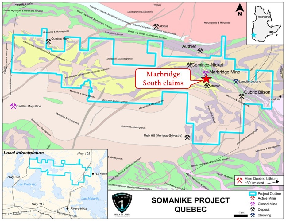
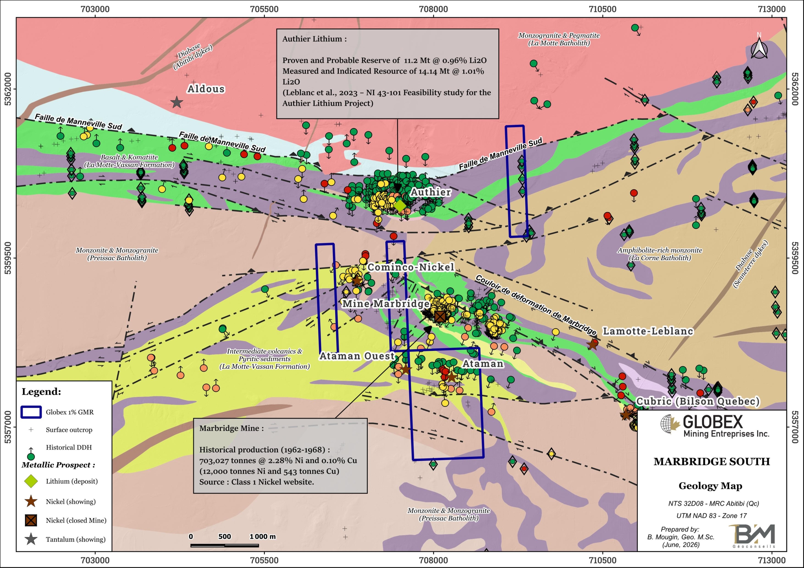
Rocks of the area were strongly deformed. The property is squeezed between the Manneville-Sud Fault to the north and the Rivière-Héva Deformation Corridor to the south. The Marbridge shear zone is also associated with several Ni (±Cu ±EGP) prospects, including the Marbridge former mine (historical production of 703,027 tonnes grading 2.28% Ni for a total of 12,000 tonnes Ni and 543 tonnes Cu). The La Motte Anticline (Imreh, 1984) is an overturned fold inclined to the south. Regional metamorphism generally exhibits a green schist facies and can reach an amphibolite facies near late-tectonic intrusions.
The Marbridge South property is mostly underlain by volcanic rocks of the Lamotte-Vassan Formation (LVF), and intermediate intrusive rocks of the Preissac batholith. The LVF consists largely of komatiites with lesser intercalated basalts and minor felsic volcanoclastites and undifferentiated metasediments. This largely ultramafic sequence is intruded by three major batholiths (ET84-03; RG160; MM82-04) : the La Motte, Preissac and Lacorne Batholiths, respectively of monzogranitic, granitic and granodioritic compositions. The LVF and granitoid plutons are crosscut by Proterozoic diabase dykes.
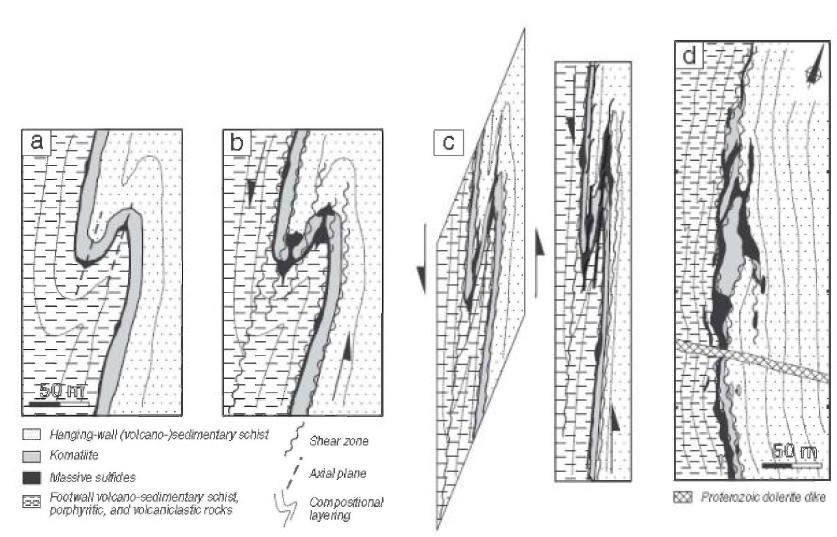
The area of the Marbridge South property hosts several occurrences of nickel mineralization associated with komatiites (Kambalda-type mineralization). This type of deposit is mainly emplaced at the base of the komatiitic flow due to the difference in density between the denser sulfide liquid and the less dense silicate liquid (Huppert and Sparks, 1985; Lesher et al., 1984). Deformation causes a change in the geometry of the deposit. Massive sulfides tend to remobilize and concentrate in fold hinges and shear zones, while mineralized lenses use to boudinate along the fold flanks (MB2015-12).
The Marbridge mine is located about 500 meters from the property. Falconbridge Nickel reported production of 702,366 tons grading 2.28% Ni and 0.10% Cu from 1962 to 1968 (Class 1 Nickel website) from four mineralized lenses, prior to being placed on care and maintenance in 1968. Mineralization is commonly found in komatiite and it is associated with a shear zone or massive sulfide veins. The lithologies are affected by tight folding with a NW-SE structural grain. Near mineralized zones, ultramafic rocks show serpentine, talc and tremolite-actinote alteration. The Marbridge Shear Corridor extends to the NW on Globex’s royalty claims.
The Authier Lithium deposit of Sayona Mining Ltd. is located about 500 meters north from the Marbridge South property, within mafic and ultramafic volcanics of the La Motte-Vassan Formation, south of the La Motte Batholith. JORC compliant Proven and Probable Reserves of 11.2 Mt @ 0.96 % Li2O have been calculated on the Authier Lithium Project in 2023 (Leblanc et al., NI 43-101 Feasibility Study Report).
The Moly Hill deposit is located about 2.7 km south of the Marbridge South property. The “Moly Hill Pluton” consists of muscovite-garnet monzogranite and biotite monzogranite. Molybdenite and bismuth mineralization lies at the contact between the ultramafic rocks and the muscovite-garnet monzogranite. Work carried out by Moly Hill Mining Corporation between 1965 and 1966 led to a historical resource estimation (non-43-101 compliant) of 272,400 short tons @ 0.13% Mo (0.21% MoS2) and 0.079% Bi (DPV 619). The molybdenite mineralization is contained within three (3) different pegmatitic quartz veins with muscovite and potassium feldspar, associated with NNE-trending shear zones hosted both in intrusive rocks and UM volcanics. To the southwest lies a biotite monzogranite containing several aplite and granitic pegmatite dykes in which disseminated beryl and columbite-tantalite mineralization is present (Boily, 1995).
History
Following the discovery of Ni mineralization in La Motte township in 1957, Falconbridge started extensive exploration programs which led to the Marbridge Mine production in 1962. From 1962 to 1968, 702,366t of ore grading 2.28. Ni and 0.10% Cu have been extracted from Marbridge by Falconbridge.
No exploration work is available in public data from the period 1969-1991. In the 1990s, Falconbridge have shown renewed interest in this sector and carried out new geophysics and DDH, as well as environmental cleanup of the mining concession site.
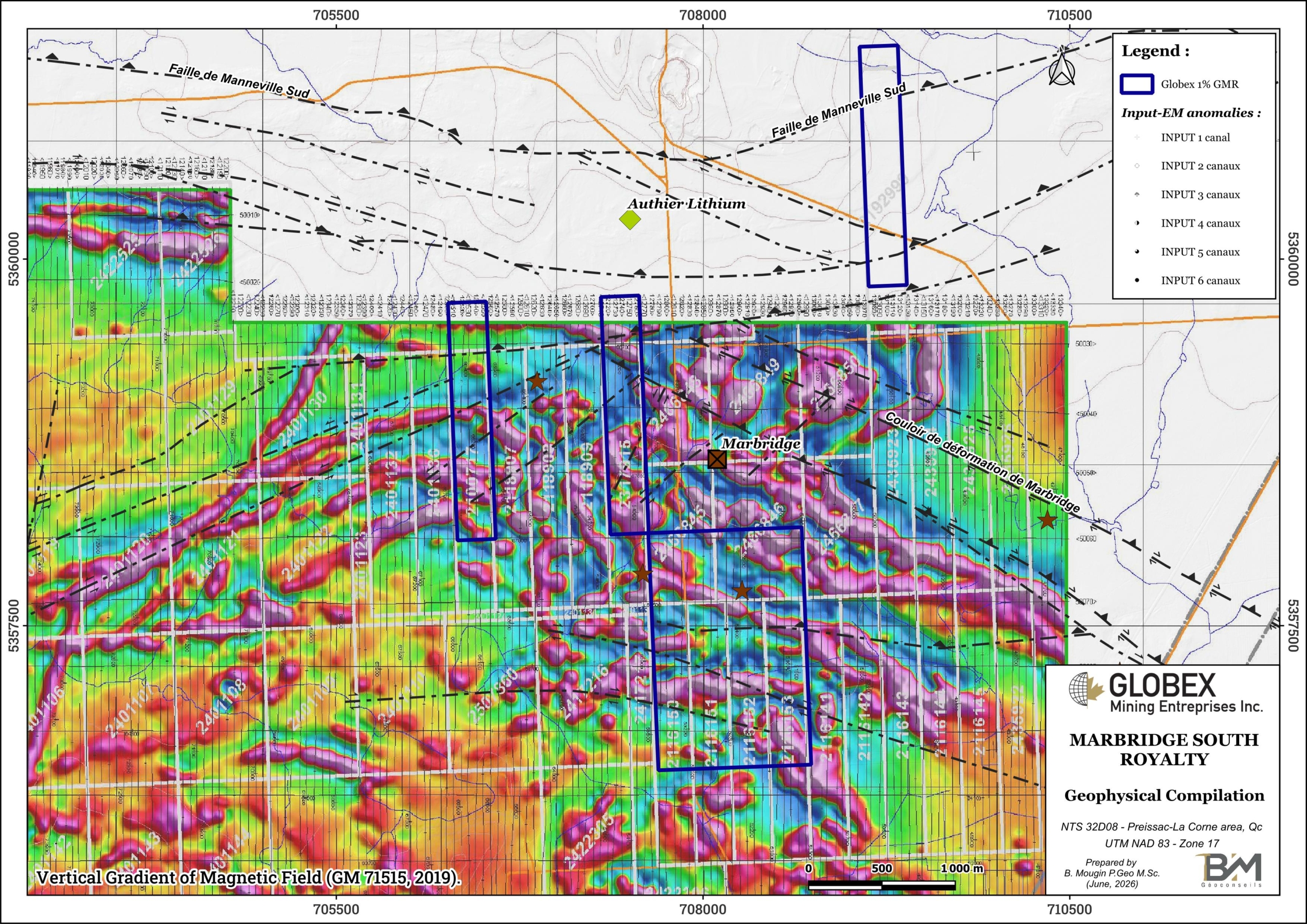
During the 2010s, Royal Nickel t carried out BEEP-MAT prospection, additional geophysics and more DDH. In 2015, Sphinx Resource bought the Marbridge South claims from Globex in exchange for the issuance of Sphinx shares to Globex and the addition of a royalty. The company completed the geophysical coverage of the property with a high resolution heliborne magnetic survey in 2019 (GM 71515), and implanted more than 1,000 meters of DDH as a follow-up on the best geophysical anomalies.
Recent work and developments :
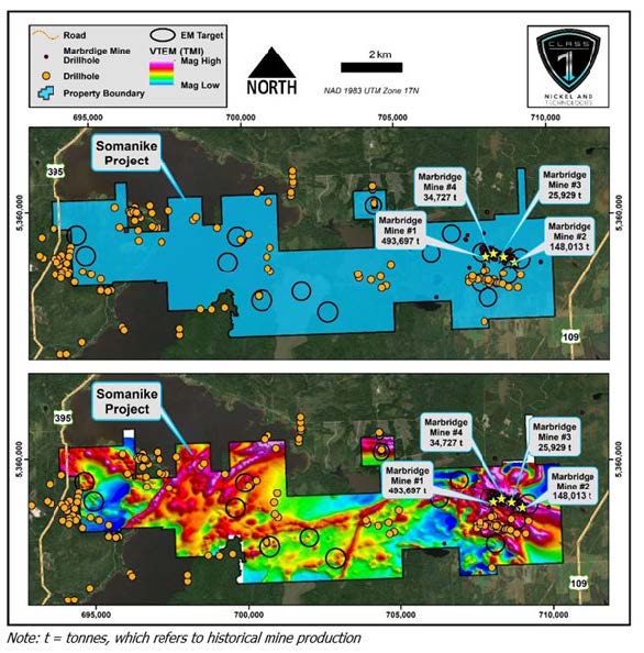
Class 1 Nickel acquired the Somanike project in 2020 and immediately started extensive geophysical and DDH programs (GM 73688). On February 8, 2023, Class 1 Nickel announced the completion of 40 drill holes (16,510m) at Somanike. Diamond drilling has intersected sulphide mineralization in 23 drill holes. Mineralization is within and, in close proximity to ultramafic rocks. The host rocks are komatiitic flows and can be correlated with the horizons in the mine sequences at Mine 1, Mine 2, Mine 3 and Mine 4. Drilling has confirmed that Mine 1 is in a separate stratigraphic/structural sequence from Mine 2, Mine 3 and Mine 4 that are in the hanging wall to Mine 1. Down hole time domain (BHEM) geophysical surveys on holes drilled to date have identified multiple off-hole anomalies for follow-up.
Drone mag and LIDAR surveys have been completed over the main Marbridge area. These have identified magnetic trends that demonstrate both definition of known nickel-bearing ultramafic rocks and the significant continuation of ultramafic rocks into under-explored areas.
Resources and Potential
Class 1 Nickel is currently exploring the Marbridge South Property as part of its Somanike Nickel-Copper Project, a large property which also includes the former Marbridge Mine. The Company’s primary objective is to make a major discovery of high-grade magmatic nickel sulphides in an environment of known nickel mineralization with significant opportunity for new discoveries.
Multiple geophysical exploration targets exist within the Somanike Project, including in the Marbridge South property area.
Effective depth of exploration from the previous drilling is limited to the top 200 m in the areas explored outside the vicinity of Marbridge #1 Mine, which remains very superficial and encourages further in-depth discoveries in this area.