
McNeely
Location, Access, Description
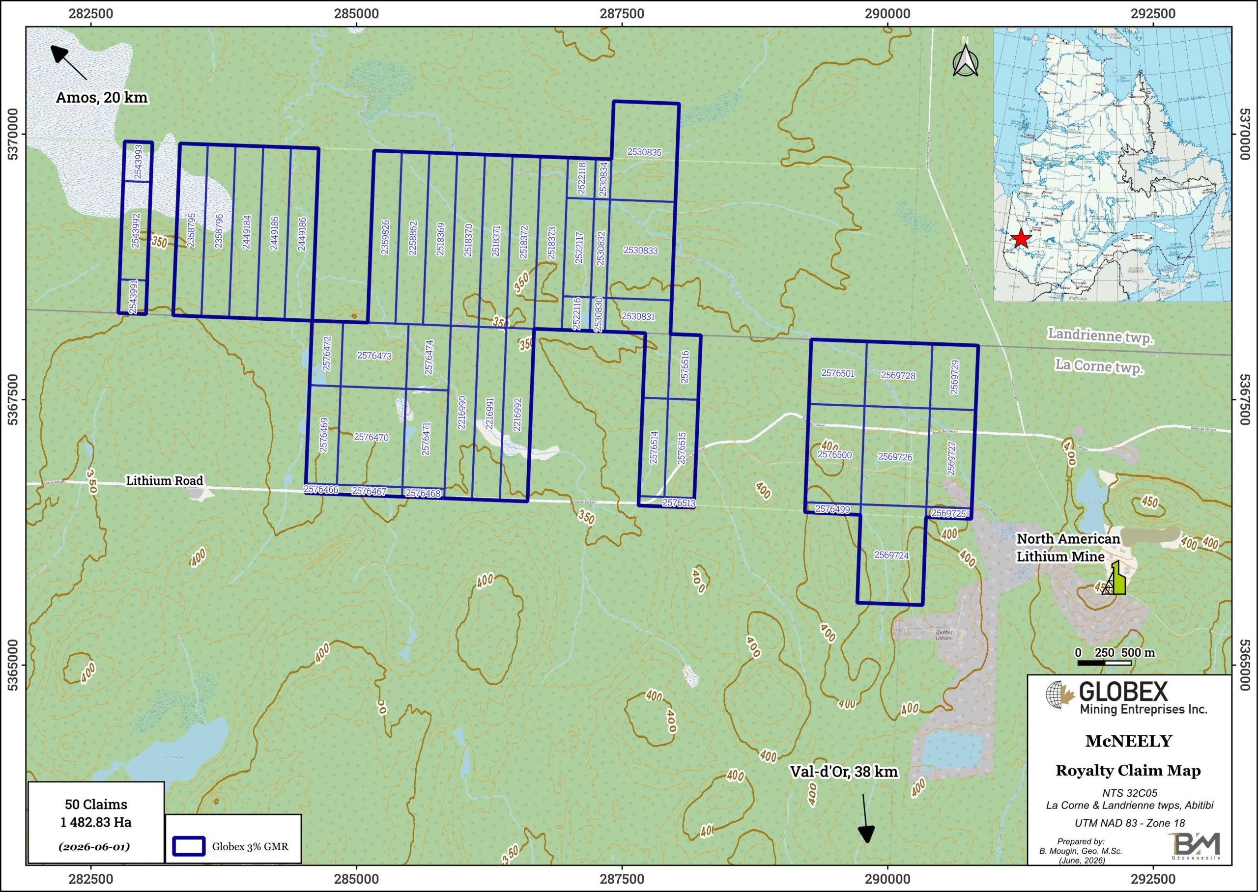
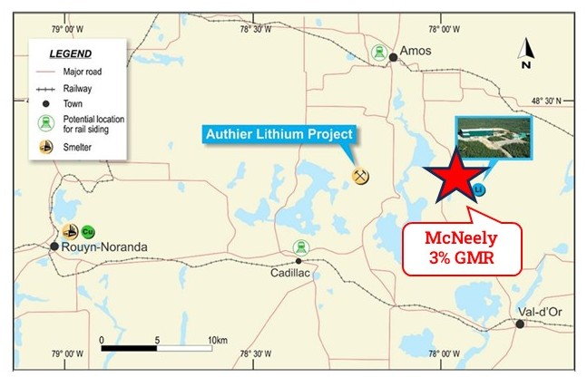
The McNeely property consists of 50 mining claims covering an area of 1 482.83 Ha in La Corne and Landrienne townships, northwestern Quebec, approximately 22 km SE of Amos (Qc) and 38 km NNW of Val-d’Or (Qc).
The claims are located less than 2 km west of the North American Lithium Project of Sayona Quebec Inc. The North American Lithium deposit hosts Proven and Probable Reserve of 21.7 Mt @ 1.08% Li2O, and Measured and Indicated Resource of 25 Mt @ 1.23% Li2O (Leblanc et al., 2023 – NI 43-101 Feasibility study for the NAL Project). The McNeely property has been sold to Linear Minerals Corp. (ex First Energy Metals) in 2021, and Globex will retain a 3% Gross Metal Royalty (GMR) on any future production on these 50 specific claims.
The property is centred in a well- developed mining region with many resource industry support facilities and services. The towns of Rouyn-Noranda, Val-d’Or and Amos have populations of between 25,000 and 60,000 and are well known for their mining history. The project is readily accessible by national highway and a high-quality rural road network.
Geology and Mineralization
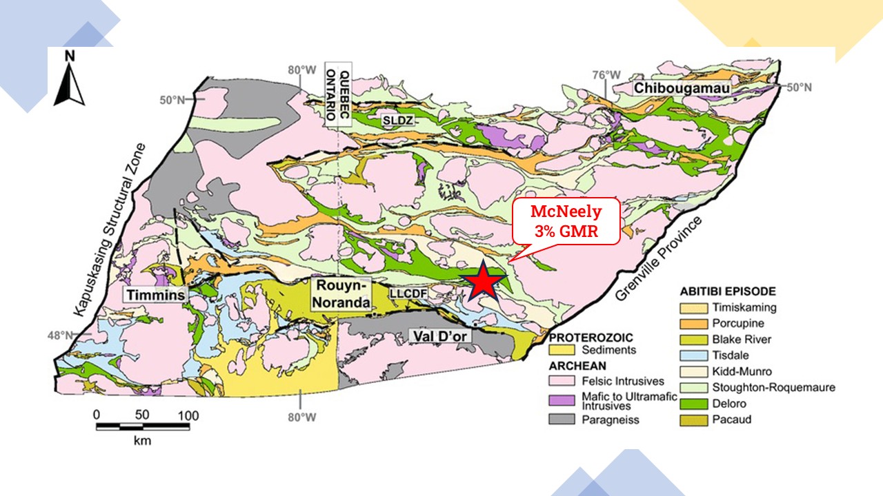
The Archean Preissac-La Corne batholith is a syn- to post-tectonic intrusion that was emplaced in the Southern Volcanic Zone of the Abitibi Greenstone Belt of the Superior Province of Québec. The batholith intruded along the La Pause anticline into the ultramafic to mafic lavas of the Kinojevis (2,718 Ma; Corfu 1993) and Malartic groups, and biotite schist of the Kewagama Group. The batholith is bounded to the north by the Manneville fault and to the south by the Cadillac fault and the eastward extension of the Porcupine-Destor fault.
The Preissac-La Corne batholith is a composite body comprising early metaluminous gabbro, diorite, monzonite and granodiorite (ca. 2,650-2,760 Ma: Steiger and Wasserburg 1969, Feng and Kerrich 1991) and four late peraluminous monzogranitic plutons (Preissac, Moly Hill, La Motte and La Corne) and associated pegmatites and quartz veins (ca. 2,621-2,655 Ma: Gariépy and Allègre 1985, Feng and Kerrich 1991). The final intrusive activity in the area was the Proterozoic diabase dykes. The regional metamorphic grade is greenschist facies and close to the batholith is hornblende hornfels facies contact metamorphism.
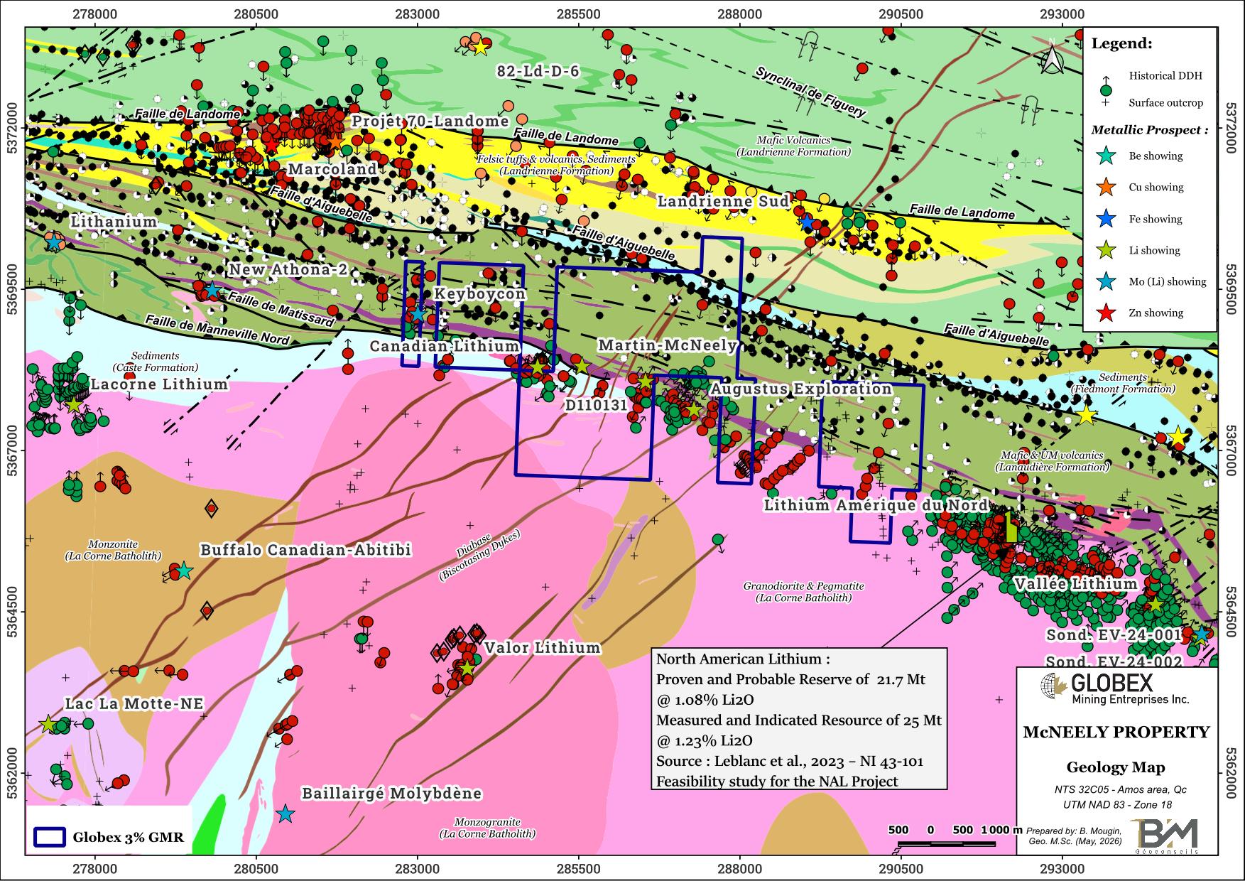
The McNeely property is settled onto the regional contact zone between mafic and ultramafic (UM) volcanic rocks of the Kinojévis Group and felsic intrusions of the La Corne Batholith. The western part of the property is crossed in ESE orientation by the Manneville-Nord fault which brings the volcanic rocks of the Lanaudière Formation, to the north, into contact with the sediments of the Caste Formation, to the south. Volcanic and sedimentary rocks on the property are characterized by a strong deformation and penetrative foliation with a WNW-ESE general trend. The La Corne Batholith is composed predominantly of intrusive calc-alkaline metaluminous foliated rocks whose composition varies from diorite to granodiorite; the La Corne Batholith also includes a halo of pegmatites mineralized in Li, Be, Ta, and Mo.
In the Preissac-La Corne region, there are many pegmatites and aplites that seem to have been formed within fractures, joints, and dykes. Historical exploration work has identified numerous lithium-bearing dykes in the area of the property. The Li mineralization consists of spodumene and lepidolite crystals (±Mo, ±Be, ±Ta) within sodium pegmatites associated with fracturing of the La Corne Batholith. The pegmatites are located on either side of the batholith’s contact zone and are generally oriented parallel to it. The prospective dykes are usually pegmatitic, and composed of albitic plagioclase and k-feldspar (25 to 40%), quartz (30 to 40%), spodumene (5 to 20%), muscovite (0 to 5%) and a series of accessory minerals including beryl, garnet, columbo-tantalite, lepidolite, molybdenite and bismuthinite. The width of the dykes and irregular masses varies from 5 cm to 40 meters with lateral extensions reaching over 500 meters.
It should also be noted that molybdenite mineralization is not confined to pegmatites but rather limited to so-called hydrothermal veins formed by quartz, K-feldspars, muscovite and molybdenite located inside but on the edge of muscovite-bearing monzogranite facies with ±garnet from Preissac, La Motte and Moly Hill plutons.
The reference deposit of the area is the North American Lithium deposit which is located about 2 km east of the property, on which a positive feasibility study was released by Sayona Quebec in 2023.
The Mc Neely property hosts two mineral prospects ; the Martin-McNeely Li showing was discovered in 1955 in diamond drilling by Martin-McNeely Mines : The M-3 drill hole intersected 1.09% Li₂O over 2.44 m at a depth of approximately 90 m in a biotite-quartz-feldspar pegmatite containing up to 3% lepidolite (GM 03315-B). The Keyboycon Mo-Li showing hosts a molybdenum-lithium mineralization consisting of numerous small mineralized pegmatite dykes that cut through intermediate to mafic volcanic rocks of the Lanaudière Formation; hole 3 returned 0.3% MoS2 / 1.0m (GM 03632) and hole CAN11-12 returned 1.37% Li2O over 2.0m (GM 67154). In the southeastern part of McNeely property, several holes intersected a spodumene-bearing pegmatite dyke grading up to 0.48% Li2O / 6.46m including 0.99% Li2O / 2.74m (CL-30) (GM 03952).
History
Exploration for pegmatites in the Preissac-La Motte area began in the early 1900s; the presence of molybdenite was first reported in 1901 (RG 160). The primary focus was initially on molybdenum. In 1942, the discovery of spodumene pegmatite at the site that would become the Québec Lithium Mine sparked interest in lithium. Exploration for lithium increased with the development of the Québec Lithium Mine in the 1950s and declined with the mine’s closure in 1965, partly due to falling prices and a declining market for the metal (GM 65011). In 1957, the discovery of the nickel deposit at the Marbridge Mine, which was mined from 1962 to 1967, sparked a boom in nickel (RG 160). In the early 2000s, interest in lithium increased.
Past exploration work on the McNeely property took place primarily from the early 1950s to the mid-1980s. Various mapping and grab sampling campaigns, trenching and rock stripping, geophysical surveys, and diamond drilling have identified numerous granitic pegmatite dikes containing spodumene (±molybdenum, ±tantalum, ±beryllium). Detailed information about exploration history are given in the 2021 Globex’s compilation report on the McNeely property.
Recent work and developments :
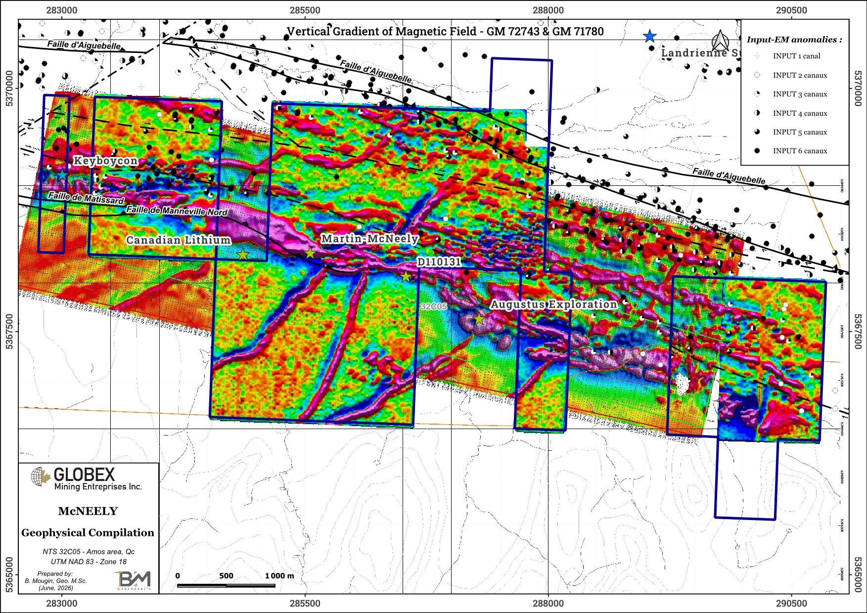
In 2017 and 2019, Globex carried out geological mapping and grab sampling on the McNeely property (GM 70384, GM 71537). Anomalies up to 0.38% Li2O returned from spodumene-bearing pegmatites in the central part of the property. In 2020, Globex conducted a high resolution airborne magnetic survey on the entire McNeely property (GM 71780). In 2021, Globex conducted a historical work compilation report on the McNeely property which demonstrated that the property hosts several narrow spodumene-bearing pegmatites often hidden below thin overburden (GM 71934). The author recommended to conduct a high definition radiometry survey in order to highlight unknown and eventually larger mineralized pegmatites.
Globex sold the property to First Energy Metals Ltd. (now Linear Minerals Inc.) in June, 2021. Between 2021 and 2023, First Energy has undertaken high resolution helicopter-borne magnetic survey over the Augustus Lithium property (GM 72743), followed by an extensive drilling program with 18 drill holes (3,207.84 meters) located on Globex’s McNeely royalty claims (GM 72276 and GM 73569).
Between 2022 and 2025, Consolidated Lithium Metals (ex Jourdan Resources) undertook soil sampling and tree biogeochemical sampling programs directly west of the McNeely property (GM 74485, GM 74656). Beloborodov wrote that “the lithium Li grade in the Preissac-Lacorne area shows significant variation and can range from being undetectable by the laboratory to registering measurable levels, with average grade 36.39 ppm Li and maximum value of 243 ppm Li.” This represents the most recent work listed in public data for the property.
Resources and Potential
Although the regional metallogenic zone is clearly identified here, the main challenge for exploration in this area comes from the limited number of outcrops, coupled with the fact that the mineralization we are seeking has no specific geophysical signature. The prospecting campaigns conducted by Globex in 2017 and 2019 demonstrated that lithium-bearing pegmatites could be detected beneath a thin layer of overburden by surface prospection using a portable radiometer.
The high-definition magnetic survey conducted by Globex in 2020 provides an exceptional level of detail. Low-magnetic bands oriented parallel to the regional stratigraphy within mafic and ultramafic volcanic rocks, can be interpreted as alteration zones or possible pegmatite dykes. A gravity survey would help refine priority targets for the search for new pegmatites, while a resistivity survey would help identify areas favorable for rock stripping.