
Montalembert
Location, Access, Description
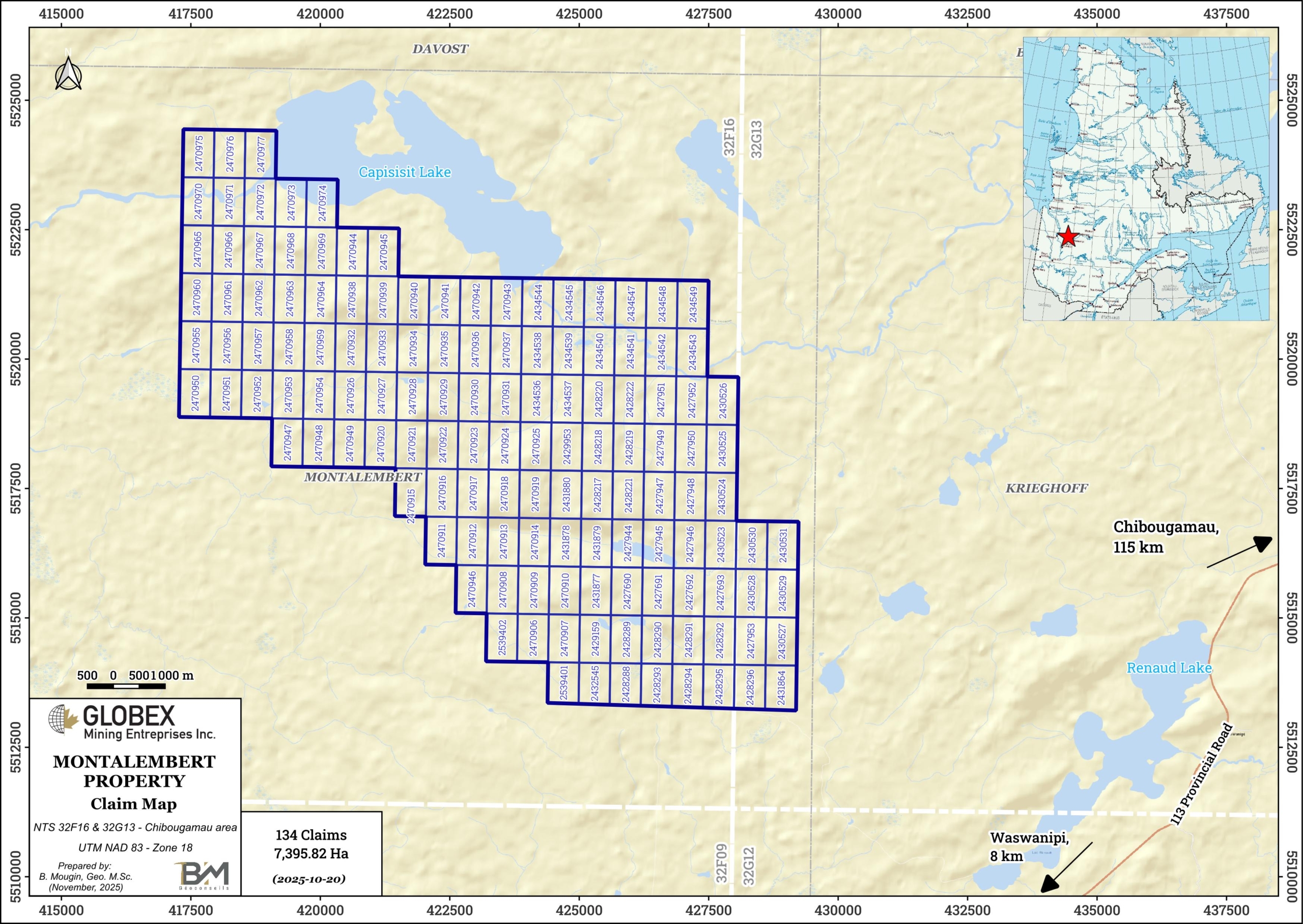
The Montalembert property is located in the Eeyou-Istchee James Bay Territory of northern Quebec, about 8 km west of the Waswanipi Cree Community (Qc) and 85 km southwest of Chibougamau (Qc). It is composed of 134 mining titles covering 223.22 Ha located on the north shore of Wachigabau Lake. The claims are located on Category II Territory where mineral exploration activities are allowed under specific conditions.Globex is 100% owner of the property which is not subject to any third-party interests. The property is easily accessible by road from Waswanipi (Qc), driving on a network of gravel roads.
Geology and Mineralization
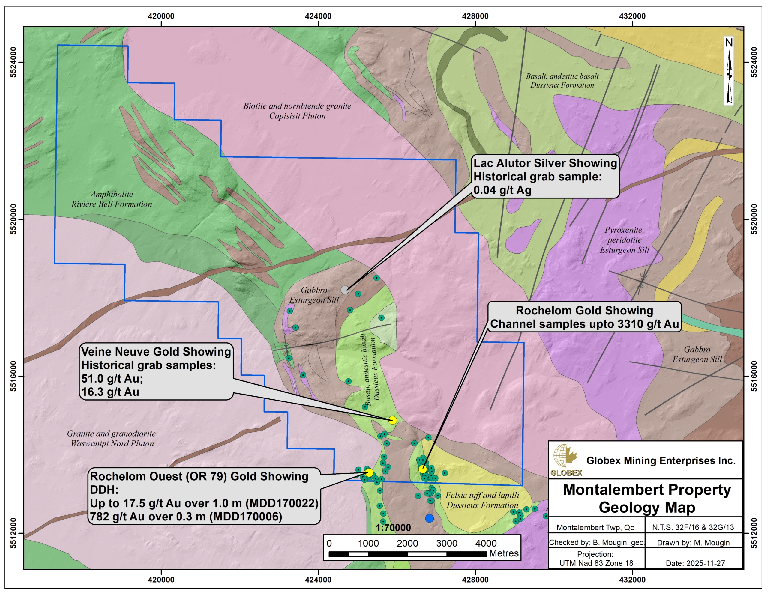
The Montalembert property is located within the Northern Volcanic Zone (NVZ) of the Abitibi sub-province of the Superior province of the Canadian Shield which consists predominantly of Archean volcanics, sedimentary and intrusive rocks, and Proterozoic diabase dikes (Chown et al., 1992). The Montalembert property is situated near the western limit of the Chibougamau-Chapais greenstone belt in the NE end of the Abitibi sub-province, close to its contact with the Opatica sub-province.
The area was mapped by Quebec Ministry’s geologists in 1984 (Sharma and Lauzière, 1984 – ET84-02; Hébert, 1984 – ET84-07). The Montalembert property is squeezed between the Waswanipi-Nord Pluton and the Capisisit Pluton. Regional foliation in the volcano-sedimentary sequence is molded by the regional intrusions; north of the property, formations strike ENE with a dip to the NNW, becoming almost N-S with a steep dip to the east in the south part of the property (Daoudene et al., 2014 – MB2014-04).
Geology of the Montalembert property is composed of mafic volcanics (Obatogamau, Rivière Bell and Dussieux Formations) and minor felsic tufs (Dussieux Formation), intruded by concordant and discordant mafic and ultramafic sills (Sturgeon Complex), as well as large granitic masses. The Waswanipi-Nord Pluton and the Capisisit plutons have strongly deformed and metamorphosed the encasing rocks.
The systematic rock sampling conducted across the property by Globex in 2015 shows the property is cut by a network of faults with orientations varying from WNW, NNE, NE and ENE. The general regional metamorphism is greenschist facies, except in the vicinity of intrusive bodies, where it can go to the amphibolite facies.
Metallogeny
The south part of the property hosts a couple of historic gold showings. The most significant ones include the Galena veins, vein No. 2, Rabbit veins and vein No. 3. Gold mineralization in these areas associates with silicified shear hosted quartz veins containing 1-10% pyrite and/or pyrrhotite, with minor amount of chalcopyrite and galena and occasional molybdenum. Visible gold is very common in this area of the property.
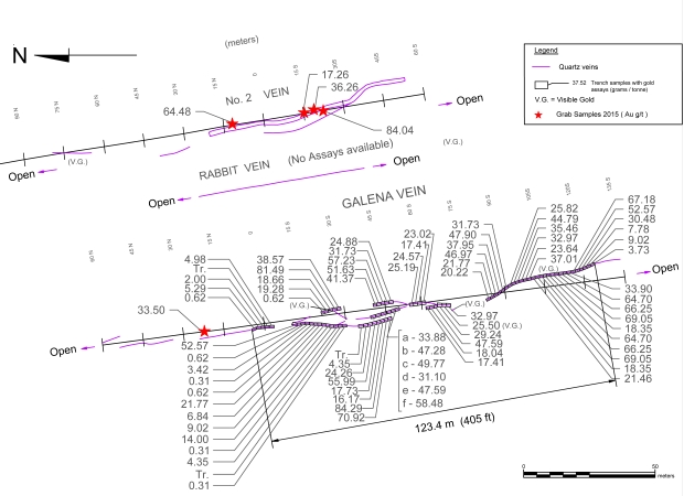
These veins have been stripped extensively by both Globex and Enforcer in the course of recent exploration work. The exposed part of Galena vein is in excess of 200 m along strike with an average width of 3m. The No. 2 vein is exposed over a length of 175 m along strike with an average width of 6m. Excavations made 150m north of the main veins show these structures continue extensively along strike. Surface exploration work by Enforcer Gold Corp in 2017 also returned 3 310 g/t Au over 1.0m in channel sampling (GM71208).
Extensive drilling by Enforcer in the area in 2017 consistently intersected the structures hosting gold mineralization, with erratic gold mineralization (GM71208). Assay results of drilling in OR79 zones shows a very good correlation between gold mineralization and sulphur content as well as copper, lead, silver and zinc.
The Capisisit Pluton was probably the heat source for remobilization of the quartz and gold in the shear zones in the area (Garant and Riopel, 2015).
History
Gold was discovered on the property in 1949 by N.A. Timmins. Prospecting followed by trenching and limited diamond drilling located four quartz veins (Galena, Number 1, Number 2 and Rabbit veins) of varying widths up to 1.5m and with strike lengths of 90m to 365m, within multiple north-south shears observed along a corridor 1 280 m long and 183m wide.
Sampling of the Galena quartz vein returned 17.2 gpt Au over a 61m sample length and an average width of 0.75m. Gold was reported as coarse free gold principally within the quartz veins but also within the enclosing rocks. A drill hole located 105m to the southwest of the trenched area returned values of up to 61.3 gpt Au over a true width of 1.2m and 19 gpt Au over 0.6m.
In 1973, a grubstake syndicate stripped and cleared the Galena, Rabbit and Number 2 veins. The property was then acquired by Rochelom Mines Ltd., which undertook a detailed trenching and analysis of the Galena vein system over a near continuous strike length of 123m, an average sample width of 0.65m and to a depth of 0.6m. Seventy eight samples collected from fine blast material over continuous 1.5m lengths and two 2.3m lengths weighing approximately 3.6 kg each were reported to have returned an average of 20.8 gpt Au (28.9 gpt Au uncut).
Rejects from the 80 samples were combined into seven samples weighing 345 kg, bagged and sent to the Quebec government assay lab as an outside check due to the high grade nature of the mineralization. The government assay lab average for the combined sample assays returned 18.4 gpt Au, confirming previous samples.
Subsequently, a five ton bulk sample of vein material representing different lengths along the Galena quartz vein was grouped into bags with each lot being weighed, crushed, ground and split. The calculated average of the bulk samples gave 11.5 gpt Au over a sample length of 108 m and average width of 0.65 m.
Based upon the assay results, a decline was proposed to follow and sample the Galena vein for a length of 170 m along with a 78 m cross cut to the Number 2 vein to be followed by 210 m of additional drifting north and south along the Number 2 vein. It was noted that the cross cut would intersect the Rabbit vein affording additional sampling of this structure. The decline was never started and there is no record of additional work on the gold zones since the trench sampling in 1973, some 42 years ago. Although 210 m of drifting was proposed along Number 2 vein, there is no record of surface assays from this vein although a report references free gold.
Recent developments :
In 2015 the claims were available, and Globex staked 58 cells forming the eastern half of the Montalembert property. From July to November of that year, Globex conducted geological reconnaissance, line cutting, a Mag survey, systematic mapping and sampling, and trench stripping and sampling, south of the Vieux Lacs area (GM69300). From the Galena vein, the best result was 4.66 g/t gold. From the No.2 vein, the four best results ranged from 17.26 g/t Au to 64.48 g/t Au.
In 2016, a further 72 cells were added to the property for a total of 132 cells for a total of 7,293.06 hectares, and Globex returned to the property to continue exploration, and proceeded to wash out, map and sample the Galena, No. 2 and cross-trenches.
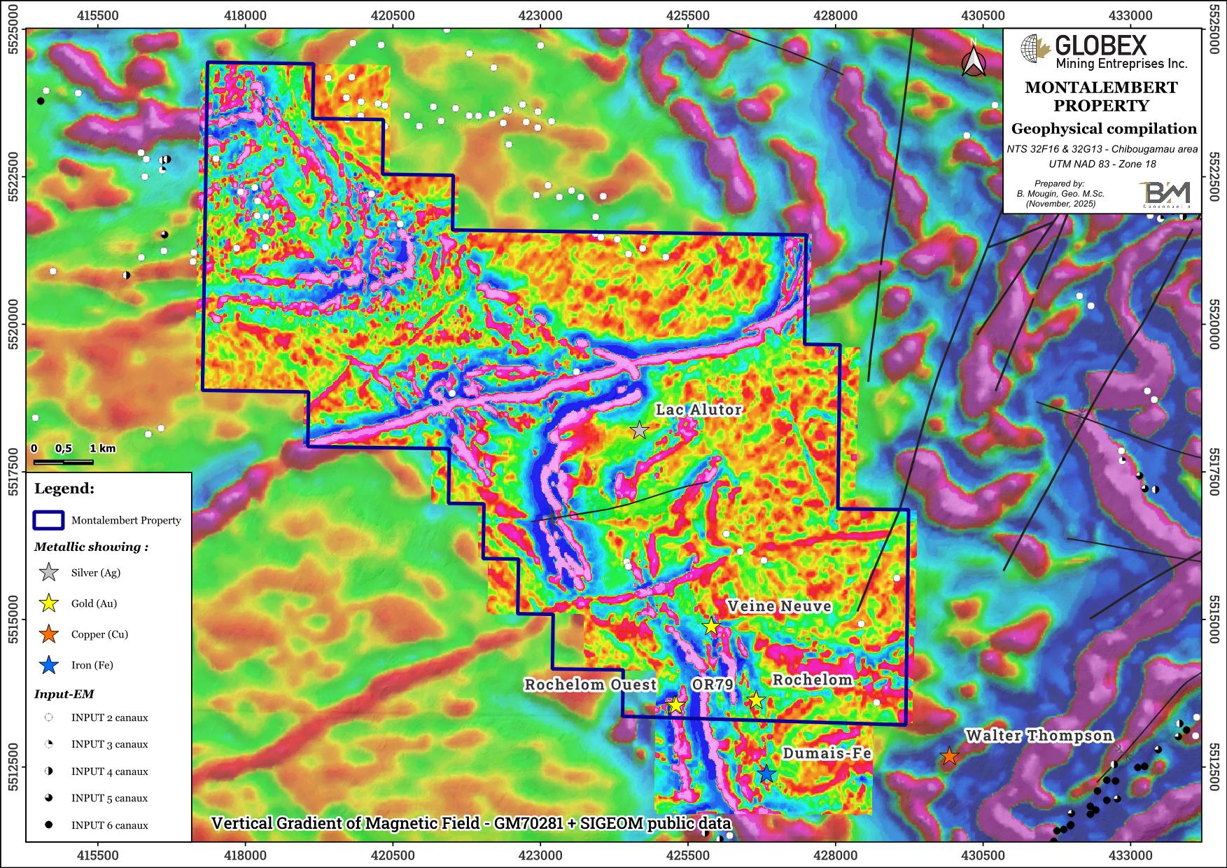
In 2017-2018, Enforcer Gold Corp (Enforcer) carried out extensive exploration work on the Montalembert property. High resolution helicopter-borne magnetic gradiometer and VLF-EM survey was flown in 2017 (GM70281), followed the same year by grab sampling, trenching, channel-sampling, and diamond-drilling. A 5,784.4 meters DDH program of 45 drillholes led to the discovery of a new gold mineralized zone, now called OR79, where anomalous gold values were recorded from assaying of grab and channel samples collected from shear-hosted North-South trending narrow and parallel quartz veins in association with significant sulphide mineralization (GM71208). Assays up to 17.5 g/t Au over 1.0m and 782 g/t Au over 0.3m were intersected in DDH.
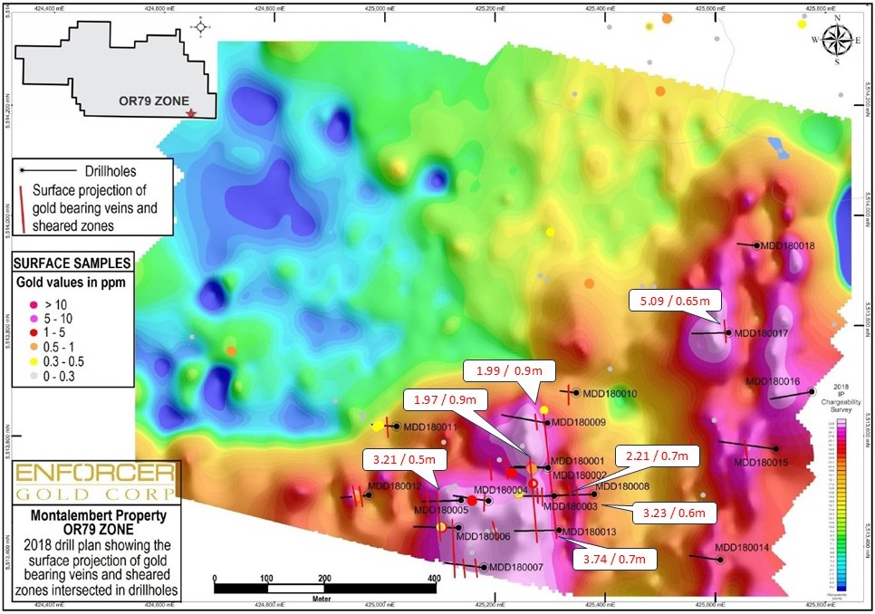
Considering the nature of the geology and the mineralization style of the area, a 22.8 line-km induced polarization (IP) survey was designed in the southern part of the property in 2018 (GM71239) to map the sulphide rich zone, define the extent and orientation of the quartz veins and map lithologic contacts within the area. A total of 1 750m of drilling was also completed in 18 drillholes to test the anomalous surface samples and the anomalies defined by the IP survey at depth (GM71141). Assays up to 5.09 g/t Au over 0.65m were intersected on the OR79 area. A 3D model of the drillholes shows that the auriferous veins/sheared zones are continuous downdip and along strike.

Resources and Potential
No resource has been estimated yet on the Montalembert property.
Properties with occurrences of coarse free gold are particularly difficult to explore. While gold may be present in significant quantities, it is difficult to assess the quantity or grade by traditional grab sampling, channel-sampling or core sampling. Large volume (bulk) sampling such as that undertaken by Rochelom Mines Ltd. in 1973 is required.
Drilling on the Montalembert property was essentially focused on the south area, so that a large part of the property remains untested below surface. The deepest vertical depth of the holes drilled by Enforcer in 2017 and 2018 in the main mineralized zone is about 87 m from the surface. It is therefore recommended that deeper holes be drilled in the area. It is also recommended that the rest of the property be covered with new ground IP surveys in order to highlight new anomalous areas and to define new DDH targets.