
Preissac Moly
Location, Access, Description
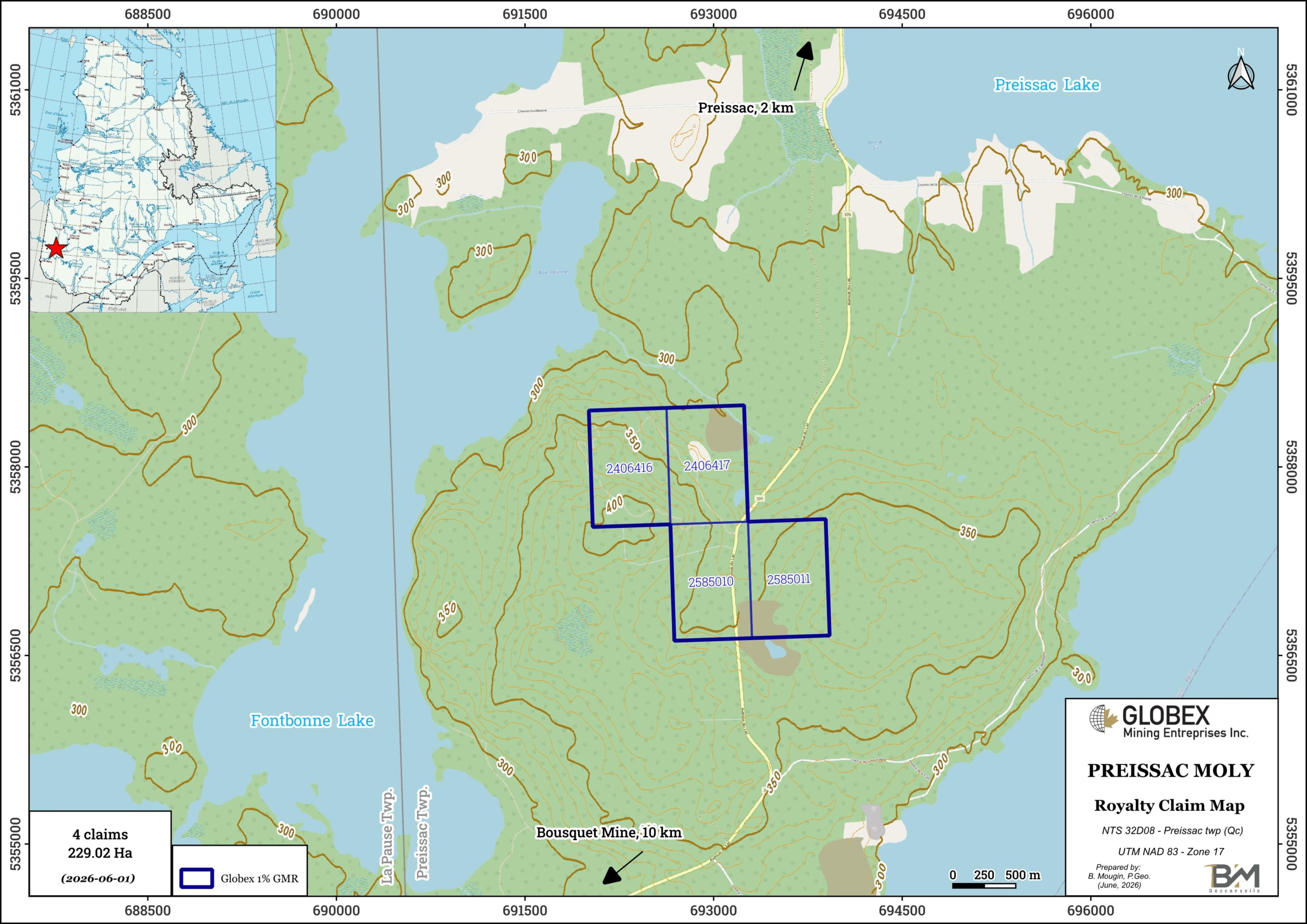
The Preissac Moly property consists of 4 mining claims covering an area of 229.02 Ha in the Preissac Township of Abitibi-Temiscamingue (Quebec). The claims are located approximately 30 km southwest of Amos (Qc) and 50 km west of Val-d’Or (Qc). The claims belong to Linear Minerals (ex First Energy Metals), and Globex will retain a 1% Gross Metal Royalty (GMR) on any future production.
The property is accessible in vehicle driving on the 395 paved Road linking Val-d’Or to Preissac and a network of gravel roads and exploration trails. The towns of Amos and Val-d’Or can provide remote workers with all food and sleep facilities as well as shops and contractors.
Geology and Mineralization
The information below was transcribed from D’Amours, 2009 (GM64514) and Lafrance et al., 2015 (MB2015-12).
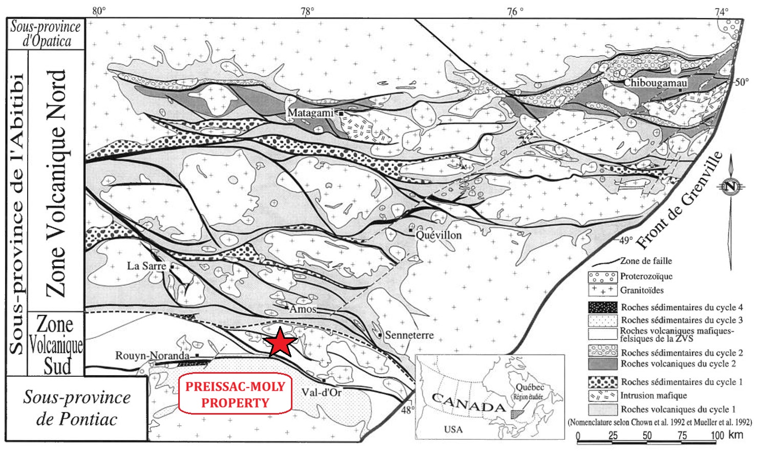
The Moly Hill property is located within the Abitibi Subprovince of the Canadian Shield. The Abitibi Subprovince is an Archean greenstone belt which hosts some of the richest mineral deposits of the Superior Province.; it is divided into two distinct parts (Chown et al., 1992): the South Volcanic Zone (SVZ) and the North Volcanic Zone (NVZ), separated by the Destor-Porcupine-Manneville fault.
The property lies at the stratigraphic base of the Malartic Group (Dimroth et al., 1982) which extends from just north of the town of Val D’Or up to the Destor-Porcupine Tectonic Zone. The Malartic Group consists of a volcano-sedimentary assemblage characterised by the predominance of komatiitic and tholeiitic lava flows. It is divided in three formations which are from bottom to top: (1) the Lamotte-Vassan Formation, (2) the Dubuisson Formation, and (3) the Jacola Formation. This volcano-sedimentary assemblage is crosscut by pre to post-tectonic plutons and by NE-SW Proterozoic dykes.
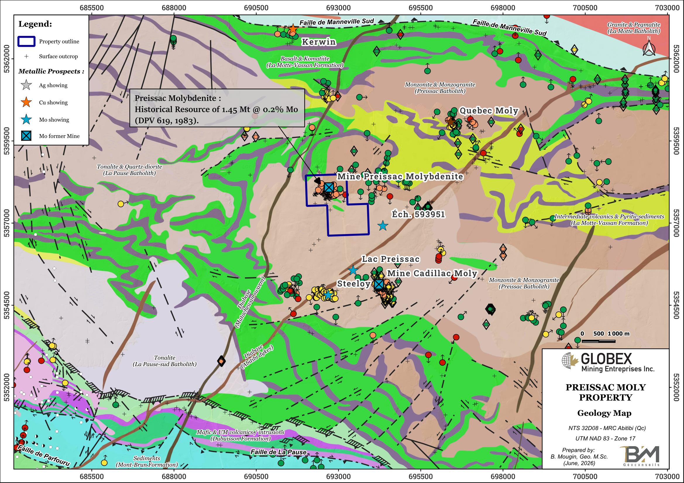
Rocks of the area were strongly deformed and present evidences of a moderately east-dipping stretching lineation. The property is squeezed between the Manneville-Sud Fault to the north and the Rivière-Héva Deformation Corridor to the south. The Marbridge shear zone is also associated with several Ni (±Cu ±EGP) prospects, including the Marbridge former mine (historical production of 703,027 tonnes grading 2.28% Ni for a total of 12,000 tonnes Ni and 543 tonnes Cu). The La Motte Anticline (Imreh, 1984) is an overturned fold inclined to the south. Regional metamorphism generally exhibits a green schist facies and can reach an amphibolite facies near late-tectonic intrusions.
The Preissac Moly property is underlain by intermediate intrusive rocks of the Preissac batholith and volcanics of the Lamotte-Vassan Formation (LVF). The LVF consists largely of komatiites with lesser intercalated basalts and minor felsic volcanoclastites and undifferentiated metasediments. This largely ultramafic sequence is intruded by three major batholiths (ET84-03; RG160; MM82-04) : the La Motte, Preissac and Lacorne Batholiths, respectively of monzogranitic, granitic and granodioritic compositions. The LVF and granitoid plutons are crosscut by Proterozoic diabase dykes.
The Preissac-Moly property is home to the former Preissac Molybdenite Mine, where molybdenum and bismuth mineralization is confined within pegmatites, pegmatitic quartz veins, and gray to white quartz veins. These veins occupy tension fractures resulting from the emplacement of the Preissac batholith, located near the northern margin of the granitic massif.
The mine’s mineralized zone forms a 600 m x 3.40 m corridor oriented N337°/40°. The mineralization, which occurs primarily in pegmatitic quartz veins, consists of molybdenite, pyrite, chalcopyrite, bismuthinite, native bismuth, and tantalite in disseminated form. Molybdenite occurs as sheets or in characteristic rosettes, and bismuthinite forms automorphic needles or clusters of oxidized sulfides. Purple fluorite is locally recorded within the quartz veins. Other accessory minerals include galena, hematite, ilmenite, magnetite, pyrrhotite, rutile, sphalerite, and nickel-bearing minerals (GM 26924).
The Marbridge mine is located about 15 km east of the Preissac Moly Property. Falconbridge Nickel reported production of 702,366 tons grading 2.28% Ni and 0.10% Cu from 1962 to 1968 (Class 1 Nickel website) from four mineralized mineralized lenses, prior to being placed on care and maintenance in 1968. Mineralization is commonly found in komatiite and it is associated with a shear zone or massive sulfide veins. The lithologies are affected by tight folding with a NW-SE structural grain. Near mineralized zones, ultramafic rocks show serpentine, talc and tremolite-actinote alteration.
The Authier Lithium deposit of Sayona Mining Ltd. is located about 15 km ENE from the Preissac Moly Property, within mafic and ultramafic volcanics of the La Motte-Vassan Formation, south of the La Motte Batholith. JORC compliant Proven and Probable Reserves of 11.2 Mt @ 0.96 % Li2O have been calculated on the Authier Lithium Project in 2023 (Leblanc et al., NI 43-101 Feasibility Study Report).
History
Molybdenum was first discovered in the Preissac area in 1901.
In 1943, a government agreement between the Government of Canada and Indian Molybdenum Ltd. led to the start of production at the Preissac Molybdenite Mine. Between 1943 and 1944, this mine was operated at the -125-foot (-38 m) level via a inclined shaft and a network of 1,650-foot (503 m) of tunnels, and produced 91,489 tons of ore grading 0.42% MoS2. The contract between the two parties was terminated on April 30, 1944, and production ceased even though the reserves had not been fully depleted (GM 25320).
The mine resumed production from 1962 to 1971. In 1971, Preissac Molybdenite Mines Ltd. went bankrupt and the mine was closed. A total of, 2,236,000 tons grading 0.186% Mo and 0.03% Bi were extracted from the ground during the two production periods (DV 85-08). Remaining historical resource of 1.45 Mt @ 0.2% Mo were estimated in 1983 (DPV 619).
Noranda Exploration Ltd. acquired the Preissac Molybdenite property and conducted bulk sampling of 4,200 tons of rock from a trench located approximately 450 meters northwest of the mine (Jarvi, 1977). The results indicate that molybdenum and bismuth concentrations are higher in the eastern part of the trench, near the contact between the Preissac batholith and the shales of the La Motte-Vassan Formation. The report concluded that the system remains open to both the north and the south.
According to public data, a total of 44 DDH (7,086 m) have been drilled on the Preissac Moly by previous detentors, essentially in 1956-1957.
The public MEGATEM II survey conducted in 2008 on NTS 32D08 covers only the northern portion of that sheet and does not extend onto the property at all.
Recent work and developments :
In 2016, Globex conducted field work in order to reexamine Noranda’s trenches and to prospect for new mineralized veins. The molybdenum and bismuth anomalies reported from the 2016 sampling campaign are on the same order as the grades historically reported. Sampling also revealed the presence of a copper anomaly associated with a pyrite-bearing quartz vein in the La Motte-Vassan schists. Since this vein is associated with strong pyrite mineralization as well as some magnetite, it should show up clearly in induced polarization or magnetic surveys.
In 2021, Globex carried out historical work compilation following its acquisition of 2 additional claims (GM 72273).
Resources and Potential
Historical exploration on the Preissac-Moly property recognized sub-economic Mo mineralization associated with quartz veins hosted in NW-oriented shear zones. Based on historical drilling data, the potential for increasing resources appears to be limited.