Rivière Opinaca
Location, Access, Description
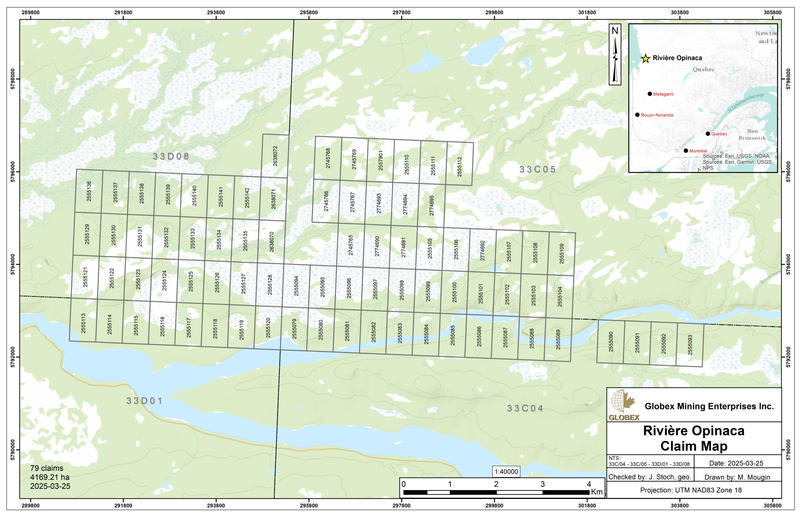
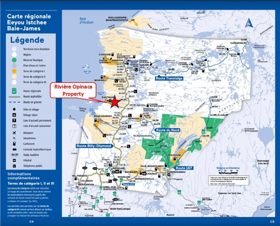
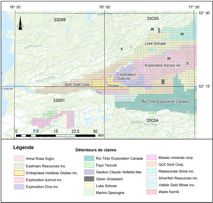
The Rivière Opinaca property consists of 79 claims covering an area of 4,169.21 Ha in Eeyou-Istchee James Bay Territory, approximately 30 km east of the Eastmain Native Community, Quebec. The claims are wholly owned by Globex Mining Enterprises Inc. and are located on Category II lands where exploration is allowed under conditions due to the fact that the Cree Nation holds exclusive hunting and fishing rights. The claims are not subject to any third-party agreements or royalties.
There is no access by road to the property since the Eastmain paved Road strikes about 10 km south of the property, south of the Opinaca River. The Eastmain and Opinaca rivers both contain numerous rapids and major waterfalls that restrict navigation. Access is therefore by helicopter either from Eastmain River Airport located about 30 km west of the property or from the KM 381 truck stop located about 55 km east of the property.
Workers involved in the project can stay and eat at the KM 381 truck stop. A hydro power line strikes approximately ESE about 15 km south of the property.
Geology and Mineralization
Regional Settings
The Rivière Opinaca property lies in the Superior Province of the Canadian Shield. In Quebec, the Superior Province can be divided into two main sectors. The southern sector is characterized by a succession of linear Subprovinces of metasedimentary (Pontiac, Nemiscau and Opinaca), volcano-plutonic (Abitibi, Opatica and La Grande) and metamorphic (Ashuanipi) composition, characterized by a regional E-W-trending structural grain.
The Superior Province is largely composed of Neoarchean rocks (2.8 to 2.5 Ga), but also includes significant Mesoarchean and Paleoarchean domains (3.6 to 2.8 Ga ; Tomlinson et al., 2004 ; MB 2006-03 ; Percival et al., 2012). Recent synthesis of the Superior Province by Percival et al. (2012) suggests that it would be the result of collisional and accretionary events between 2,720 Ma and 2,680 Ma, involving some protocontinental terranes showing evidence of evolution older than 2.8 Ga, and a cratonization process between 2680 and 2600 Ma.
The property is located in the Eastmain Domain of the La Grande Subprovince, near the northern boundary of the Nemiscau Subprovince. This large domain is composed of intrusions and gneisses (80%), submarine volcanics of mafic to intermediate composition, felsic volcanics, clastic sedimentary rocks and iron formation (Goutier, 2025).The La Grande Subprovince represents a volcanic-plutonic complex comprising Archean tonalitic basement (3.36 to 2.79 Ga), and the volcano-sedimentary bands of the La Grande River and the Lower Eastmain River (RG 2001-13 ; MB 97-30 ; MB 96-04 ; MM 94-01). These bands are characterized by the presence of ancient volcanic rocks (2,880 to 2,820 Ma) and younger volcano-sedimentary sequences (2,732 Ma). They are intruded by synvolcanic, syntectonic and late-tectonic intrusions of felsic to ultramafic composition.
Property Geology
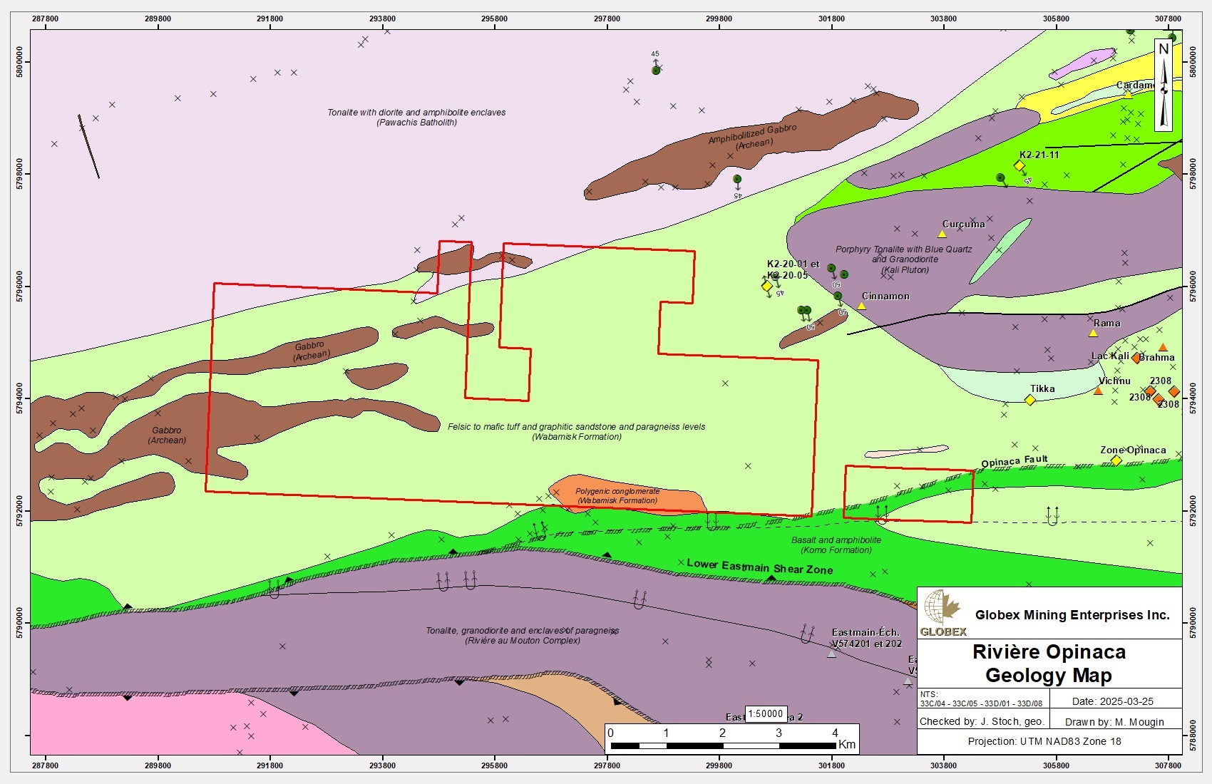
The Rivière Opinaca property belongs to the Medium and Lower-Eastmain Greenstone Belt (MLEGB). According to Sigéom, rocks of the property are mainly composed of felsic to mafic pyroclastic tuffs and graphitic shales of the Wabamisk Formation (RG 2002-09). This unit is composed of lapillis tuff, block tuff, ash tuff and crystal tuff in lesser proportions. These tuffs are fine- to medium-grained and mainly intermediate in composition, although they may be felsic or mafic (RG 2000-04, GM63970). However geological mapping and grab sampling by Globex in 2022 (Goutier, 2025) revealed that most of the property is actually composed of fine-grained tonalite.
Polygenic conglomerates of the Wabamisk Formation are mapped in the southern part of the property. All clasts are highly deformed and stretched, implying that the tonalitic clasts probably originate from a synvolcanic pluton (RG 2000-04).
Rocks of the Wabamisk Formation are intruded by Archean gabbro sills. Amphibolitized basalts of the Komo Formation are also mapped directly south of the property.
The main structural feature of the area is the Lower-Eastmain Shear Zone, located directly south of the property. Metamorphism is at the upper greenschists to upper amphibolitic grade.
Paleoproterozoic diabase dykes cut through the rocks of the region. They belong to either the Matachewan Dyke Swarm (N-S), the Lac Esprit Dykes (NW-SE) or the Senneterre Dykes (NE-SW).
Metallogeny
Regional Metallogeny
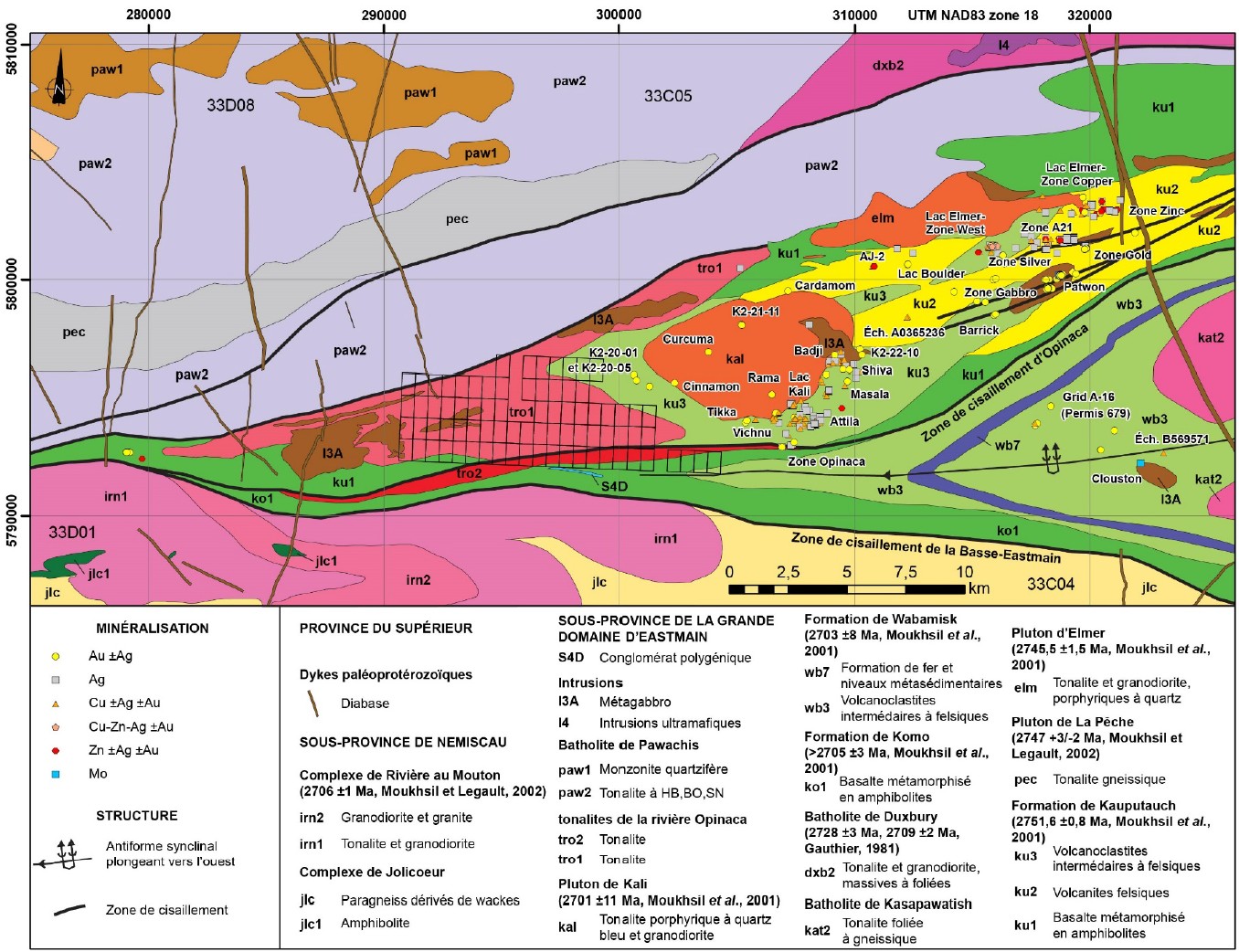
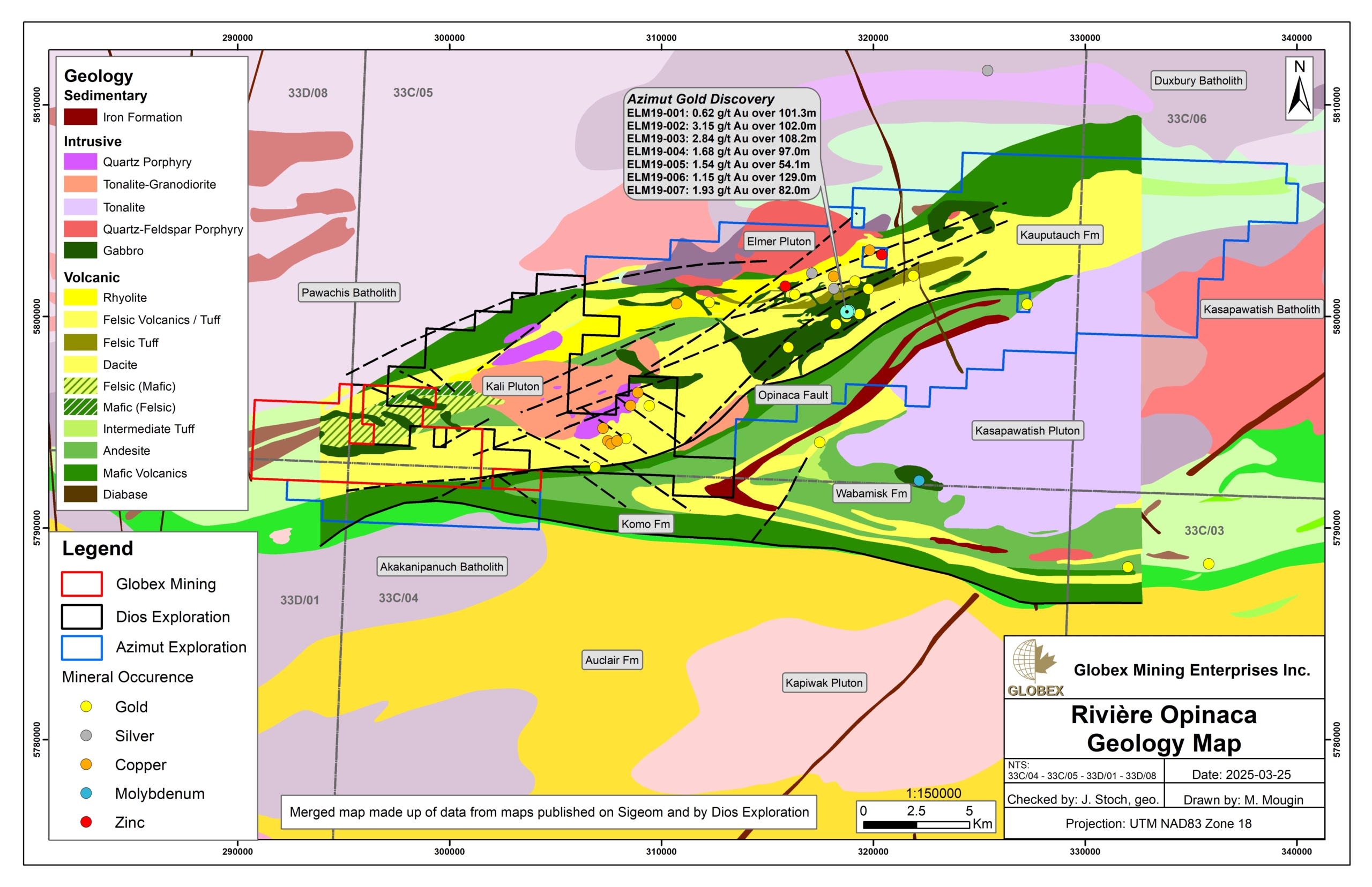
The region is known for its base and precious metal mineralization. They are mainly located north of the Opinaca Fault and structurally above the Kali and Elmer plutons. About forty metal showings hosting either Au, Ag, Cu and Zn, or different combinations of these metals, are listed in the Sigeom. Mineralization occurs as vein systems hosting disseminated quartz and sulfides, as well as disseminated or semi-massive sulfides in altered bands. The most common alterations are 1) a quartz-carbonate-chlorite assemblage; 2) a quartz-carbonate-chlorite-sericite assemblage; 3) a sericite-staurotide-garnet-andalousite-biotite-chlorite ± cordierite assemblage. This indicates the presence of both regional pre- and post-metamorphic systems.
Silver (Ag) mineralization is the most abundant. Grades range from 5 to 387 ppm Ag. They can occur alone or in association with gold, copper, zinc and lead. There is some positive correlation between silver and copper (chalcopyrite) grades across the region. Mineralization at Lake Kali occurs at the edge of the Kali Pluton and the beginning of the felsic volcanic pile (GM45406), while in the Attila showing area, mineralization is at a higher stratigraphic level, in the heart of felsic volcanics that are altered by a quartz-carbonate-chlorite assemblage (Dios Exploration website.
Gold (Au) mineralization can occur alone or in association with silver (Ag), copper (Cu), zinc (Zn) and sometimes lead (Pb). Grades range from 1,000 to 254,000 ppb. The most significant gold zone is Patwon, where one of the most striking drill holes returned an intersection of 102.5 m grading 3.15 g/t Au (GM72094). This zone has been delineated over a strike length of nearly 600 m, to a depth of 860 m and an average thickness of 35 m (Azimut Exploration website). It is hosted by volcanics affected by shear zones, carbonate-chlorite-sericite alteration and veins of quartz, pyrite and native gold. According to the press release of November 21, 2023, indicated mineral resources of 311,200 oz Au in 4.99 Mt grading 1.93 g/t Au have been estimated on the Patwon deposit.
Copper mineralization is generally associated with high silver and silver-gold grades. Grades range from 0.5 to 8.28% Cu. In the Kali Lake area, ±Ag, ±Au copper mineralization occurs in sheared, silicified and ankeritized corridors, containing disseminated sulfides (chalcopyrite and pyrite) in centimetric quartz veins (GM70622). A quartz-carbonate-chlorite alteration envelope is developed around the Attila showing (website of Dios Exploration).
Zinc mineralization is associated with high silver grades, locally with gold, and occasionally with lead. Grades range from 0.81 to 1.78% Pb. These mineralizations are mainly found at the Lac Elmer-Zone Zinc and Lac Elmer-West Zone showings. Mineralization occurs as massive sphalerite and pyrite veins and veinlets, with local galena, in felsic volcanics altered to sericite and, in part, biotite.
Property Mineralization
No metallic showing has been listed on the Rivière Opinaca Property yet. Grab sampling by Globex in 2025 returned only weak anomalies of 44 ppb Au and 1,1 ppm Ag (Goutier, 2025).
History
Not much historical work has been carried-out directly on the Rivière Opinaca Property. Information of the present section is essentially taken from Globex’s compilation and grab sampling report of the Rivière Opinaca property by Goutier (2025).
Previous geological work in the Rivière Opinaca area is very limited. The first geological observations were made by Low (1896) during a canoe survey, from 1892 to 1895, along the Eastmain River and in a large area of Quebec and Labrador. Low noted the presence of the following rocks : gabbro, diorite, amphibolite, pyrite-bearing schist, diabase, deformed granite, mica-bearing dioritic gneiss, micaceous schist, conglomerate and quartz veins with pyrite and chalcopyrite. His assays revealed only traces of gold.
The first mining exploration work was carried out in 1935 and 1936 for Dome Mines in the James Bay region (GM09863-A). This work consisted of prospecting along the Eastmain River, stripping, diamond drilling and aerial reconnaissance of the area. Gold-bearing quartz-tourmaline-sulfide veins were discovered, with the best grade being 6.00 dwts (penny weight) over 3 ft (10.3 g/t over 0.9 m) in hole no. 3. This area is now submerged beneath the Paix des Braves reservoir (33B04).
Eade (1966) and Franconi (DP-329; DPV-574) carried out detailed geological mapping. The property area consists of undifferentiated volcanodetritic rocks, metabasalt south of the Opinaca River, feldspathic and quartz porphyries and gabbro dykes. No mineralized showings were reported in this area at the time.
In the 1970s-1980s, the Société de développement de la Baie James (SDBJ) and Canico focused on prospecting, geophysics and geochemical sampling over a large area, leading to the discovery of the first copper, silver and gold mineralized showings in the Kali Lake area (GM37994; GM38169). Mineralization takes the form of 1) sheared and silicified zones with pyrite and chalcopyrite in quartz porphyry; 2) quartz-carbonate veins with disseminated amphibole, pyrite and chalcopyrite; 3) fractures plated with malachite and chalcopyrite; 4) tuff or rhyolitic flows with disseminated pyrite.
In the 1990s, exploration was concentrated to the NE of the property, in the Kali Lake and Elmer Lake areas and consisted in geological mapping, geophysics and drilling. This work led to the discovery of the Patwon gold showing.
Geological mapping at 1:50,000 scale was carried out by Moukhsil (RG 2001-08) and Moukhsil et al. (RG 2002-09). It covered outcrops on the property. Subsequently, a geological and metallogenic synthesis of the southern part of the Eastmain Domain was carried out by Moukhsil et al. (ET 2002-06). They also interpret the mineralization in the Elmer Lake area as epithermal in origin, and that at Kali Lake as magmatic porphyry.
In the 2000s and 2010s, the Quebec Government conducted mineral potential assessments for the porphyry Cu-Au ±Mo deposits and orogenic gold of James Bay (EP 2008-01; EP 2009-01; EP 2015-01). These studies covered the eastern part of the property and confirmed the strong mineral potential of this area. The Quebec government also commissioned a high-resolution survey in this part of the Eastmain River (DP 2011-03).
In 2010 and 2020, Dios Exploration explored their K2 property south of Kali Lake and found several gold, silver and copper showings (GM71679; GM73616). IOS Services Géoscientifiques has carried out a detailed compilation of exploration work in the Kali Lake area for Augyva Mining Resources (GM67833) which identified a new gold occurrence.
In 2018, Azimut Exploration carried out a series of trenching, sampling and drilling programs (GM72094; GM73394; GM73395), as well as geophysical surveys on the Elmer property. The most significant result came from drilling over 102.5 m grading 3.15 g/t Au, including 10.1 g/t Au over 20.5 m on the Patwon Au-Ag-Te Zone (Azimut Exploration website). The initial mineral resource estimate for this zone is 311,200 ounces in 4.99 Mt grading 1.93 g/t Au (Indicated Resources) and 513,900 ounces in 8.22 Mt grading 1.94 g/t Au (Inferred Resources), according to the press release dated November 21, 2023.
In the 2020s, QcX Gold has commissioned a lithological sampling campaign, a very high-resolution helicopter-borne survey on the western part of the Golden Giant project (GM72035), an induced polarization survey (GM72095) and a drilling campaign (GM73281). Anomalous gold values up to 1.435 g/t Au over 0.8 m were obtained from drilling on the western block. Midland Exploration undertook rock and soil sampling on its Komo property (GM73538), which led to the discovery of a copper showing (0.9% Cu).
Globex Mining Enterprises has commissioned a very high-resolution helicopter-borne magnetic survey on the Rivière Opinaca property (GM72394), as well as a mapping and prospecting campaign in 2022 (Goutier, 2025).
Resources and Potential
Numerous occurrences of both precious and base metals are listed in the property area. These mineralized zones are hosted in a ENE-oriented greenstone band located between the Lower-Eastmain Shear Zone to the south and the Duxbury and Pawachis Batholiths to the north.
It is curious that no metallic occurrence has ever been noted directly on the Rivière Opinaca property since this one is located in strike SW of the mineralized corridor. According to Goutier (2025), this is probably associated with the shift from volcanoclastites in the NE to tonalite in the SW of the region, as well as increasing distance from the Kali and Elmer plutons.
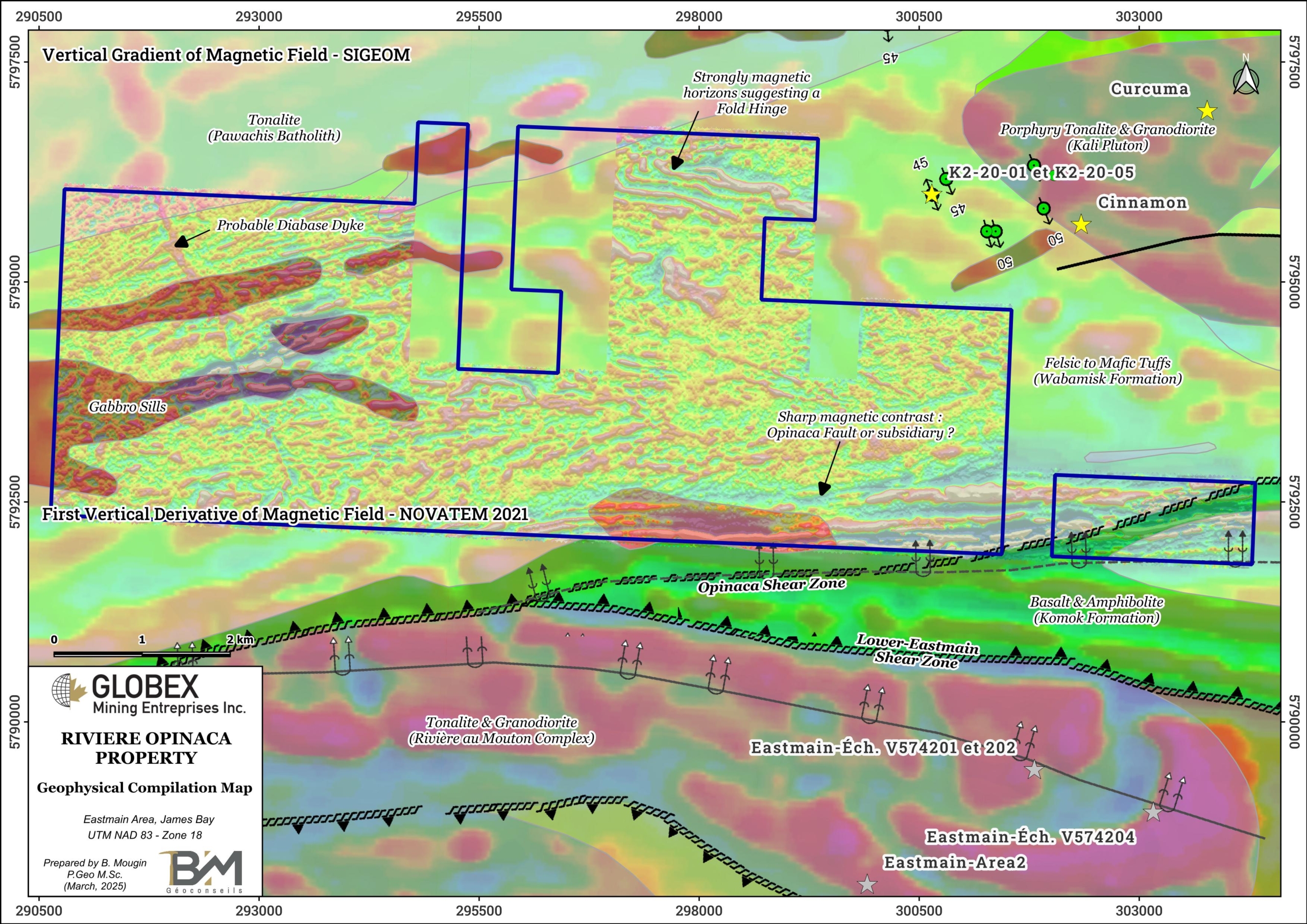
Further exploration of the property is therefore necessary. Detailed field mapping should verify some observations made on the 2021 NOVATEM survey data : 1) an unmapped diabase dyke appears to trend NNW in the western part of the property ; 2) magnetic horizons appear to outline a fold hinge in the northern part of the property ; 3) the Opinaca fault which marks the contact between the Wabamisk tuffs and the Komo basalts and amphibolites, appears to be located slightly further north than indicated on Sigéom, on the Globex claims. This would be an interesting asset since this fault is associated with the Zone Opinaca Au showing (up to 3.17 g/t Au, 23.9 g/t Ag and 349 ppm Zn on grab samples) about 2.7 km east of the property.
Future work should also consider Ground IP survey on targeted grids. A first grid should cover the sharp magnetic contrast (Opinaca Fault ?) identified on NOVATEM data in the SE part of the property. A second grid should cover the fold hinge identified on NOVATEM data in the north part of the property. Mechanical stripping should then be considered for any IP target highlighted.

