Shortt Lake Mine
Location, Access, Description
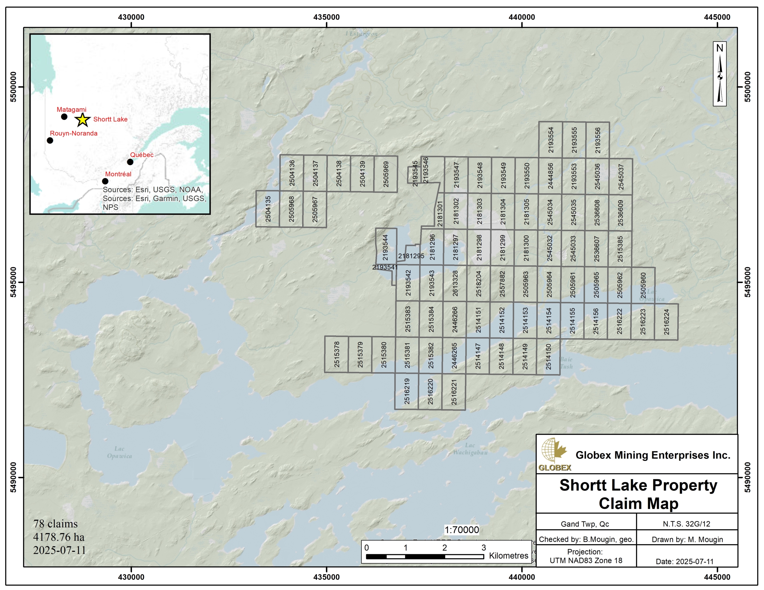
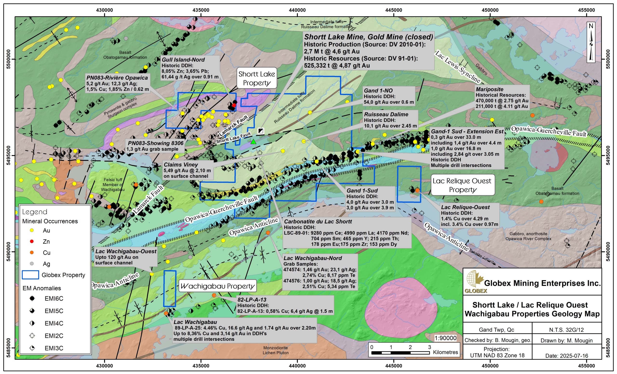
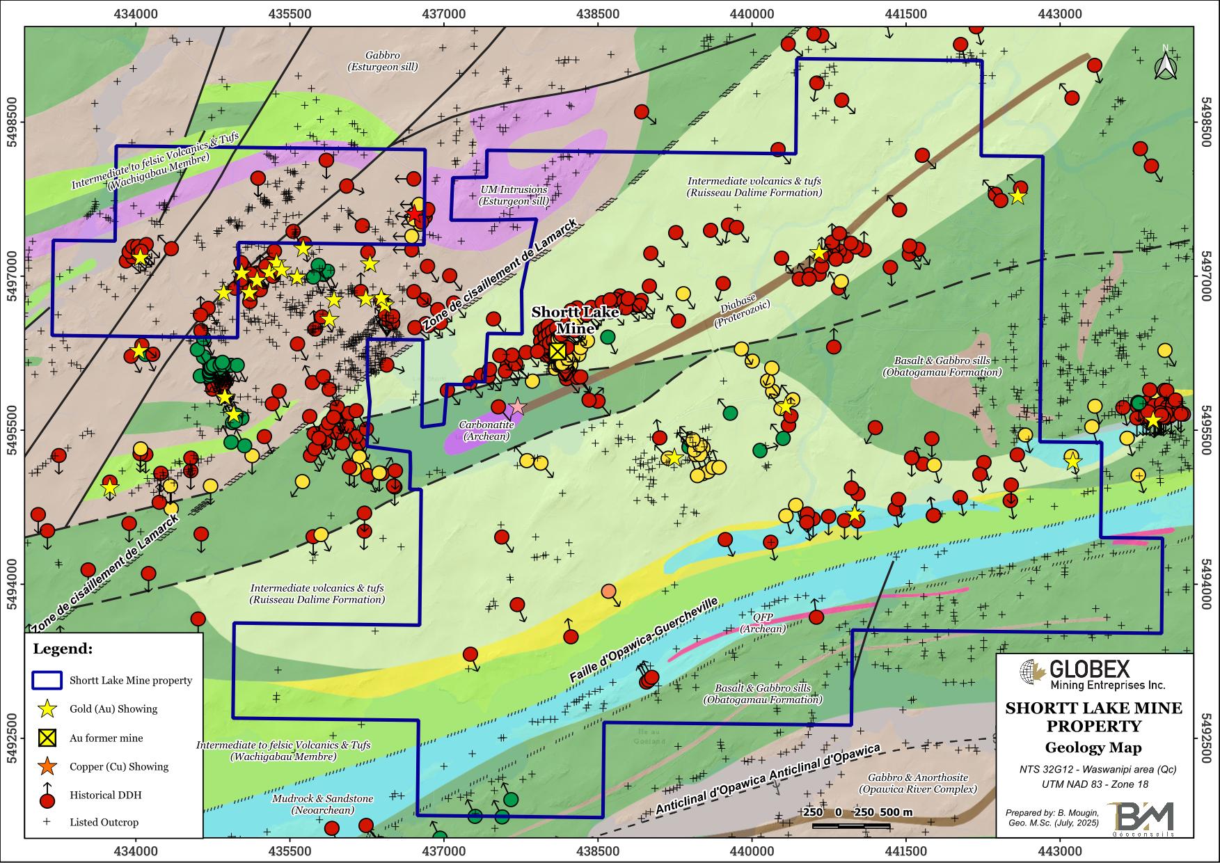
The Shortt Lake property is located in the Eeyou-Istchee James Bay Territory, Nord-Du-Quebec region, about 17 km south of the Waswanipi Cree Community (Qc) and 120 km southwest of Chibougamau (Qc). It is composed of 78 mining titles totalling 4,178.76 Ha, in Gand and Lesperance townships (NTS 32G12), on the north shore of Opawica Lake. Globex is 100% owner of the property which is not subject to any third-party interests.
The property is accessible by road from Lebel-sur-Quevillon (Qc), driving about 120 km north on Provincial Road 113. A gravel road leads to the Shortt Lake Mine about 12 km further southeast. Food and sleep accommodation, and gasoline can be found in Lebel-sur-Quevillon, Chapais or Chibougamau.
Geology and Mineralization
Regional Settings
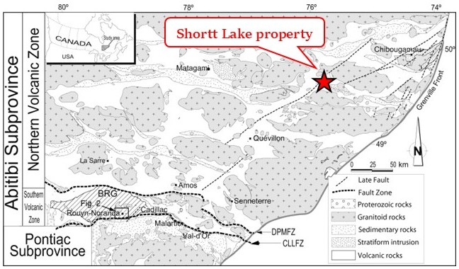
The Shortt Lake Mine property is located in the northeast part of the Abitibi Subprovince, an Archean Greenstone Belt which hosts some of the richest mineral deposits of the Superior Province. This area belongs to the Northern Volcanic Zone (NVZ) of Chown et al (1992) which exposes the eldest rocks of the Abitibi Sub-province (2,730 – 2,710 Ma).
The property is part of the southern band of the Chibougamau-Matagami belt, so called the Caopatina-Quévillon greenstone belt (MB 90-01). The region is structured by an alternance of anticlinal and synclinal structures. In the region of the property, the heart of the Opawica anticline is occupied by the Opawica Pluton, a synvolcanic tonalite. The Lewis Lake syncline is made up of intermediate to mafic volcanics of the Obatogamau, Wachigabau and Ruisseau Dalime Formations which are located at the very base of the 1st volcanic cycle of the Chapais-Chibougamau area (MM 89-03). These rocks are squeezed between two large intrusions : the Rachel pluton to the north, and the Lichen Pluton to the south. Regional foliation is moulded around these large plutonic masses.
Rocks from the Chibougamau-Matagami greenstone belt were deformed and metamorphosed by two orogens ; the earlier Kenorean orogen (2,800-2,600 Ma) resulted in large E-W domes & basins structures and associated E-W, SE and NE regional fault systems. The Grenville orogen (1,300-1,000 Ma), on the other hand is responsible for the NNE regional fault system. Two (2) regional shear zones affect the rocks of the area. A mylonitic band associated with the regional Opawica-Guercheville fault crosses the area in a E-W to ENE direction on more than 130 km. The Lamarck shear zone cuts the Opawica-Guercheville fault in a NE direction. NE-oriented Proterozoic diabase swarms cut all Archean units of the region.
The metamorphic grade of the Caopatina-Quévillon belt is of greenshist facies, locally reaching the amphibolites facies near the Grenville front and along major shear zones and intrusion margins.
Property Geology
The Shortt Lake Mine property is centered on felsic to mafic volcanics and tufs of the Wachigabau, Ruisseau Dalime and Obatogamau Formations which are among the oldest rocks of the Abitibi Subprovince. Foliation is E-W to ENE-oriented and metamorphism is at the greenschists grade.
The main lithostratigraphic units are the mafic and generally porphyritic lavas of the Obatogamau Formation, including the Wachigabau Member consisting of felsic lavas and pyroclastites. The Espoir, Cominco and Butte gold mineralized zones have been identified in the felsic volcanics of the Wachigabau Member. This unit is overlain by the Ruisseau Dalime Formation, which consists of sediments of volcanic origin that possibly mark the emergence of the volcanic center. It is moderately to strongly deformed and hosts a few gold-bearing mineralized zones, commonly vein-type cutting volcanic rocks. (Lamothe, 1981, 1982, 1987; Sharma, 1981; Sharma and Lauzière, 1983; Giovenazzo, 1983, 1986; Gautier, 1986; Barrette, 1989; Lauzière et al., 1989b; Doucet, 1993; Midra et al., 1993).
A small carbonatite plug is mapped under the Shortt lake in the central part of the property. A metasedimentary horizon is also present in the south part of the property along a collapse basin bordered on both sides by the Opawica-Guercheville fault. Narrow QFP dykes are also reported along this basin.
The NE-oriented Lamarck fault displaced all these units. West of the Lamarck fault, the property is composed of gabbro and ultramafic (UM) rocks of the Esturgeon sill.
The Opawica Pluton, located right southeast of the property, is a 500 m to 3.5 km wide intrusion lying in the heart of the Opawica River Complex. It’s composed of tonalite, quartz-diorite and QFP dykes (Midra, 1989). The Opawica River Complex is similar to the Doré Lake anorthositic Complex and consists of a banded intrusion with an anorthositic level at its base, surmounted by a 900 metres thick gabbro-ferropyroxenite level (Midra, 1989).
Regional Metallogeny
The mining district of Chapais-Chibougamau has for long been known as “the shear zone hosted deposits region” and produced approximately 1.2M tons of copper, 3.7M oz of gold, 20.9M oz of silver, 115 000 kg of zinc and 4000 kg of lead (MB-96-14). The region is host to several types of deposits and showings within a wide variety of geological context. The Caopatica Segment is host of the principal gold producing mine in the district, the Joe Mann mine. It is also host of two past producing gold deposits (Lac Shortt and Lac Bachelor mines), and of one past producing Zn-Pb-Ag deposit, the Coniagas mine.
Following Brochu & Hamel-Hébert (BG 2023-06), deposit types in the area of the Shortt Lake Mine property is essentially composed of orogenic Gold associated to the Guercheville shear corridor which represents the first-class metallotect for both Au and base metals mineralization in the area. This regional structure hosts several showings and deposits, the most important one being the former Shortt Lake mine, with a historical production of 2.7 Mt @ 4,6 g/t Au (DV2010-01).
The Obatogamau Formation is host to several horizons of graphitic argillites and lenses of massive sulfides highlighted by regional-scale conductor axes. Some base metal showings associated with volcanogenic sulphides are also present in both the Wachigabau volcanics and Esturgeon mafic intrusions southwest of the property.
Property Mineralization
ETR mineralization associated with the Lake Shortt Carbonatite is recognized in the centre of the property (Quirion, 1990). Trace minerals include zircon, fluorite, barite, celestite, magno-columbite and rare-earth elements (REE).
A Zn showing (Gull Island-Nord) is present in the NW block of the Shortt Lake property. The massive sulfide horizon is composed of up to 90% pyrrhotite, accompanied by 1-10% pyrite. Chalcopyrite, sphalerite and galena are occasionally present in variable quantities. The underlying cherty tuffs are mineralized with disseminated pyrrhotite and pyrite (GM 37266, GM 36221 and GM 31814).
The Shortt Lake property hosts numerous gold (Au) anomalies, most of it being associated with mesothermal veins with quartz and carbonate gangue related to the Opawica-Guercheville deformation corridor or subsidiary structures. Mineralization in disseminated pyrite is more specifically concentrated in graphitic tuffs or argillites altered to carbonate, sericite and fuchsite. Several zones have been described by historical work inside the Shortt Lake Mine :
South Zone
The south zone corresponds to an alteration zone 30 to 60 metres thick, striking N080°/80°S. It extends from approximately mine coordinates 5000E to 5500E (NQ grid: 1000W to 500W), from the 400 to the 600-metre level, at about 4600N (300 metres south of the mine shaft, NQ grid: 0 00N). It shows gold enrichment, but the grades intersected are subeconomic, averaging 0.35 g/t Au over 50 metres at the 500-metre level. The zone was tested at depth, at the 650 and 900-metre levels, and once again returned subeconomic grades.
West Zone
In 1986, many holes were drilled to the west of the mine, to test the grades obtained by drilling in 1982. An exploration drift was driven on the 250 level to allow drilling at 25 and 50-metre spacings. Three mineralized zones were identified between the 100 and 500 levels, within an up to 150-metre thick alteration halo:
- A mylonite at the contact of the Lac Shortt green mica schist
- A mylonite 40 metres farther south
- A zone injected with quartz veins.
These zones are marked by gold enrichment, albeit weak, with grades that are difficult to correlate, particularly in the zone injected with quartz veins. A minable reserve estimate (not 43-101 compliant) indicated a total of 148,000 tonnes grading 3.3 g/t Au.
Another assemblage of quartz veins named Vein A in the north wall of the 250-level exploration drift was drilled, but then abandoned due to a lack of continuity and low grades.
Another resource estimate was done to determine the mining potential using in-situ leaching. The study area was between coordinates 4375E and 4475E (NQ grid: 1675W and 1575W), over a depth of 100 m starting from the 250 level. The resource estimate was 568,000 tonnes at 1.09 g/t Au (not 43-101 compliant), at a cutoff grade of 5 g/t.
East Zone of the Mine
The eastern extension of the mine was tested over 750 meters. Drilling is said to have intersected a gold zone with a number of interesting grades, but with a potential lateral extension of 75 to 150 meters (around 6075E, NQ grid: 075E) over a vertical height of at least 400 meters:
- 82-51: 4.62 g/t Au over 7.6 m
- LSS-83: 11.0 g/t Au over 2.5 m
- LSS-100: 4.6 g/t Au over 2.9 m
Two other holes, LSS-112 and LSS-113, were drilled at depth on either side of the plunge. They were 200 meters apart, and intercepted the structure at a vertical depth of over 500 meters with grades of 5.5 g/t Au over 0.45 m (LSS-112) and 1.3 g/t Au over 1.4 m (LSS-113). There would be a potential of several hundred thousand tonnes grading in excess of 4.6 g/t Au. The setting corresponds to a breccia within an altered zone, with carbonate metasomatism dominating the hematite-alkali.
It should be noted that not all the drill logs were found, with the data for holes 82-51 and LSS-100 taken from old documents. These holes have not yet been located on the property maps.
Deposit Extension at Depth
The extension of the main zone of the mine was drilled under the 830 level. Many economic grades were intersected, but the zone tends to pinch out at depth. The western edge of the gabbro, also the western boundary of the deposit, dips 70° east, while the eastern edge remains subvertical. The resulting narrowing rapidly reduces the volume of ore per vertical meter.
Green Mica Schist Fault
Directly southeast of the Lac Shortt mine, along the Green Mica Schist fault, a series of holes was drilled to test the contact of the fault with the magnetic gabbros hosting the Lac Shortt deposit and the East zone. Many holes were drilled from the mine workings (250 level) and a few from surface. Surface hole LSS-102 returned a grade of 5.9 g/t Au over 1.0 m. Later holes drilled in the same area (LSS-114 to 116) also returned very interesting results.
Eastern Extension of the Green Mica Schist Fault
Hole LSS-117 intersected a grade of 5.2 g/t Au over 1.5 meters associated with the Green Mica Schist fault, about 1.3 kilometers east of the old mine. Only one other hole, Hole LSS-119, was drilled in this area, 150 meters farther east, but failed to intersect a gold zone. This target has not yet been fully investigated.
North Fault
A fault was interpreted about 500 m north of and subparallel to the Shortt Lake fault. Called the North Fault, it was tested by a small number of holes (4-5), with a grade of 9.84 g/t Au over 1.05 m obtained in Hole LSS-73. Another hole drilled nearby (about 50 m west) only intersected 1.02 g/t Au over 4.06 m. This area merits more in-depth investigation.
History
The first recorded exploration work on the Shortt Lake Mine property was carried out by W.R. Dunbar in 1927 with a brief regional geological reconnaissance report of the Opawica lake area submitted to M.A.F. Brigham (GM-18670). Numerous historical work including tens of thousands of metres of drilling have then been undertaken on the Shortt Lake Mine property by successive owners.
In 2021, Globex carried out very-high resolution airborne magnetic survey (NOVATEM) on the main block (GM72617), followed in 2022 by a detailed compilation of historical work on the Shortt Lake property (Rioux, 2022 – GM72671).
Resources and Potential
Numerous Gold (Au) and copper (Cu) showings have been uncovered historically in the Caopatina-Desmaraisville segment, which sets a strongly favorable area for both gold and base metals exploration. This favorability is due to both the existence of regional structures as the Opawica-Guercheville shear corridor and large plutons which brought both heat and metallic fluids.
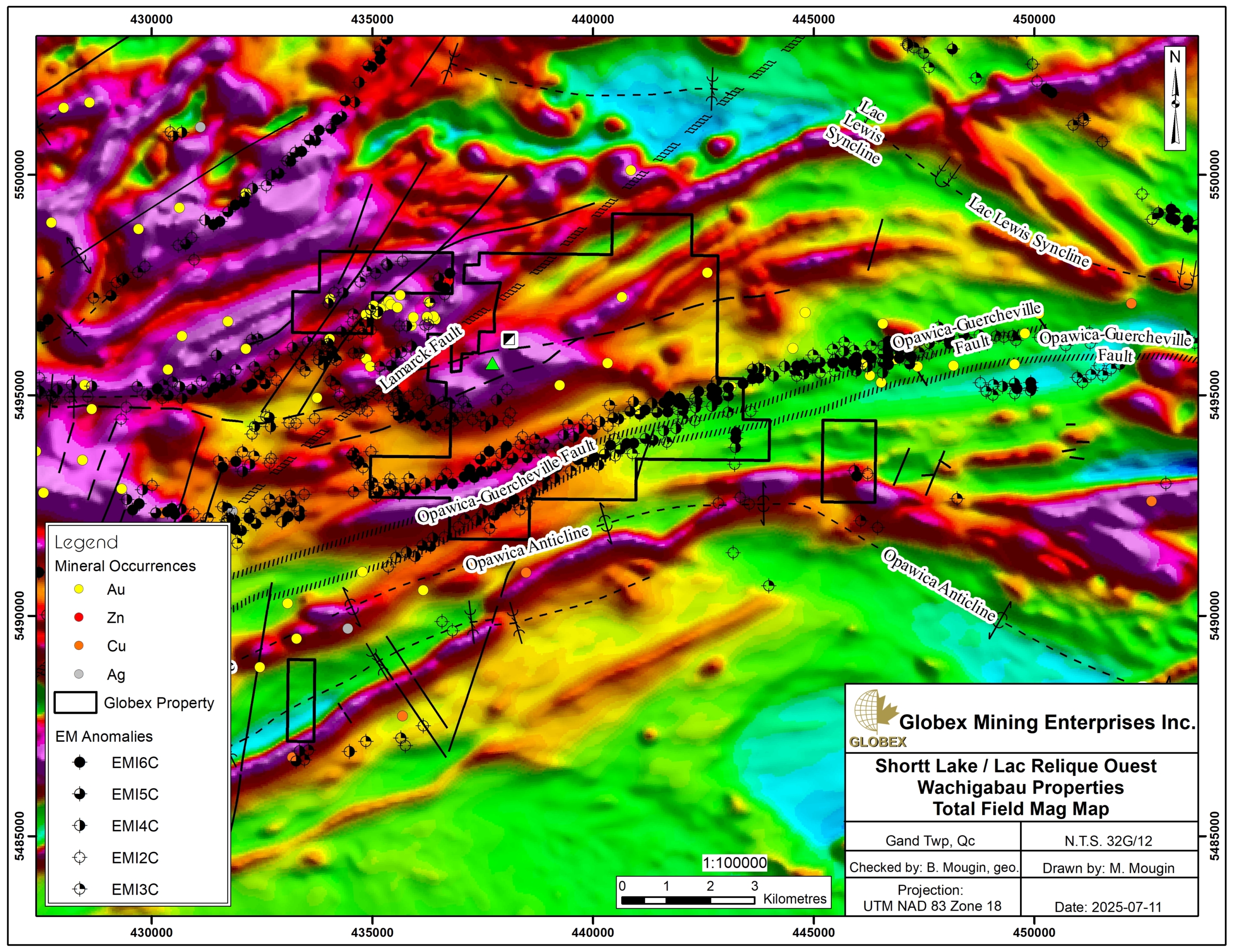
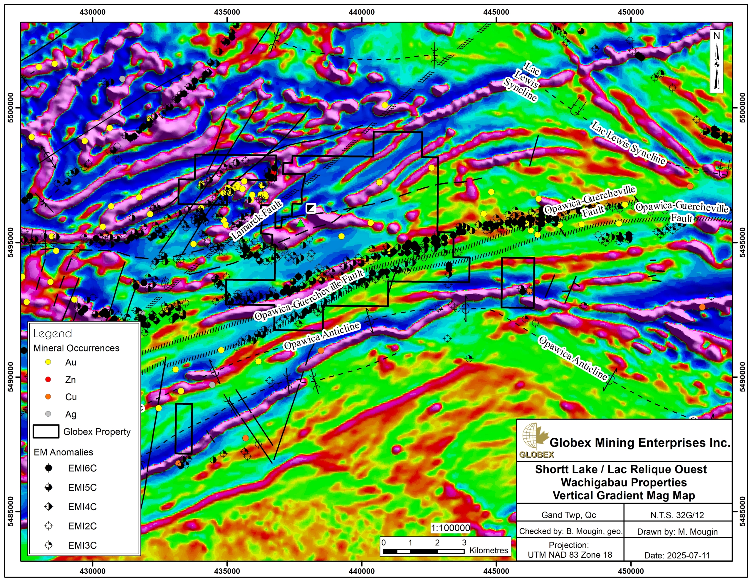
The Opawica-Guercheville shear corridor runs on 7 km on the Shortt Lake property. Strong Au anomalies are reported throughout the property and justify further exploration. Gold mineralization seems strongly spatially associated with positive magnetic anomalies and numerous EM anomalies. Further work should include new geophysical surveys (EM and IP) in order to highlight coincident anomalies. Depending on results, mechanical stripping and DDH should be necessary.
Historical resource of 525,332 t @ 4.87 g/t Au are still reported at the Shortt Lake Mine (Rioux, 2022 – GM72671).