Silidor / New Marlon Gold Mines
Location, Access, Description
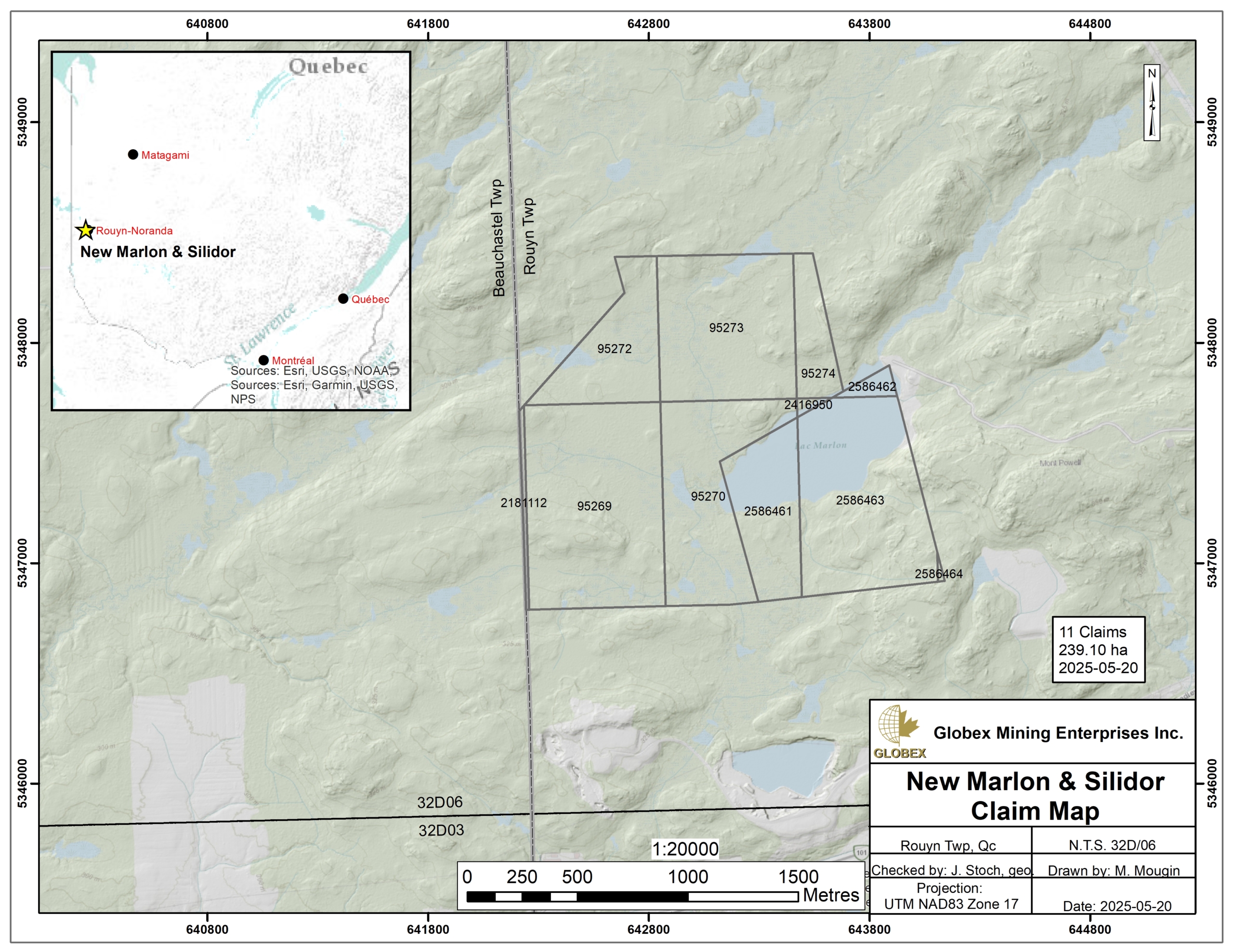
The Silidor / New Marlon property is located in the Abitibi-Temiscamingue region of Quebec Province. It is composed of 11 contiguous mining cells totalling 239.1 ha in Rouyn township (NTS 32D06), about 3 km west of the town of Rouyn-Noranda. The claims are fully held by Globex and are not subject to any third-party interests.
The property is easily accessible by road from Rouyn-Noranda driving about 3.5 km west on the Powell gravel road which leads to the New Marlon former mine about 0.5 km further west. The property is located on public lands where mining exploration is allowed without specific restrictions, except that of complying with current environmental laws.
Numerous commodities can be found in Rouyn-Noranda regarding contractors, skilled labor, equipment rental, as well as sleep and food accommodation of remote workers, even a smelter. Several Hydro power lines are located in the vicinity of the property.
Geology and Mineralization
Regional Settings
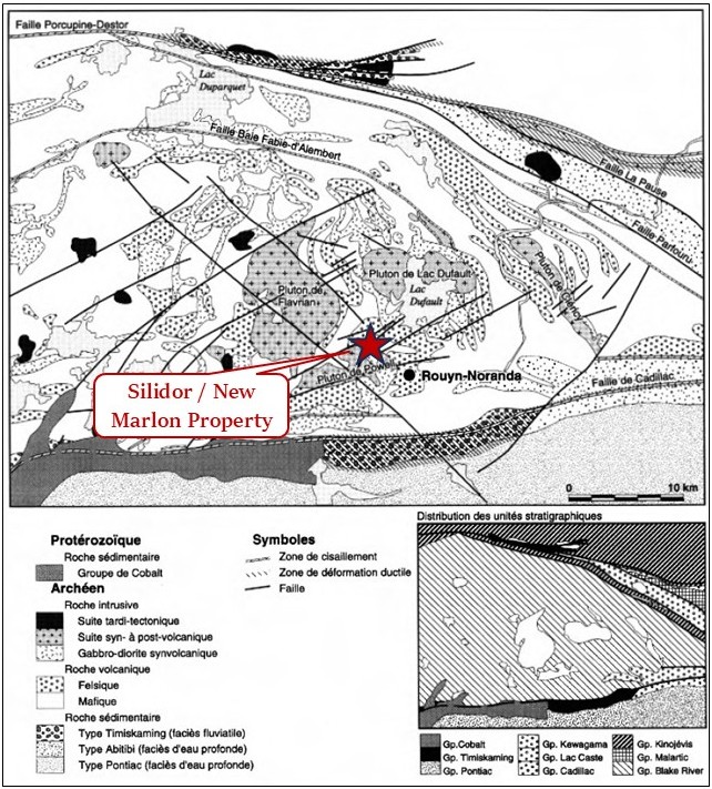
The Silidor / New Marlon property is located in the Abitibi Sub-province of the Canadian Shield. The Abitibi Sub-province is formed of Archean volcanic and sedimentary rock assemblages deposited between 2,730 and 2,690 Ma (Chown et al., 1992; Daigneault et al., 2002) injected by large masses of intermediate to felsic plutonic rocks. All these lithologies were deformed and verticalized during the Kenorean orogeny that occurred about 2.7 Ga ago (Percival et al., 2006; Percival, 2007). Regional metamorphism is at the greenschists grade and locally reaches the lower amphibolite grade around large Archean intrusions.
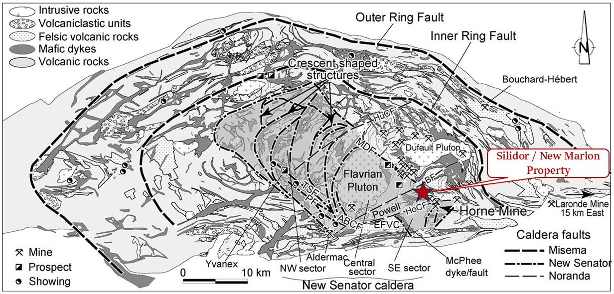
In the property area, the Archean Blake River Group of the Abitibi greenstone belt represents a bimodal calk-alkaline and tholeiitic subaqueous megacaldera complex (Pearson and Daigneault, 2009) which evolved over 8–11 Ma from approximately 2,701 to 2,696 Ma (Lafrance et al., 2005), and whose main characteristics are : 1) radial and concentric arrangement of mafic and intermediate synvolcanic dykes, 2) Dome geometry of the volcanic strata and 3) internal and external ring-shaped synvolcanic faults between which are distributed complexes of volcanoclastic rocks as well as a regional alteration in carbonates (MB2009-19). The superstructure is formed of at least three distinct and embedded caldeiras (Misema, New Senator and Noranda).
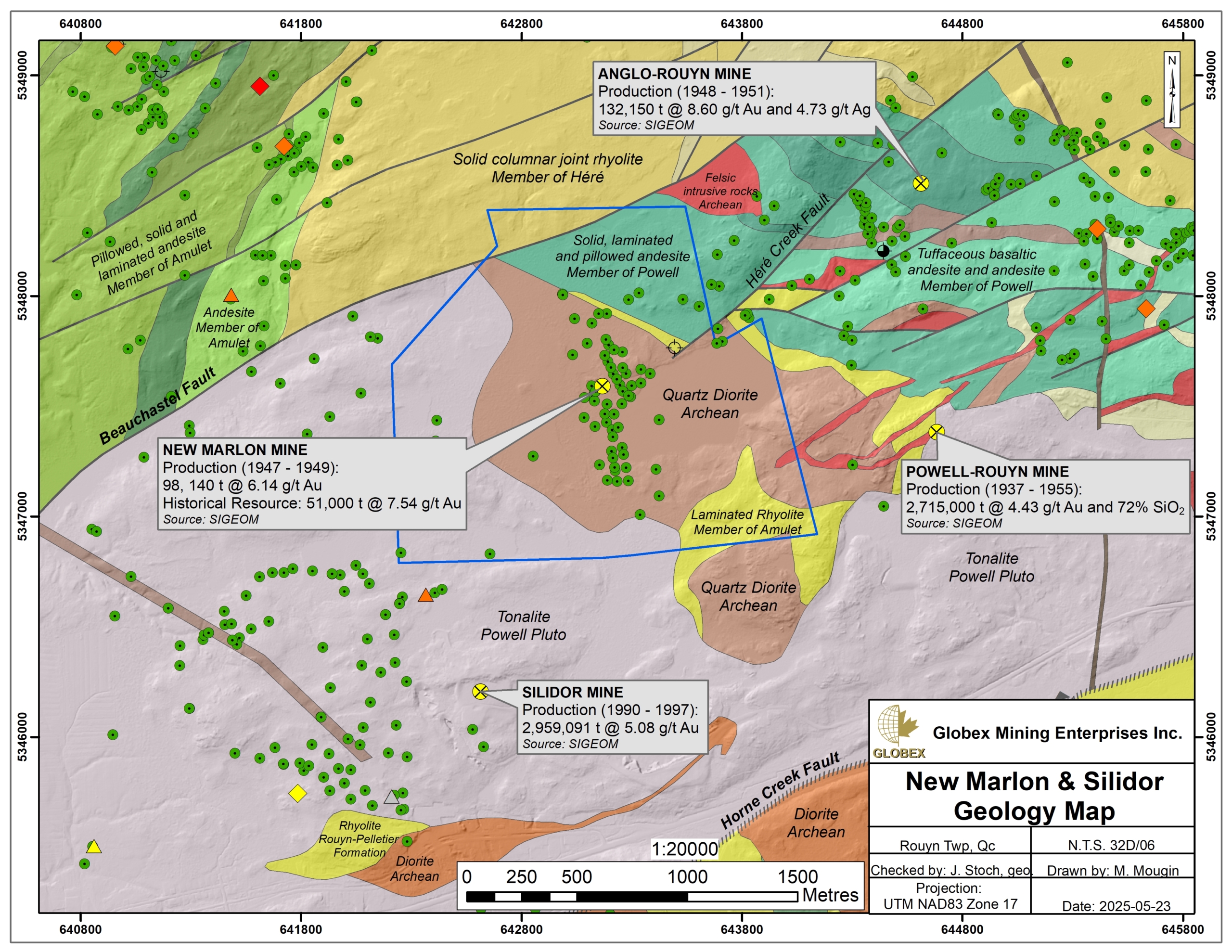
The Silidor / New Marlon property is bounded by the Beauchastel Fault to the north, and by the Horne Creek Fault (HCF) to the south. These two regional structures are oriented approximately N070°, which corresponds to the direction of the main mineralized hydrothermal system in the Rouyn-Noranda megacaldera (MB2009-19). Numerous ENE to E-W secondary faults are also listed in the area.
The Noranda Caldera corresponds to the final collapse of the volcanic system, culminating between 2,700–2,696 Ma (Mueller et al., 2012). This felsic-dominated event produced a N070° oriented graben structure that is delimited by the Horne Creek (to the south) and Hunter Creek (to the north) faults. In the Blake River Group (BRG), most of the volcanogenic massive sulphide (VMS) deposits are located in the Central Camp and are strongly linked to the evolution of the Noranda caldera and frequently associated with the N070° hydrothermal system (MB2009-19).
The volcanic and sedimentary rocks of the Rouyn-Noranda region were injected by several types of pre- to late-tectonic intrusive rocks; synvolcanic gabbro-diorite dykes and sills interpreted as comagmatic to mafic volcanic rocks; syn- to post-volcanic felsic plutons; syn- to post-tectonic felsic stocks and dykes, and Proterozoic diabase dykes (MB96-06).
Property Geology
The Silidor / New Marlon property is located in the Noranda Caldera. Following the geological mapping of Quebec Ministry’s geologists, the property is located on archean basement, centered on a archean quartz-diorite intruding the Powell Pluton. This synvolcanic pluton (Goldie, 1976; Mueller et al., 2012) is mainly composed of grey tonalite hosting enclaves of rhyolite, andesite and diorite. Isotopic datation by McNicoll et al. (2014) reveals an age of 2,700.1 (±1) Ma close to that of the synvolcanic Flavrian Pluton located immediately to the NW.
Laminated rhyolite of the Amulet Member are observed around the quartz-diorite intrusion on the property. The Amulet Member is related to numerous VMS mineralizations within the Noranda Central Camp, as the Waite-Amulet (C, A et Bluff) former mine. These mineralizations are associated with felsic centers or are closely linked to the presence of small rhyolitic domes.
Laminated and pillowed mafic volcanics of the Powell Member are present in the north of the property. The andesite is dark green, completely aphyric and contains laminated pillows (de Rosen-Spence, 1976). The rock is highly altered and shows intense chloritization in large areas.
Some NE- to ENE-oriented archean felsic intrusions are reported east of the Silidor / New Marlon property cross-cutting both the quartz-diorite and volcanics, which implies these rocks are late in the evolution of the megacaldera.
The N050°-oriented Héré Creek fault strikes in the east part of the property.
Regional Metallogeny
The Rouyn-Noranda area is rich in metallic deposits among which several are locatel in the Silidor / New Marlon property area. Since the discovery of the Horne deposit in 1927, mineral resources have been mined from more than 42 mines, including several world-class ones. The region of the BM property contains at least three types of mineralization : 1) volcanogenic massive sulfide (VMS) Cu ±Zn ±Au+Ag mineralization that occurs as disseminations, veinlets or exhalative horizons ; 2) magmatic-hydrothermal mineralization that is mainly related to intrusive and hydrothermal breccia zones ; and 3) orogenic gold mineralization that occurs as weakly pyrite-mineralized quartz + carbonate veins and veinlets.
Most of the VMS deposits of the Rouyn-Noranda mining district are located in the Central Camp and are strongly linked to the evolution of the Noranda caldera. Faure (MB2009-19) observed a strong relationship between VMS deposits and some orientations of faults and mafic dykes in the BRG. Most of N050°-N090° and N090°-N135° faults are interpreted as synvolcanic structures. The N050°-090° fault system at Central Camp is unique to the BRG and is aligned elsewhere in Abitibi with other synvolcanic faults (MB2009-19).
The former Silidor mine is located about 500 meters south of the property. This deposit was discovered by drilling in 1985 and was mined from 1990 to 1997. The Silidor mine mineralized zone was formed in a weak zone of the Powell Pluton containing a mafic dyke. It is a vein-type deposit associated with quartz-carbonate veins in a shear zone intersecting intrusive rocks (tonalite-trondhjemite) of the Powell Pluton (Gaulin, 1992). A total of 2,959,091 tonnes of ore grading 5.08 g/t Au were extracted from this mine.
The Cadillac – Larder Lake fault strikes about 7 km south of the BM property in a roughly E-W direction. This regional structure represents one of the most important gold metallotects in the Abitibi Sub-province and hosts numerous deposits > 100t Au (Kirkland Lake, Kerr-Addison, Sigma-Lamaque, Malartic…).
Property Mineralization
The Silidor / New Marlon property hosts the New Marlon former gold mine whose historical production (1947-1949) is estimated to 98,140 t @ 6.14 g/t Au. This gold, silver and copper deposit is vein-type, hosted in a shear zone (Héré Creek fault). A main vein extends over a length of more than 400 m, with a width varying from 0.3 to 2 m, to a depth of 270 m in a N345°/70° direction.
The mineralized quartz-carbonate veins are located in fractures belonging to a dioritic facies of the Powell granite and in a carbonate mafic dyke that have been filled by mineralized solutions. Disseminated mineralization consists of gold-bearing pyrite (coarse) accompanied by gold, chalcopyrite and silver. Alteration in the footwall consists of carbonation, silicification and pyritization.
Best assays in historical DDH after the mine closure include 0,34 g/t Au, 0,04 % Cu and 0,37 % Zn over 0,20 m in DDH R 88-02, located more than 400 meters southwest of the New Marlon mine (GM48335). Sphalerite and chalcopyrite mineralization is observed in a chloritized and brecciated diorite between 213 and 214 meters deep.
History
Very few historical work are listed on the Sigeom public database of historical work on the property. Exploration of the property has essentially been undertaken in two phases :
1937 – 1949 :
From 1937 to 1947, Marlon Rouyn Gold Mines Ltd. carried out field mapping, sampling, geophysiocs, and DDH (53 holes). The New Marlon mine then entered in production from 1947 to 1949 for a total production of 98,140 t @ 6.14 g/t Au. The main vein follows a weak shear that strikes N015° west and has an average dip of 70° east (GM00827). The ore was taken to the Francoeur mill by trucks. Development work on the 750 foot level indicated only 30 feet of ore, so operations were suspended in May, 1949. Exploration in this sector was then put on hold for 30 years.
1979 – 1989 :
Noranda Exploration Ltd. and Cambior Inc. undertook further exploration and DDH in the vicinity of the New Marlon mine during the 1980’s, drilling sixteen (16) DDH in ten (10) years. Best assays of this work include 0,34 g/t Au, 0,04 % Cu and 0,37 % Zn over 0,20 m (GM48335).
According to Sigéom, no drilling has been carried out below level 6 (230 m), although the vein appears to continue at depth.
2005 – present :
Globex acquired the property in 2005 but no work has been undertaken since 2015. In 2015, Globex carried out a grab sampling program in the Lac Marlon area (GM69481). The objective of the work was to visit the majority of the listed outcrops in order to verify the presence of mineralized quartz veins similar to and/or associated with the main vein of the New Marlon deposit. A total of 11 samples were collected, with the best gold value being 675 ppb Au.
In 2018, Globex wrote a compilation of historical geoscientific data on the Silidor / New Marlon property and formulated a series of recommendations for further exploration (GM70682).
Resources and Potential
The geological context of the Silidor / New Marlon property is strongly favorable to the discovery of both gold and base metals mineralization due to its location within the Noranda Central Camp and the presence of both the favorable Powell Pluton and the late Héré secondary fault which remobilized and concentrated primary mineralizations.
Historical DDH on the property after the mine closure returned assays up to 0,34 g/t Au, 0,04 % Cu and 0,37 % Zn over 0,20 m in brecciated and chloritized diorite more than 400 meters southwest of the New Marlon mine (GM48335). No follow-up drilling or trenching appears to have been carried out since, despite several surface outcrops identified in Sigéom in this area.
A second zone of interest lies below the deepest level of the New Marlon mine, at a depth of 750 feet (±230 m). The mine ceased operations in 1949 due to “low-grade ore”, which was ore grade of 6.86 g/t Au (in 1949, gold was worth $35US/oz). No drill holes ever investigated the mineralization below the last mined level. A resource (not compliant with NI 43-101) of 51,000 tonnes grading 7.54 g/t Au is estimated at the New Marlon mine in the mineral deposit sheet 32D06-0099 (Sigeom).
Previous work has also identified numerous gold and base metal showings in the area of the property, as well as favorable geological and structural features for the emplacement of both gold and base metal mineral deposits. One of the most researched metallotects for VMS exploration in the Noranda Central Camp is the presence of synvolcanic faults. Research work on VMS fertile synvolcanic faults in the Blake River Group (BRG) by the CONSOREM in 2009 (MB2009-19) highlighted that most fertile faults are associated to the N070° synvolcanic hydrothermal system. Several criteria for recognizing synvolcanic faults are presented by Gibson et al. (1997), including:
– Intensification, unconformity and abrupt changes in hydrothermal alteration;
– Abrupt changes in thickness along volcanic units or net termination of units
– Presence of coarse, localized volcanic breccias discordant with the units (Franklin, 1993); fragmentary, foliated or schistose rocks; and quartz veins, stockwerks and sulfide veinlets;
– Rhyolitic domes (Dimroth et al. 1978);
– Unfaulted units overlying faulted sequences;
– Networks of dykes or apophyses linked to synvolcanic intrusions;
– Changes or ruptures in the direction and/or dip of volcanic units.
In the GBR, the vast majority of faults dip steeply, generally more than 70°, particularly in the Central Camp (Gibson 1983; Gibson and Watkinson 1993).
Future work on the Silidor / New Marlon property should therefore include :
- Prospection and grab sampling in the area of hole R 88-02 in order to verify the presence of a anomalous halo at this place. Depending on the assay results, rock stripping should be considered ;
- A few short DDH in order to test the extensions of the Au mineralization under 230 meters deep below the former New Marlon mine ;
- A compilation of historical geophysical data in order to verify for the presence of unknown structures on the property. The VLF-EM method is particularly suitable for this purpose. Particular attention should be paid to the N070° orientation, following recommendations of Faure (MB2009-19). Depending on the amount of historical data available and usable, further geophysical surveys (Mag, VLF-EM, IP) should be considered.

