
Wasamac East
Location, Access, Description
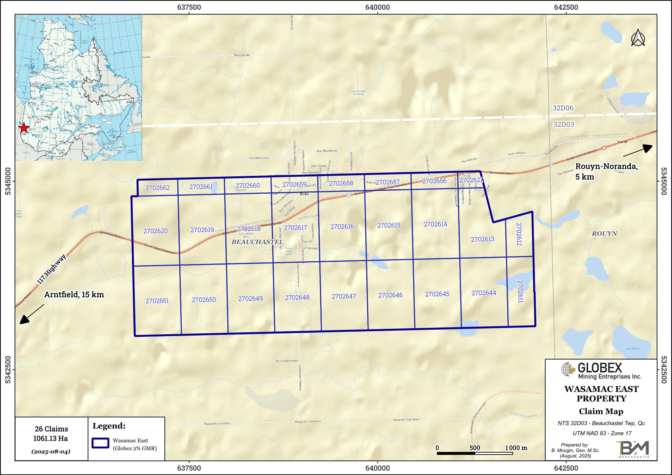
The Wasamac East property is located in the Abitibi-Temiscamingue region of Quebec Province. It is composed of 26 contiguous mining cells totalling 1061.13 ha in Beauchastel township (NTS 32D03), about 5 km west of the town of Rouyn-Noranda and 3 km NE of the advanced Wasamac Project of Agnico Eagle Mines. The claims are held by Agnico-Eagle Mines, and Globex retains a 2% Gross Metal Royalty (GMR).
The property is easily accessible by road from Rouyn-Noranda driving on Highway 117 north. A dense network of gravel and logged trails runs throughout the property. Numerous commodities can be found in Rouyn-Noranda regarding contractors, skilled labor, equipment rental, as well as sleep and food accommodation of remote workers. Several high-voltage power lines are located in the vicinity of the property.
Geology and Mineralization
The Wasamac East property is located in the Abitibi Subprovince of the Canadian Shield which is formed of Archean volcanic and sedimentary rock assemblages deposited between 2,730 and 2,690 Ma (Chown et al., 1992; Daigneault et al., 2002) injected by large masses of intermediate to felsic plutonic rocks. All these lithologies were deformed and verticalized during the Kenorean orogeny that occurred about 2.7 Ga ago (Percival et al., 2006; Percival, 2007). Regional metamorphism is at the greenschists grade and locally reaches the lower amphibolite grade around large Archean intrusions.
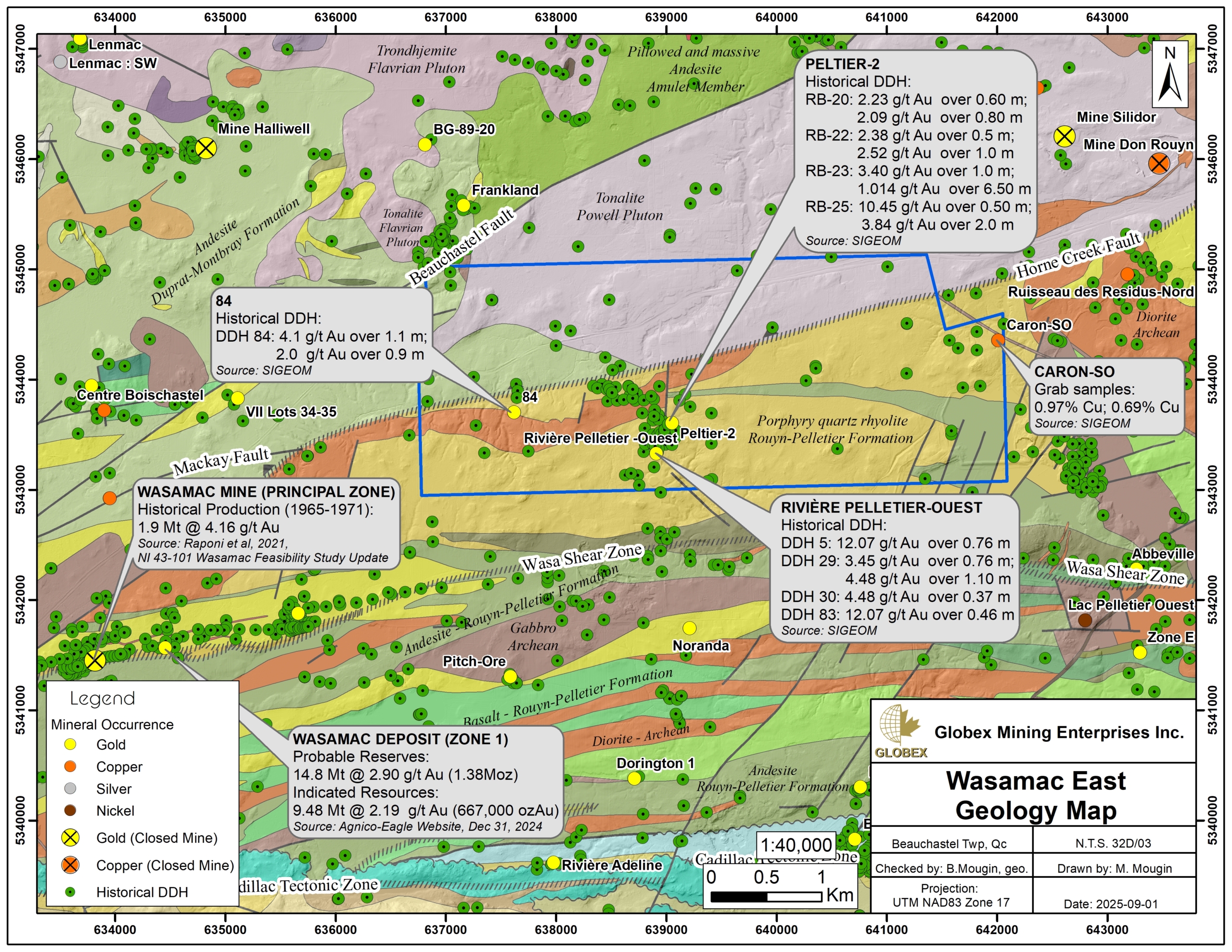
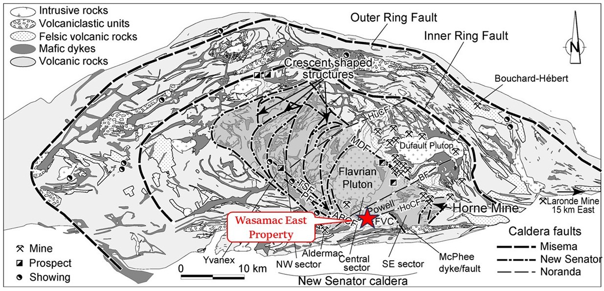
Rocks of the Wasamac East property are composed of tonalite of the Powell Pluton north of the Horne Creek Fault (HoCF) and quartz-porphyritic rhyolite of the Blake River Group (BRG) south of the HoCF. The BRG is defined as a bimodal calk-alkaline and tholeiitic subaqueous megacaldeira (Pearson and Daigneault, 2009) which hosts several world-class gold and base metal deposits of the Noranda Mining Camp. Most of the volcanogenic massive sulphide (VMS) deposits are located in the Noranda Central Camp and are strongly linked to the evolution of the Noranda caldera which corresponds to the final collapse of the volcanic system (MB2009-19).This event produced a N070° oriented graben structure that is delimited by the Horne Creek Fault (HoCF) and Hunter Creek Fault (HuCF). The Powell Pluton is synvolcanic and is associated with the New Senator caldera event (Goldie, 1976; Mueller et al., 2012).
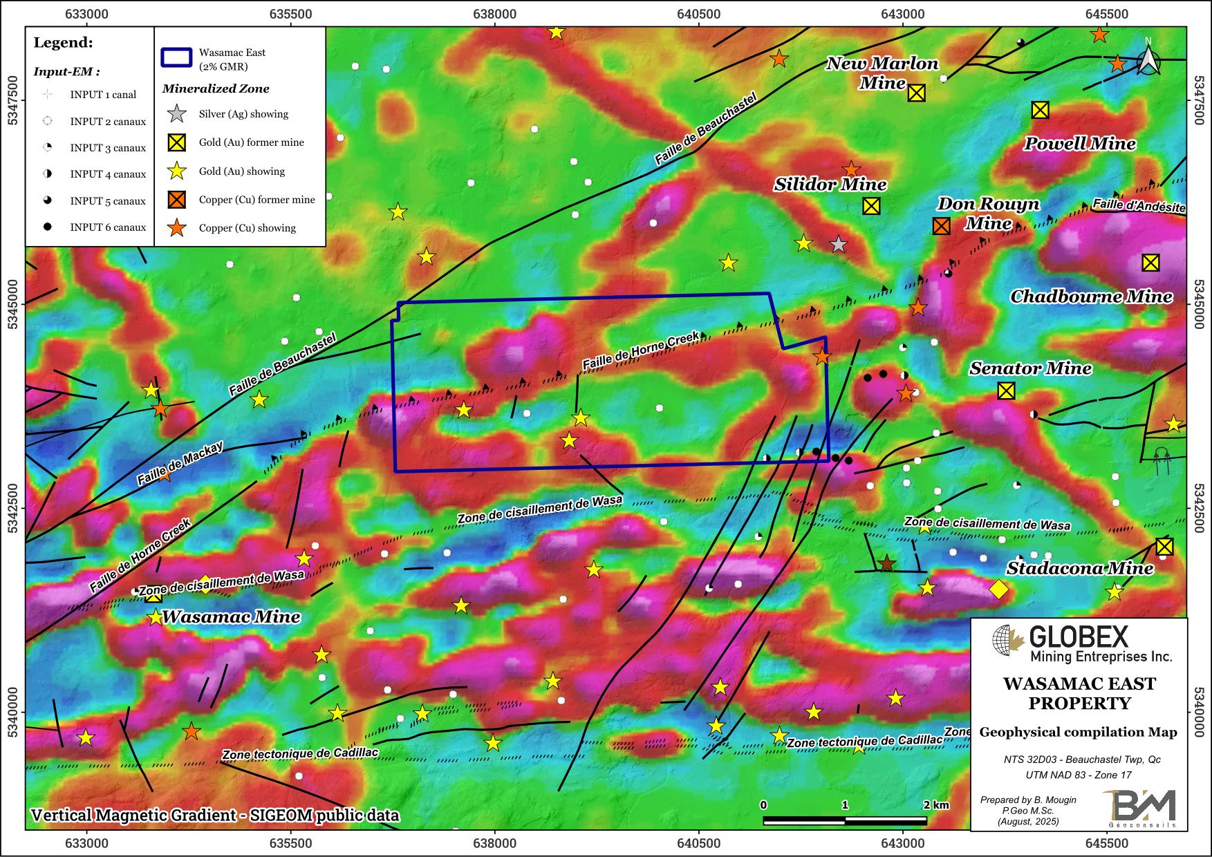
Several regional mineralized structures are listed in the property area ; those include the Beauchastel Fault, the Horne Creek Fault (HoCF), the Wasa Shear Zone (WSZ) and the Cadillac Larder-Lake (CLL) Fault. Each of these structures is associated with gold and base metal showings and deposits. The HoCF which represents the southern limit of the Noranda Caldeira runs through the property in a NE-SW orientation.
Proterozoic diabase dykes cut through every Archean lithologies in NE orientation (Abitibi Dykes), NW orientation (Sudbury Dykes) and N-S orientation (Matachewan Dykes).
The Rouyn-Noranda area is rich in metallic deposits. Since the discovery of the Horne deposit in 1927, mineral resources have been mined from more than 42 mines, including several world-class ones (Quebec Government’s Report MB96-06). The region of the Wasamac East property hosts at least three types of mineralization : 1) volcanogenic massive sulfide (VMS) Cu ±Zn ±Au+Ag mineralization that occurs as disseminations, veinlets or exhalative horizons ; 2) magmatic-hydrothermal mineralization that is mainly related to intrusive and hydrothermal breccia zones ; and 3) orogenic gold mineralization that occurs as weakly pyrite-mineralized quartz + carbonate veins and veinlets.
The Francoeur-Wasa shear zone strikes about 500 metres south of the property. It represents the first order mineralized feature of the area and it is associated with first-class gold deposits including the former Francoeur mine (Measured & Indicated Resources of 320,066t @ 6.86 g/t Au on the West Zone in date of December 31st, 2013 – Adam, 2014, NI 43-101 Technical Report for the Francoeur Gold Project) and the Wasamac deposit (Probable Reserves of 14.8 Mt @ 2.90 g/t Au – Agnico-Eagle website, December 31st, 2024). Gold mineralization at Wasamac is typically associated with finely disseminated pyrite and stockwork of pyrite-rich microveinlets hosted in albite-sericite-ankerite alteration zones confined within the shear zone (Raponi et al., 2021 – NI 43-101 Technical Report on the Wasamac Feasibility Study Update).
The Cadillac – Larder Lake fault strikes about 3.5 km south of the Wasamac East property in a roughly E-W direction. This regional structure represents one of the most important gold metallotects in the Abitibi Sub-province and hosts numerous deposits > 100t Au (Kirkland Lake, Kerr-Addison, Sigma-Lamaque, Malartic…).
The Wasamac East property hosts four (4) metallic showings. The Caron-SO showing (assays up to 0.97% Cu on grab samples) consists of quartz veins containing pyrite and chalcopyrite intruding a gabbro. The Peltier-2, 84, and Rivière Pelletier-Ouest gold showings consist of orogenic quartz-carbonate veins with weak sulphide mineralization, hosted in silicified quartz-feldspar porphyry (QFP). Assays up to 12.07 g/t Au over 0.76 m are reported in DDH on the Rivière Pelletier-Ouest showing (GM06270-B).
History
Numerous historical work have been undertaken in the area of the Wasamac East property since gold mineralization was first discovered at Fortuna Lake in 1906 by prospectors Alphonse Ollier and Auguste Renaud. These included geological mapping and grab sampling, trenching, channel-sampling, numerous ground and airborne geophysical surveys (Mag, EM, IP) as well as thousands of meters of diamond drilling (DDH). A total of 119 historical DDH are listed on the Wasamac East property in Sigéom public database.
Gold mineralization was originally discovered on the Wasamac Block in 1936 by Mine d’Or Champlain through surface trenching. Subsequent surface diamond-drilling led to the sinking of a 60-metre shaft (Wildcat shaft), and one underground level was developed. Mine production at the Wasamac mine was only between 1965 and 1971, approximately 254,000 oz Au (approximately 1.9 Mt @ 4.16 g/t Au) were extracted (Raponi et al., 2021).
The Francoeur mine was operated in three periods between 1938 and 2012, for a total Production of 508,642 oz Au (2.60 Mt @ 6.1 g/t Au). The Arntfield mine, which comprises the No.1, No.2, and No.3 deposits, produced 480,804 t @ 3.98 g/t Au and 0.93 g/t Ag from 1935-1942 (Raponi et al., 2021).
Resources and Potential
Definition of the Wasamac deposit is still ongoing southwest of the Wasamac East property. The Wasa Shear Zone appears to be displaced by the NE-trending Horne Creek Fault (HoCF) which runs on the property. Remobilization of primary sulphide mineralization could have occurred along the HoCF during this event.
Further exploration of the Wasamac East property should target both gold mineralization associated with faults and shear zones, and VMS mineralization within volcanics of the Rouyn-Pelletier Formation.