
Rousseau
Location, Access, Description
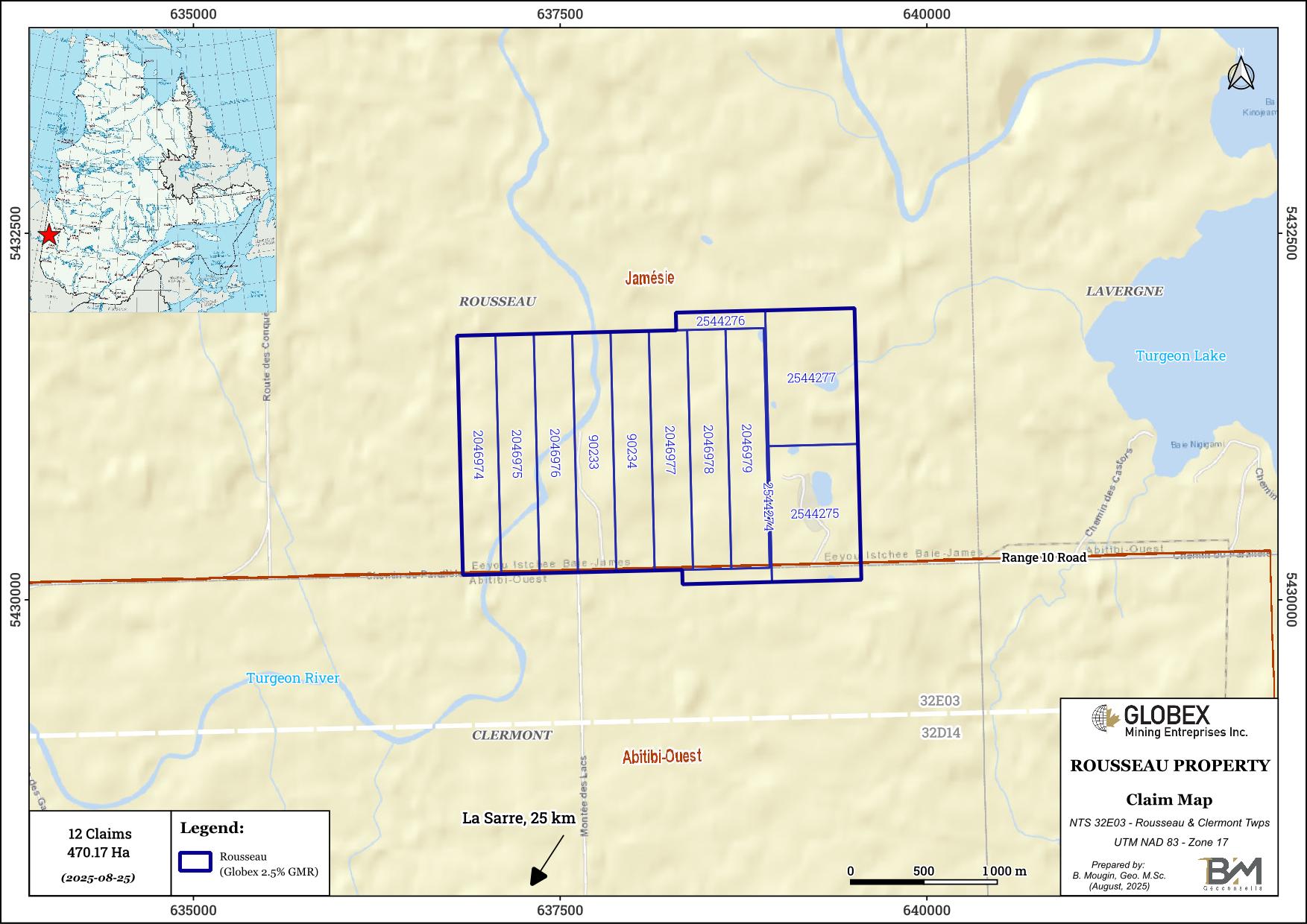
The Rousseau property is located on the border between Abitibi-Ouest and Jamesie, about 25 km north of La Sarre and 85 km north of Rouyn-Noranda. The property consists of 12 mining claims totaling 470.17 Ha in NTS 32E03. The claims are held by Starr Peak Mining, and Globex retains a 2.5% Gross Metal Royalty (GMR).
The property is easily accessible in vehicle from Rouyn-Noranda via provincial highway 101 north to Destor, then taking west on provincial highway 393 past Val-St-Gilles and finally Ranges 10 to the east. Numerous commodities can be found in Rouyn-Noranda regarding contractors, skilled labor, equipment rental, as well as sleep and food accommodation of remote workers.
Geology and Mineralization
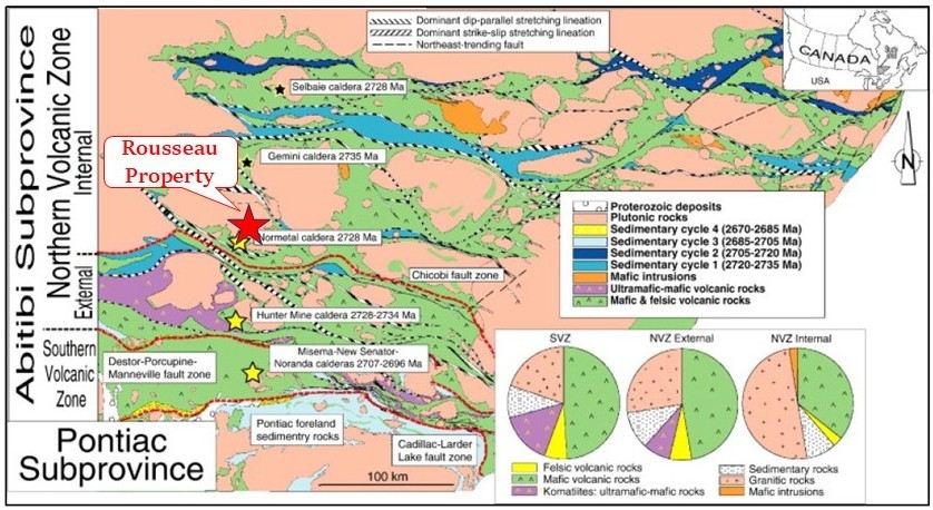
The property is located in the North Volcanic Zone (NVZ) of the Abitibi Subprovince. The Abitibi Subprovince is an Archean greenstone belt which hosts some of the richest mineral deposits of the Superior Province.
Rocks of the area are essentially composed of mafic and felsic volcanics of the Clermont-Disson Formation and the Normétal Volcanic Complex. The Val-St-Gilles pluton (tonalite/trondhjemite/granodiorite) is the largest intermediate intrusive mass of the area. According to geochronological data, it is part of the large synvolcanic plutons of the NVZ that were emplaced around 2,722 Ma to 2,714 Ma (Chown et al., 1992). All Archean units were verticalized during the Kenorean Orogenesis, and structured in bands cut by regional E-W shear zones. Late intrusions and NW-SE dextral faults and NE-SW senestrial faults terminate the structural organization of the region (Guemache, 2020 – RG2018-01).
A thick sequence of clay covers the area so that very few outcrops are available on the Rousseau property ; geology is essentially deduced from historical drilling data (DDH). The Rousseau property is occupied by the Val-St-Gilles Pluton which consists here of biotite-trondhjemite and biotite-tonalite (Beausoleil, 2000a-b, 2005; Beausoleil and Doucet, 1998, 2002a-c; Chabot et al., 2003; Deschênes, 2012; Deschênes et al., 2015), as well as tonalite with rhyolite enclaves and granophyric tonalite (Guemache, 2020).
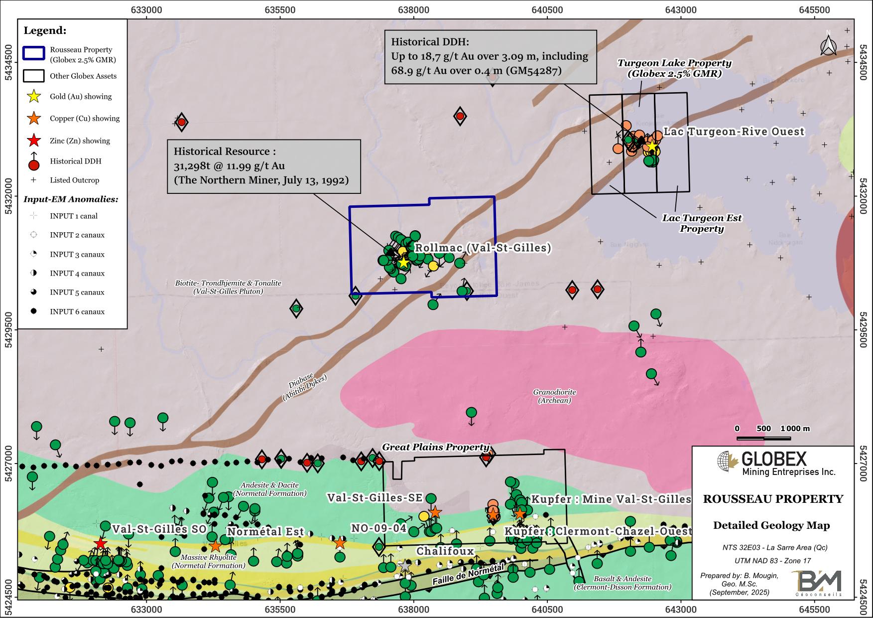
Two (2) Proterozoic diabase dykes cross the property in a NE-orientation (Abitibi Swarm).
The Rousseau property is located in the Neoarchean Burntbush-Normétal volcanic belt which includes a wide range of compositions from basalt through andesite to rhyolite and their subvolcanic equivalents. These rocks are favourable for volcanic massive sulfides (VMS – eg: Normétal mine and Normétmar satellite) and for gold development (eg: Amex Exploration – Perron project).
Three (3) types of mineralization are observed in this area : 1) Exhalative stratiform with massive and disseminated sulfides (pyrite, pyrrhotite, chalcopyrite, sphalerite, silver and gold), 2) Disseminated pyrite, pyrrhotite, chalcopyrite and bornite in Normetal volcanics, and 3) Cu-Mo porphyry with chalcopyrite, pyrite and molybdenum in veins and fractures affecting the Val-St-Gilles pluton. Alterations associated with mineralization include chlorite, silica and sericite.
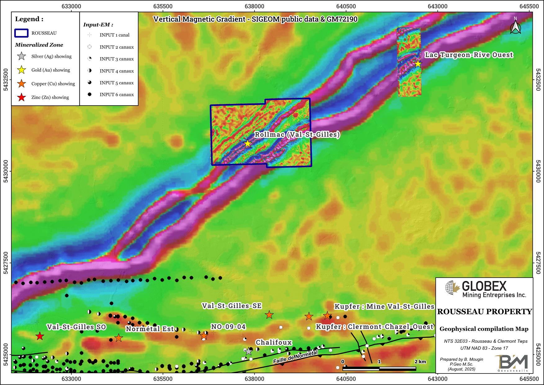
The felsic intrusive rocks of the Val-Saint-Gilles pluton is host for two (2) occurrences of veintype gold mineralization, namely Rollmac (Val St-Gilles) and Lac Turgeon-Rive Ouest, which are emplaced along diabase dikes. The Rousseau property hosts the Rollmac (Val-St-Gilles) gold showing which is described by historical work as a multiples gold bearing quartz veins system hosted in the Val-St-Gilles granodiorite. Free gold occurs in cherty grey to milky quartz veins and in silicified granite adjoining the quartz veins. (GM53158). The sulfide (pyrite and chalcopyrite essentially) content varies from 1 to 5%. There is no relationship between gold grades and sulfide percentages. Four veins are exposed to the north of a northeast-striking common diabase. Historical DDH assays up to 29.83 g/t Au over 0.99 m and 3.77 g/t Au over 6.1 m have been intersected.
The Normétal fault, associated with several gold and base metals showings and deposits including the Normétal former mine (historical production 1937-1975 : 10,084,300 t @ 5.41% Zn, 2.24% Cu, 0.526 g/t Au and 44.45 g/t Ag) is located about 5 km south of the Rousseau property.
History
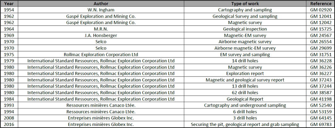
The first recorded exploration work on this property is the prospection of the Rollmac showing in the ends of the 1920s, which led to the construction of 2 exploration pits in 1929 by Teck Hugues Gold Mines Ltd. to follow the Veine Principale ant the Veine Mercier. Nothing much seems to have happened until 1954, when W.N Ingham’s work to cartography and sample the flooded pits. Table 1 below shows all exploration work referenced in the Ministère de l’Énergie et des Ressources Naturelles (MERN) database until 2021.
Historical work exposed four (4) mineralized veins, as follows :
Main Vein
The Main vein is located near center of lot 52, range I, Rousseau Township. It consists of irregular milky quartz vein (5-40cm) with an average of 30cm contained in a fractured zone. Quartz veining appears to have been introduced along the mud filled fractures and in places, recurring movement along fractures brecciated and rounded off some of quartz fragments. In the vicinity of the main shaft, the fracture zone (5-15cm) contains an average of over 30% quartz occurring in echelon along the fracture zone. The main vein strikes N58°W and dips 85°N. In the shaft area, the vein turns abruptly to the south and strikes N15W and joins up with another vein parallel to the main vein (GM36227). On the surface, the vein outcrops for a length of 9.2m and one of the main quartz vein in the fractured zone is reported to have returned 3 oz/t Au / 30.5cm . In the shaft, it returned 1.34 oz/t Au / 76.2 cm. At the bottom of the shaft, it is reported to have assayed 3 Oz/t Au/ 76cm. At that time a 9.54 ton bulk sample made out in part from material mined out from this part of the main vein exposed on surface and from material taken from the dump was shipped to the Noranda smelter and returned 0.65 oz/t of gold. Lately a 28 ton bulk sample mined out from this part of Main vein exposed on surface and at lower levels than in 1975 was also shipped to the Noranda smelter and returned 0.77 oz/t of gold and 6.51 oz/t of silver. During the last half of 1979, the main vein was tested at shallow depth (12 holes) with a small Winkie drill. This work tested the zone to a depth of 22 m below surface and a long strike from 22.8m west to 9.2m east of shaft. Of 4 holes drilled under this part of which was bulk sampled, hole No.14 returned 0.43 opt along a core length of 2.34 m, hole No. 13, 0.12 oz/t Au / 1.89m or 0.31 oz/t Au / 0.52m, hole No.4, 0.19 oz/t Au 0.64m and hole No.5 drilled under hole 4 was drilled short and did not intersect the zone.
Mercier Vein
The Mercier vein (15.2-61cm) is found 183m northeast of the Main vein and consists of white quartz in silicified, carbonatized and well pyritized granite at least 1.83m, but quartz itself carries only minor sulfide. The vein lies in granite, strikes N70°W dips 80°S. This vein has been explored by one large trench, a 1.83m x 6.1m shaft sunk to depth of 4.87m near the east end of the vein. It is reported that a composite sample along a length of 6.2m in the shaft returned 0.11 ounce gold per ton (W.N.Ingham, Quebec department of mines, 1954). Also, it is reported that quartz samples from the dump returned 0.2 and 0.3 ounce of gold per ton (J.F.B. Davis, 1958). He also reports that a sample taken from a parallel vein, 15.3m to the north, assayed 0.428 ounce of gold per ton. In late 1979, the Mercier vein was tested by 2 holes drilled to intersect the vein below the shaft at 9.2m and 15.3m below surface. Both of holes intersected a silicified diabase dike where the vein was expected.
Third vein
The third vein is found in the No. 3 pit, 61m west of the Mercier shaft, it’s reported that quartz taken from the dump returned 0.43 oz/t of gold.
Fourth vein
The fourth vein is located 122m north-east of Mercier vein, not much information is available of this occurrence.
In 2021 and 2022, Starr Peak Mining carried out high-definition drone magnetic survey (GM72190) and 3,200 m (9 holes) of diamond drilling (GM73426) to evaluate the Veine Principale (Rollmac) and the Veine Mercier extension and test their continuity in depth. Best assays included 2.18 g/t Au over 1.50 m (RO-22-07) and 47.3 g/t Au over 0.30 m (RO-22-03) in direct SE extension of the Main Vein.
Resources and Potential
The Rousseau property remains interesting in regard to the historical high gold grades potential and the 2022 anomalous results. By analogy to the geologically-similar environment in the Bourlamaque Batholith and to the numerous gold zones known to be related to periods of structural deformation of acid intrusive. The results obtained to-date by bulk sampling (see history of exploration section) show that the property has a good exploration potential and warrants further work.
It is therefore recommended that the exploration work program be done to further evaluate the potential of the property. This program ought to consist of a geological compilation and geophysical surveying, further prospecting and diamond drilling to test the best geophysical targets outlined. Starr Peak recommends focussing next phase of work at testing Veine Mercier extensions and underneath drill hole RO-22-03.
Historical Resource of 31,298t @ 11.99 g/t Au have been estimated in 1992 (The Northern Miner, July 13, 1992, p.14).